1. 서 론
드론 기술과 산업이 발전하고 가격 하락 등으로 인하여 방위산업뿐만 아닌 건설, 에너지, 영상, 예술 분야 등 다양하게 활용되고 있다. 재난 분야에서도 드론의 활용성이 높아짐에 따라, 재난 붕괴지형의 매몰자 위치 탐지, 교량 및 초고층건물의 안전성 진단, 수질오염 감시, 대기오염 원격 감시, 긴급 구호품의 운송 등 재난관리 단계의 전주기 과정에 활용되고 있으며, 특히 산림분야에서는 산림보호를 위한 산불감시, 병충해 예찰, 산림훼손 감시, 산사태 우려지역 감시, 산지지형정보 측량 등에 드론이 활용되어, 사람이 접근하여 확인하기 힘든 지역에 대한 정보를 획득하기 유리해졌다. 이러한 산지 지역에 대한 정보를 획득하기 위하여 기초적으로 공간정보를 구축해야하며, 공간정보를 구축하기 위해 지형정보의 생성이 필수적이다.
드론을 활용한 지형정보의 구축은 많은 연구자들에 의해 수행되었으며, Kwon (2016)은 제주도의 미지형의 근접 촬영을 통한 단위 지형의 특징을 파악, S.J. Lee and Y.S. Choi (2015)는 소규모 노천 광산의 지형측량, Choi et al. (2016)은 강릉지역의 사빈지역의 시계열 측정에 따른 지형 변화 탐지, Dewez et al. (2016)은 절벽 지형의 정보의 구축에 따른 위험지 분석, De Reu et al. (2016)은 중세시대의 항구 형태의 이해를 위한 고해상도의 지형정보 구축, Oh et al. (2017)은 갯벌의 드론 촬영을 통한 시계열 공간 지형정보 생성 등 다양한 지형의 정보를 구축한 사례가 있다. 드론을 이용하여 구축된 고해상도의 지형정보는 정확성 평가를 위해 위성영상과의 비교, 수치지형 생을 통한 확인, 고정익과 회전익의 정확성 비교 등 다양한 방법으로 검증되고 있다(Azmi et al., 2014; Uysal et al., 2015; Lee and Choi, 2016).
산지지역의 경우, 산사태의 발생지점과 토석류의 이동궤적, 퇴적 장소까지 위험성과 취약성을 사면단위로 분석하기 위해서는 높은 공간해상도를 가진 자료가 필요하다(Kasai et al., 2009). 이에 따라 드론 사진 측량을 이용한 산림 훼손지역 현황 분석(G.S. Lee and Y.W. Choi, 2015; Lee et al., 2016), 산지재해 발생 위험지역 분석을 위한 드론의 활용 가능성 연구(Lee et al., 2018), 산림공간정보 조사 및 분석(Shin et al., 2017; Oh and Jun, 2018; Park and Jung, 2018) 등 공간정보의 구축과 위험성 분석 연구가 수행되고 있으나, 사면위주의 지형에 국한 되어있다. 산지의 계류지역을 반영한 토석류 재해의 분석을 위한 공간정보의 구축과 분석에 관한 연구가 부족하여, 이에 대한 자료 구축방법과 분석 사례에 관한 연구가 요구되고 있다.
따라서, 본 연구에서는 계류부의 침식 특성이 반영된 토석류 발생지역에 대하여 드론을 이용한 지형 측량방법과 지형분석 방법 대해 제시하고, 1:5000의 수치지형도와 비교하여 측량정보의 정확도를 분석하였다.
2. 연구방법
2.1 연구지역 선정 및 조사방법
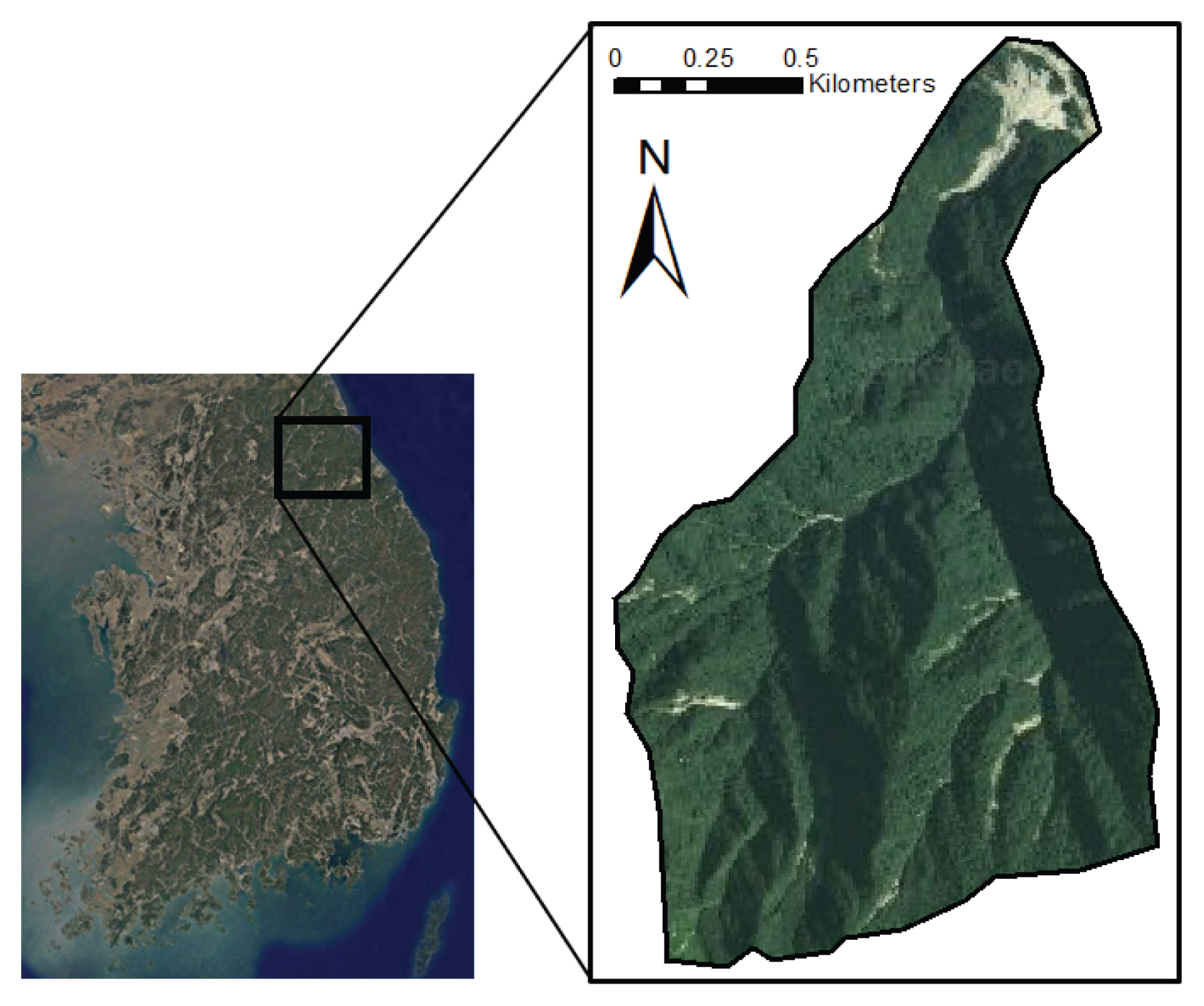
2006년 7월 태풍 에위니아와 집중호우로 인하여 강원도 전 지역에 걸쳐 토사재해가 발생하였고, 특히 인제군 북면 한계리 지역은 다수의 토석류가 발생하였다. 토석류 발생지 중에서 연구지역은 설악산 국립공원내 가리봉 북쪽사면의 유역을 대상으로 선정하였다(Fig. 1). 연구지역은 인명 및 재산의 피해가 없음에 따라 복구할 필요가 없는 지역으로 토석류의 현장 상황이 그대로 유지되어 있기 때문에 시간의 흐름에 따른 지형 변화의 분석이 용이하다.
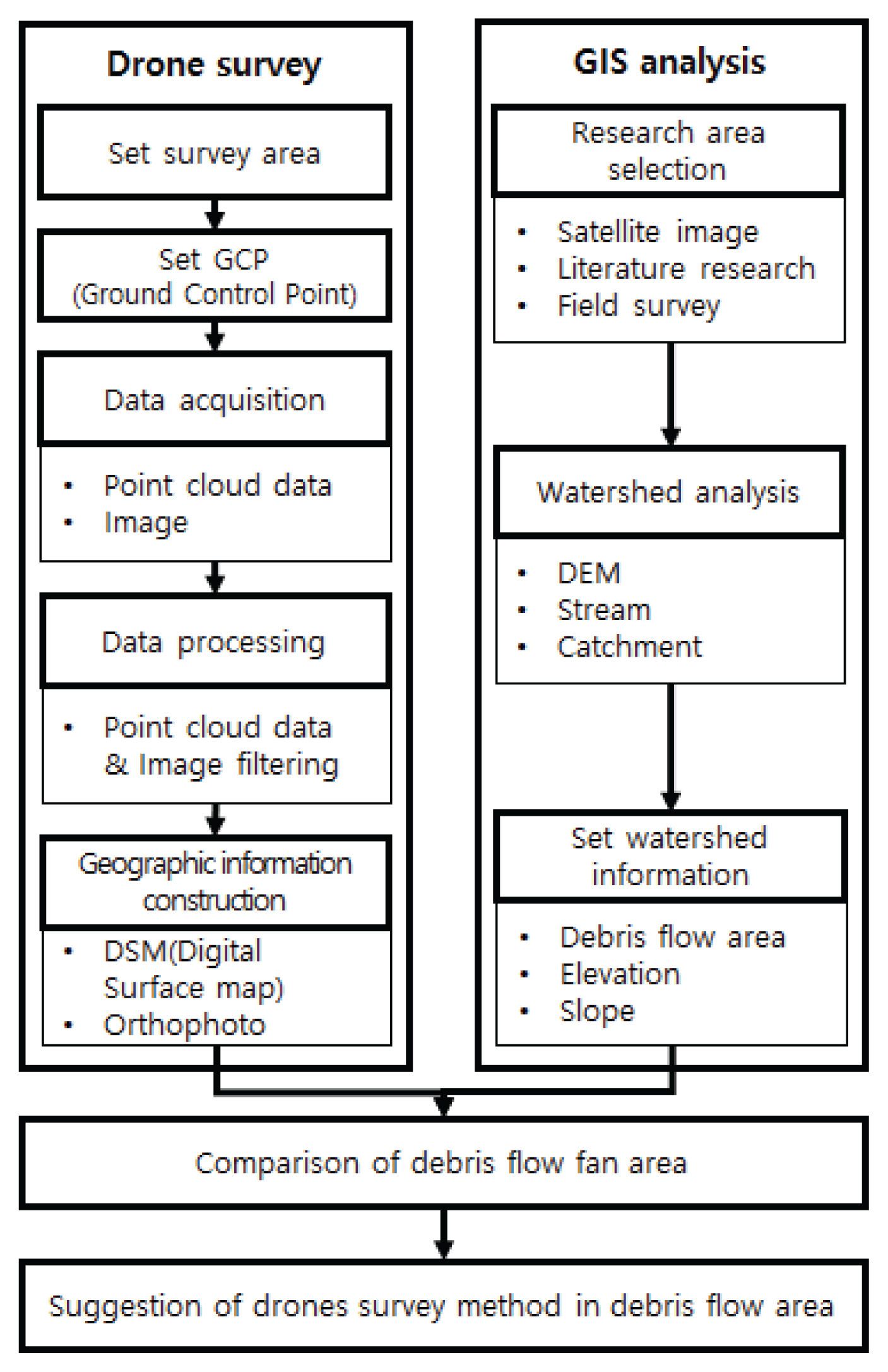
Fig. 2는 본 연구를 수행하기 위한 연구 흐름도를 나타낸다. 국토교통부 국토지리정보원에서 제공하는 1:5000의 수치지형도를 이용하여 유역분석을 통해 유역의 면적, 고도, 경사 등의 정보를 GIS를 이용하여 구축하였다. 이후, 드론을 활용한 공간정보를 구축하여 토석류 발생 이후의 지형정보를 비교 분석 하였다. 드론으로 구축한 공간은 유역의 하단부로서, 토석류 퇴적부의 지형변화를 관측하였으며, 드론측량 정보의 정확성을 제시하였다. 본 연구에 사용된 드론 장비는 DJI사에서 제공하는 Inspire2.0 기체를 이용하였다.
2.2 유역정보 구축
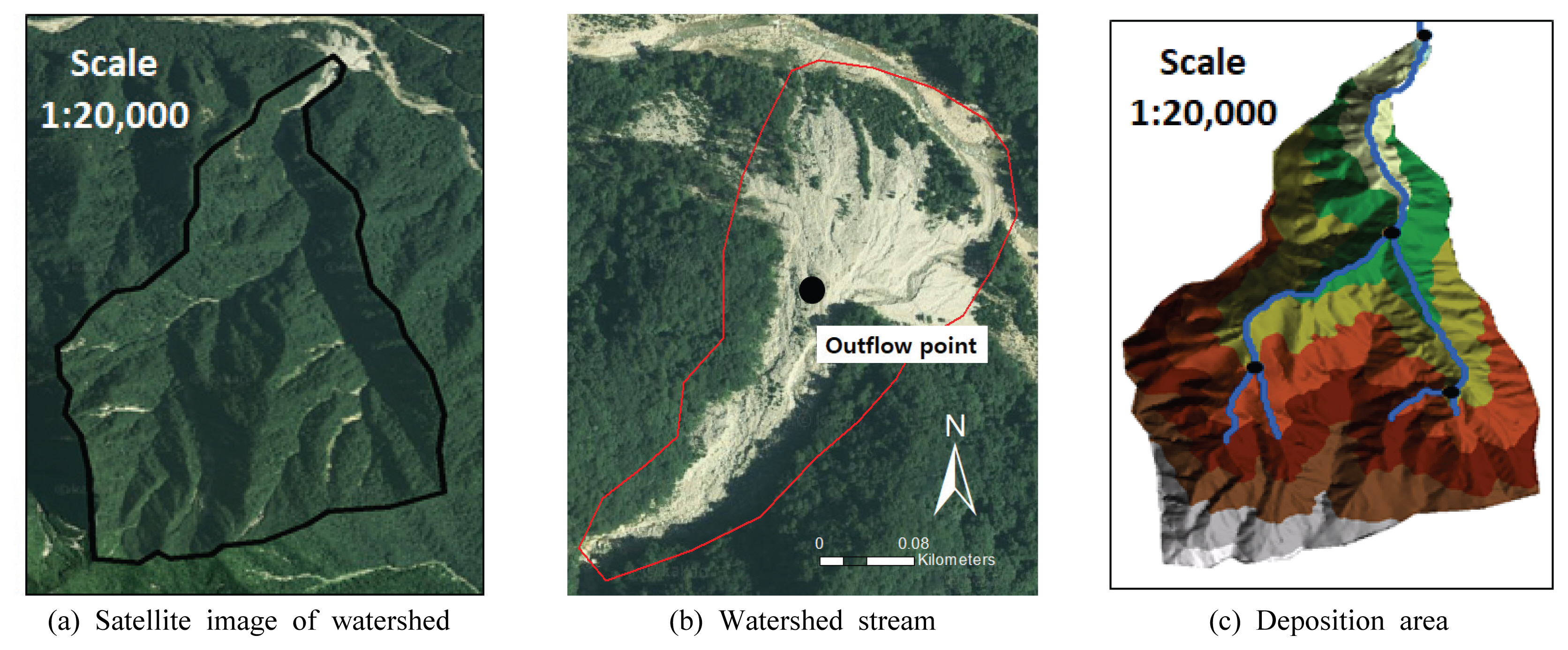
토석류가 발생한 연구지역의 유역 분석을 위하여 위성영상으로 위치를 확인 후, 유출구를 기준으로 상부의 집수유역과 하부의 토석류가 퇴적된 지역을 구분하여 분석하였다(Fig. 3). 유역내 골짜기에서 흐름이 합류하는 지점을 기준으로 토석류의 팬이 시작되는 지점을 유출구의 기준으로 설정하였다(Fig. 3(c)). 이러한 이유는 토석류의 팬 지점의 하단부를 기준으로 유출구를 설정할 경우, 집수유역이 중계천 상부로 확대되어 토석류와 관계없는 유역이 산정되기 때문이다. 유역의 면적은 1.98 km2로 항아리 모양의 집수형태를 나타내고 있다. 최대고도는 1,485 m, 최소고도는 528 m, 평균고도는 979 m로서, 2 km정도의 짧은 유역길이에 비하여 고도차이가 약 1 km가 차이가 있음에 따라 매우 경사가 급한 지형으로 평균경사는 39.3°를 나타냈다. 계류의 최대 길이는 약 2.8 km로 나타났고, 유출구로부터 상부 1 km에 합류부 상부의 두 개의 큰 골짜기로 나누어짐을 확인하였다(Table 1). 실제 현장조사 결과 유출구로부터 상부 1 km지점까지는 상시흐름이 발생하였고, 합류부로부터 두 갈래로 갈라지는 계류는 홍수기에 흐름이 발생하는 것으로 확인하였다.
2.3 고해상도 공간정보 구축
드론을 이용한 고해상도 공간정보를 구축하기 위하여 Fig. 2와 같은 순서에 따라 조사를 수행하였다. 연구지역은 설악산 국립공원 내에 위치하고 있기 때문에 관할 기관인 설악산 국립공원관리공단의 허가를 받아 드론의 항로계획을 설정하였다. 토석류의 퇴적이 발생한 지형을 중심으로 62,000 m2의 면적에 대하여 촬영계획을 수립하였다.
공간촬영을 수행하기 이전에 지형정보의 절대좌표를 획득하기 위하여 지상기준점(Ground Control Point, GCP)을 선정하여 측량을 수행하였다. 24개소의 기준점을 선정하여 좌표를 취득하였고 4개의 기지점(Check Point, CP)에 대하여 비교하여 오차율을 확인하였다. 오차율은 정밀도를 표현하는데 적합한 평균 제곱근 오차(Root Mean Square Deviation, RMSE)를 이용하였다. RMSE의 값이 x축 방향 0.021 m,y축 방향 0.031 m, z축 방향 0.028 m로 나타났다(Table 2).
획득된 드론영상은 PIX4D Mapper 소프트웨어를 사용하여 연구지역 이외의 필요 없는 Point Cloud Data를 제거하고, 1401장의 촬영된 이미지를 중첩하여 정사영상을 생성하고, 최종적으로 0.79 cm의 샘플링 거리를 갖는 DSM을 생성하였다(Fig. 4).
3. 결과 및 분석
연구지역에 토석류가 발생하여 주로 퇴적이 발생하는 유출구 주변의 유역 하단부에 대하여 1:5000 수치지형도의 DEM과 드론으로 측량하여 도출한 DSM의 지형을 비교분석하였다. 유출구를 중심으로 하단부인 토석류의 팬 부분의 면적은 30,000 m2으로 나타났으며, 상단부인 일부 계류의 면적은 34,000 m2으로 나타났다.
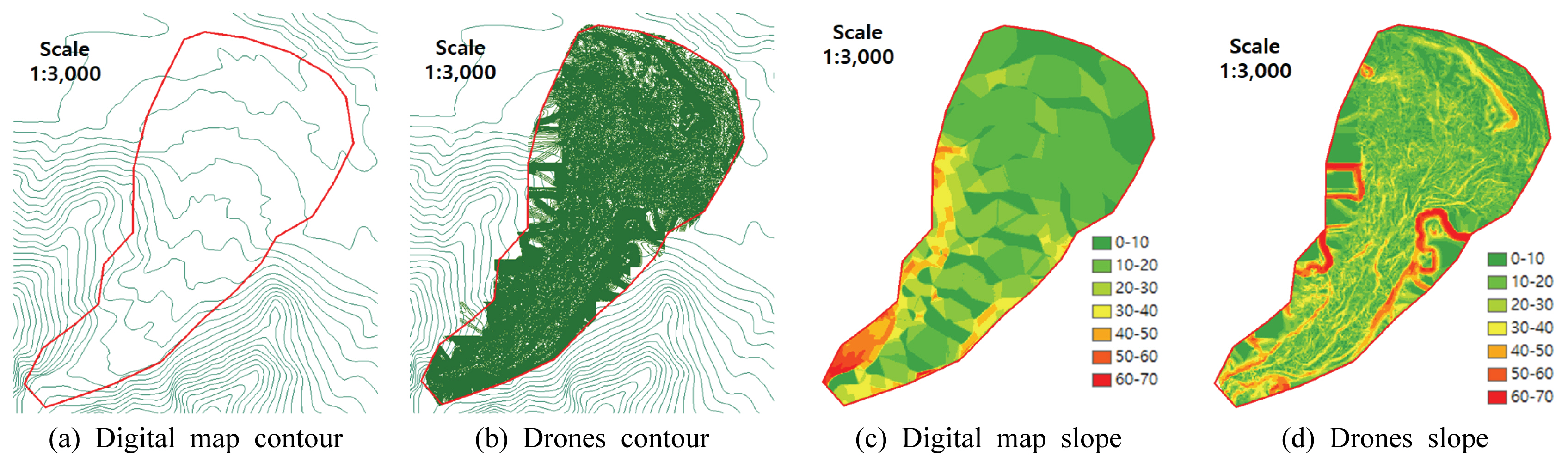
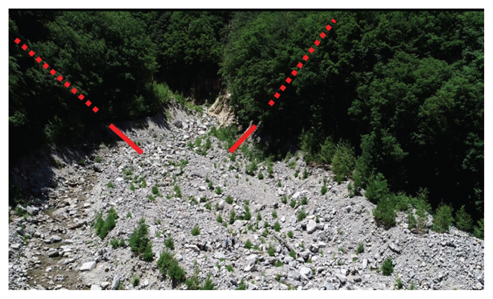
Figs. 5(a), (b)는 수치지형도의 등고선과 DSM의 등고선을 각각 나타내고 있다. 2017년도에 제작된 1:5000의 수치지형도를 국토교통부 국토지리정보원으로부터 제공받아 계곡선과 주곡선의 추출을 통하여 등고선을 나타내었다. 주곡선 사이의 길이는 5 m로써, 토석류가 흘러내린 계류부분이 나타나는 것을 확인하였다. DSM의 등고선의 경우 0.1 m단위로 제작하여 수치지형도에 비하여 상대적으로 등고선 간격이 매우 짧아 계류부의 시각적 구분은 어려웠으나 지형의 고도값을 상세하게 나타내었다. 제작된 등고선을 이용하여 1 m; × 1 m의 격자로 구분하여 경사도 분석을 하였다(Figs. 5(c), (d)). 수치지형도에서는 평균 경사도가 10.6°로 나타났으며 DSM에서는 평균 경사도가 14.1°로 나타났다. Fig. 5(d)는 DSM에서 분석한 경사도로써, 계류부분을 따라 경사가 높고 낮음의 분포가 다양하며, 수치지형도에 비하여 복잡한 형태의 경사 분포를 나타내고 있다. 하지만 유출구를 지점으로 양 옆의 사면은 60°~70°의 경사를 나타내고 있으며 이는 토석류가 흘러내린 사면의 일부를 반영하고 있으나 식생의 Point data 정보를 담고 있는 것으로 판단하였다. Fig. 6은 이러한 정보를 나타내고 있으며, DMS에서 오차가 발생한 부분의 단면을 표시하였다. 실선은 지표면을 의미하고 점선은 식생의 고도 값을 나타낸 사면을 의미한다. DSM을 제작하기 위하여 토석류가 흘러내린 지형 부분과 식생의 고도값이 포함된 사면의 구분이 반드시 필요하며 생성된 DSM은 현장 정보의 확인을 통해 검증이 필요하다.
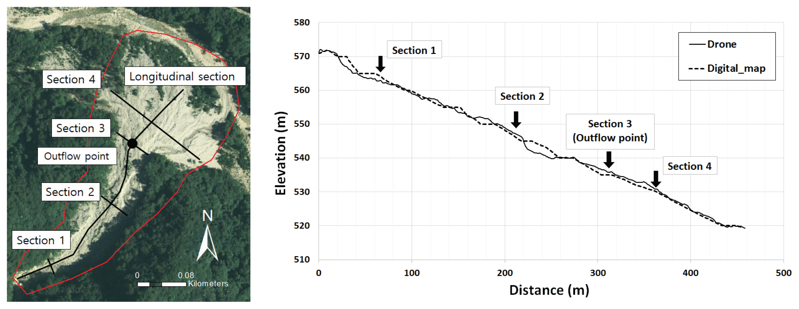
Fig. 7은 수치지형도와 DSM의 지형정보 비교를 위하여 횡단면도와 종단면도의 위치를 나타낸다. 종단면의 경우 계류의 중심을 따라 토석류 확산 지점까지 약 450 m를 추출하였으며, DSM은 실선, 수치지형도는 점선으로 나타냈다. 횡단면도는 종단면도의 유출구를 기준으로 하여 상부의 250 m지점(1번 단면), 100 m지점(2번 단면), 유출구지점(3번 단면), 유출구로부터 하부의 50 m지점(4번 단면) 을 기준으로 하여 종단면에 직각하는 단면을 추출하였다. 총 4개의 단면에 대하여 수치지형도와 DSM의 고도값을 비교하였다(Fig. 7). Fig. 8(a)는 1번 단면으로 폭 18 m의 계류부를 나타내고 있다. 수치지형도는 평균 고도가 568 m로 나타났고 변화의 폭이 1 m정도로 단면의 길이에 따른 고도의 변화차이가 크게 나타나지 않았다. DSM의 경우, 평균 고도는 570 m로 나타났고, 단면의 중심부 지점인 계류부가 567 m로 가장 낮은지점, 좌안이 572 m로 가장 높은 지점으로 나타났다.
Fig. 8(b)는 2번 단면으로, 수치지형도와 DSM의 평균 고도가 555 m로 나타났다. 하지만, DSM에서는 계류 중심부에 폭 10 m 높이 1.5 m정도의 퇴적된 토사로 인한 지형을 반영하는 것으로 나타났다. Fig. 8(c)는 유출구의 지점인 3번 단면으로, 수치지형도와 DSM의 평균 고도가 모두 532 m로 나타났다. 흐름이 형성되어 있는 우안의 50~70 m지점은 수치지형도와 DSM의 침식에 대한 부분이 모두 지형의 변화가 반영된 것으로 나타났으나, 좌안의 0~20 m지점의 상시흐름이 형성되어있어 있는 지점에서는 수치지형도에서는 반영하지 못하였다. DSM에서는 이러한 부분이 반영되어 있으며, 침식의 깊이는 약 1.5 m로 나타났다. Fig. 8(d)는 토석류의 팬 부분을 나타내고 있으며, 단면의 길이가 약 220 m로 나타났다. 평균 고도는 수치지형도와 DSM 모두 526 m로 나타나 비슷한 형상을 하고 있으나 상시흐름이 있는 좌안의 50 m지점과 우안의 130 m지점에서는 침식이 발생하여 약 2.5 m의 고도차가 발생하였다.
수치지형도와 드론으로 구축한 각각의 DEM과 DSM의 평균적인 고도는 비슷하게 나타났으나 계류에 의한 침식이 발생한 지점에 대하여 DSM은 구체적으로 반영하였다. 침식의 평균 높이는 약 1.5 m로 나타났으며, 침식높이의 최저점과 고도의 최고점의 차이를 구하여 평균 퇴적 높이는 약 2.5 m로 추정하였다. 유출구 이후의 확산면적 35,000 m3과 추정되는 평균 퇴적 높이인 2.5 m높이를 계산하여 2006년 연구지역에서 발생한 토석류 유출구 아래 확산부의 퇴적량은 약 75,000 m3으로 추정하였다.
4. 결 론
본 연구에서는 드론을 이용하여 토석류 발생지역의 고해상도 공간정보를 구축하고 수치지형도와 비교하여 지형특성을 분석하였다.
1:5000 수치지형도의 DEM과 드론으로 구축한 DSM의 비교결과 토석류 퇴적부의 경사도는 약 3°의 차이가 발생하였다. 또한 토석류 확산부의 평균고도는 비슷하게 나타났으나, 유출구 상부의 계류부분에서 약 3 m의 차이가 발생하였다. 확산부에서는 상시 흐름이 발생하는 지점에서 약 1.5 m의 침식 높이가 나타난 것을 DSM을 통해 확인하였다. 침식깊이의 최저점과, 고도의 최고점을 이용하여 퇴적심도는 약 2.5 m로 추정하여 유출구 아래의 토석류 확산부에 대하여 퇴적량은 약 75,000 m2으로 추정하였다.
본 연구 방법을 이용하여 드론을 이용하여 고해상도 지형공간정보 구축을 통한 토석류의 지형변화의 관측이 가능하며, 향후 토석류가 발생하기 전, 후의 고해상도자료의 비교를 통해 정확한 침식과 퇴적량을 산정할 수 있을 것으로 기대한다.