1. ņä£ ļĪĀ
ņé░ņé¼Ēā£ļ×Ć Ļ░ĢņÜ░ļéś ņ¦Ćņ¦äņ£╝ļĪ£ ņØĖĒĢ┤ ĒØÖņØ┤ļéś ņĢöņäØņØ┤ ĻĘĀĒśĢņØä ņ×āĻ│Ā ņżæļĀź ņ×æņÜ®ņŚÉ ņØśĒĢśņŚ¼ ļ¼┤ļäłņĀĖ ļé┤ļ”¼ļŖö ĒśäņāüņØä ņØśļ»ĖĒĢśļ®░, ĒåĀņäØļźśļŖö ņé░ņé¼Ēā£ ļō▒Ļ│╝ Ļ░ÖņØĆ ļČĢĻ┤┤ļĪ£ ņØĖĒĢśņŚ¼ ļ¼┤ļäłņ¦ä ĒØÖ, ļ░öņ£ä, ņ£Āļ¬® ļō▒ņØ┤ Ļ│äĻ│ĪņØä ļö░ļØ╝ ĒĢśļźśļČĆļĪ£ ņØ╝ņŗ£ņŚÉ ĒØÉļź┤ļŖö Ēśäņāüņ£╝ļĪ£, ņŻ╝ļĪ£ ņןļ¦łņ▓ĀĻ│╝ Ēā£ĒÆŹņØ┤ ņ¦ĆļéśĻ░ĆļŖö ņŚ¼ļ”äņ▓ĀņŚÉ ņ¦æņżæņĀüņ£╝ļĪ£ ļ░£ņāØĒĢśĻ│Ā ņ׳ļŗż.
ņĄ£ĻĘ╝ ņĀä ņäĖĻ│äņĀüņ£╝ļĪ£ļ┐É ļ¦īņĢäļŗłļØ╝ ņÜ░ļ”¼ļéśļØ╝ņŚÉļÅä ņØ┤ņāüĻĖ░ĒøäļĪ£ ņØĖĒĢ┤ ĻĄŁņ¦Ćņä▒ ņ¦æņżæĒśĖņÜ░ ļ░Å Ēā£ĒÆŹņØś Ēö╝ĒĢ┤Ļ░Ć ļ╣łļ▓łĒĢ┤ņ¦Ćļ®┤ņä£ ĒåĀņäØļźś Ēö╝ĒĢ┤Ļ░Ć ņ×”Ļ▓ī ļ░£ņāØĒĢśĻ│Ā ņ׳ņ£╝ļ®░, ņØ┤ļĪ£ ņØĖĒĢ┤ ņØĖļ¬ģ ļ░Å ņ×¼ņé░Ēö╝ĒĢ┤ļÅä Ēü¼Ļ▓ī ļ░£ņāØĒĢśĻ│Ā ņ׳ļŖö ņČöņäĖņØ┤ļŗż. ĒåĀņäØļźśļŖö Ļ│äĻ│ĪņØä ļö░ļØ╝ ĒĢśļźśļČĆļĪ£ ņ£ĀĒĢśĒĢśņŚ¼ ĒĢśļČĆņ¦ĆņŚŁņŚÉ ļČäĒżĒĢśļŖö ņŗ£ņäżļ¼╝ņŚÉ Ēö╝ĒĢ┤ļź╝ ļ░£ņāØņŗ£Ēéżļ®░, Ēö╝ĒĢ┤ļ▓öņ£äļŖö ņŻ╝Ļ▒░ņ¦Ć ļ░Å Ļ│ĄĻ│Ąņŗ£ņäż, ļåŹĻ▓Įņ¦Ć ļō▒ ļŗżņ¢æĒĢ£ ĒśĢĒā£ļĪ£ ļ░£ņāØļÉśĻĖ░ ļĢīļ¼ĖņŚÉ ņé¼ĒÜīŌŗģĻ▓ĮņĀ£ņĀü Ēö╝ĒĢ┤ļŖö Ļ┤æļ▓öņ£äĒĢśĻ▓ī ļéśĒāĆļé£ļŗż. ņØ┤ļ¤¼ĒĢ£ ĒåĀņäØļźś Ēö╝ĒĢ┤ļź╝ ņĀĆĻ░ÉĒĢśĻĖ░ ņ£äĒĢ┤ņä£ ņé░ļ”╝ņ▓Ł, ĒĢ£ĻĄŁņ¦Ćņ¦łņ×ÉņøÉņŚ░ĻĄ¼ņøÉ, ĻĄŁļ”Įņ×¼ļé£ņĢłņĀäņŚ░ĻĄ¼ņøÉ ļō▒ņŚÉņä£ļŖö ņ¦ĆĒśĢ ļ░Å ņ¦Ćļ░śĒŖ╣ņä▒ ļō▒ņØ┤ Ļ│ĀļĀżļÉ£ GISĻĖ░ļ░ś ņé░ņé¼Ēā£ ņ£äĒŚśņ¦ĆļÅäļź╝ ņ×æņä▒ĒĢśņŚ¼ ņä£ļ╣äņŖż ņżæņŚÉ ņ׳ņ£╝ļ®░, ĻĄŁļ”Įņ×¼ļé£ņĢłņĀäņŚ░ĻĄ¼ņøÉņŚÉņä£ļŖö ĻĖēĻ▓Įņé¼ņ¦Ć ļČĢĻ┤┤Ļ▓Įļ│┤ ļ░Å ļīĆĒö╝ĻĖ░ņżĆ ņäżņĀĢņŚÉ ļīĆĒĢ£ ņŚ░ĻĄ¼Ļ░Ć ĒÖ£ļ░£ĒĢśĻ▓ī ņ¦äĒ¢ē ņżæņØ┤ļŗż(National Institute of Disaster and Safety, 2004; Korea Forest Service, 2006; KIGAM, 2009).
ĻĄŁļé┤ņÖĖ ņé░ņé¼Ēā£ ļ░Å ĒåĀņäØļźś ņ£äĒŚśņä▒ ĒÅēĻ░Ć ļ░Å ņ£äĒŚśņ¦ĆļÅä ņ×æņä▒ņŚÉ Ļ┤ĆĒĢ£ ņŚ░ĻĄ¼ļÅÖĒ¢źņØä ņé┤ĒÄ┤ļ│┤ļ®┤ ĻĄŁņÖĖņØś Ļ▓ĮņÜ░ GIS ĻĖ░ņłĀņØä ņØ┤ņÜ®ĒĢśņŚ¼ ļ¼┤ĒĢ£ĒÅēļ®┤ņé¼ļ®┤ņĢłņĀĢļ¬©ļŹĖņØä ĒåĄĒĢ┤ ņé¼ļ®┤ņØś Ļ▓Įņé¼ņÖĆ ņ¦æņłśņ¦ĆņŚŁņØä ĻĖ░ļ░śņ£╝ļĪ£ ĒĢśļŖö ņé¼ļ®┤ņĢłņĀĢļō▒ĻĖēņØä ņĀĢņØśĒĢ£ ļ░ö ņ׳ņ£╝ļ®░(Montgomery and Dietrich, 1994), ļ¼┤ĒĢ£ĒÅēļ®┤ņé¼ļ®┤ņĢłņĀĢļ¬©ļŹĖņŚÉ ļÅÖņĀüņØĖ ņłśļ”¼ ļ¬©ļŹĖļ¦üņØä ņĀæĒĢ®ņŗ£Ēé© ļŹöņÜ▒ ņĀĢĻĄÉĒĢ£ ļ¬©ļŹĖņØä ņĀ£ņŗ£ĒĢśĻ│Ā(Wu and Sidle, 1995), ņłśļ”¼ņĀü ļ¬©ļŹĖņØä ļ¼┤ĒĢ£ĒÅēļ®┤ņé¼ļ®┤ņĢłņĀĢļ¬©ļŹĖĻ│╝ Ļ▓░ĒĢ®ĒĢśņŚ¼ ņé¼ļ®┤ ņĢłņĀĢ ļČäņäØņØä ņ£äĒĢ£ SINMAPņØä Ļ░£ļ░£ĒĢśņśĆļŗż(Pack, 1995). ļśÉĒĢ£ ĒåĀņäØļźś ļ░£ņāØ ņśüĒ¢źņØĖņ×ÉņØĖ ļ¬©ņĢöņØś ņóģļźś, ĻĖ░ļ░śņĢö ļé┤ļŗ©ņĖĄņØś ĻĖĖņØ┤, ņé¼ļ®┤ĒīīĻ┤┤ ļ®┤ņĀü, ņé¼ļ®┤ Ļ▓Įņé¼, ņé¼ļ®┤ ļ░®Ē¢ź, Ļ│äĻ│ĪļČĆ Ļ▓Įņé¼, ņ£ĀņŚŁ ļ®┤ņĀü, form factor, C factorļź╝ ņäĀĒāØĒĢśņŚ¼ GISļź╝ ņØ┤ņÜ®ĒĢśņŚ¼ ĒåĀņäØļźś ļ░£ņāØ ņ£äĒŚśļÅäļź╝ ņśłņĖĪĒĢśņśĆņ£╝ļ®░(Lin et al., 2002), ņé░Ļ░äņ¦Ćļ░®ņØś ņ¦ĆņŚŁļ│ä ņ¦ĆĒśĢ ļ░Å ņ¦Ćņ¦łņĀĢļ│┤ļź╝ ņżæņŗ¼ņ£╝ļĪ£ ļĪ£ņ¦ĆņŖżĒŗ▒ ĒÜīĻĘĆļČäņäØņØä ņłśĒ¢ēĒĢśņŚ¼ ņé░ņé¼Ēā£ ņśüĒ¢źņØĖņ×Éļź╝ Ļ▓░ņĀĢĒĢśĻ│Ā, ņØĖņ×Éļ│ä ļČäņäØ Ļ│äņłśļź╝ ņĀ£ņŗ£ĒĢśņŚ¼ ņé░ņé¼Ēā£ ņ£äĒŚśņ¦ĆļÅäļź╝ ņ×æņä▒ĒĢ£ ļ░ö ņ׳ņ£╝ļ®░(Ayalew et al., 2004), Deb and El-kadi (2009)ļŖö SINMAPĻ│╝ ņłśļ¼ĖĒĢÖņĀü ļ¬©ĒśĢņØä ņØ┤ņÜ®ĒĢśņŚ¼ ņé░ņé¼Ēā£ņØś ļ»╝Ļ░Éņä▒ ĒÅēĻ░Ćļź╝ ņŗżņŗ£ĒĢśņśĆļŗż.
ĻĄŁļé┤ņØś Ļ▓ĮņÜ░ ĻĖłĒśĖĻ░Ģ ņ£ĀņŚŁņØä ļīĆņāüņ£╝ļĪ£ ņé░ņé¼Ēā£ ļ░£ņāØņŚÉ ņśüĒ¢źņØä ļ»Ėņ╣śļŖö ĒÖśĻ▓ĮņØĖņ×ÉļōżņØä ņČöņČ£ĒĢśĻ│Ā GISņÖĆ ņøÉĻ▓®ĒāÉņé¼ ĻĖ░ļ▓ĢņØä ĒÖ£ņÜ®ĒĢśņŚ¼ Ļ░ü ņØĖņ×Éļź╝ ļ¦żĒŖĖļ”ŁņŖż ļ░®ļ▓ĢņØä ņØ┤ņÜ®ĒĢśņŚ¼ ņé░ņé¼Ēā£ ņĘ©ņĢĮņä▒ ņ¦ĆļÅäļź╝ ņ×æņä▒ĒĢ£ ļ░ö ņ׳ņ£╝ļ®░(Kim et al., 2005), 596Ļ░£ņØś ņé░ņé¼Ēā£ ļ░£ņāØņØ┤ļĀź ņ×ÉļŻīņÖĆ ņé░ņé¼Ēā£ ļ░£ņāØņÜöņØĖ ņĀĢļ│┤ļź╝ ĻĖ░ņ┤łļĪ£ ņé░ņé¼Ēā£ ļ░£ņāØĻ│╝ ļ░£ņāØņÜöņØĖ Ļ░äņØś ņāüĻ┤ĆĻ┤ĆĻ│äļź╝ ļČäņäØĒĢśĻ│Ā ļČäņäØ Ļ▓░Ļ│╝ļź╝ ĒåĄĒĢ┤ Ļ░Ćņżæņ╣ś ļ░Å ņ£äĒŚśļÅä ņØĖļŹ▒ņŖżļź╝ ĒåĄĒĢ┤ ņé░ņé¼Ēā£ ņ£äĒŚśņ¦ĆļÅäļź╝ ņ×æņä▒ĒĢ£ ļ░ö ņ׳ņ£╝ļ®░(Yun et al., 2009), ĒåĀņäØļźś ļ░£ņāØņ¦ĆņŚŁņŚÉ ļīĆĒĢ£ ņ£äĒŚśņä▒ ļČäņäØņØä ņ£äĒĢ┤ ĒåĄĻ│äņĀü ĻĖ░ļ▓ĢĻ│╝ Ļ▓░ņĀĢļĪĀņĀü ĻĖ░ļ▓ĢņØä ņØ┤ņÜ®ĒĢśņŚ¼ GIS ĻĖ░ļ▓ĢņØä ĒåĄĒĢ┤ ņ×¼ĒĢ┤ņ£äĒŚśņ¦ĆļÅäļź╝ ņ×æņä▒ĒĢśņśĆļŗż(Jun and Oh, 2011).
Lee (2016)ļŖö ņČśņ▓£ņ¦ĆņŚŁņØä ļīĆņāüņ£╝ļĪ£ Ļ░ĢņÜ░ļ¤ēņĪ░ņé¼ņÖĆ ņŻ╝ļ│ĆņØś ņ¦ĆĒśĢ, ņłśļ¼Ė, ĒåĀņ¢æ, ņ¦Ćņ¦łņÜöņØĖļōżņØä ņØ┤ņÜ®ĒĢśņŚ¼ GISļź╝ ĒÖ£ņÜ®ĒĢ£ WOEļ¬©ļŹĖ ĻĖ░ļ▓ĢņØä ņĀüņÜ®ĒĢśņŚ¼ ņé░ņé¼Ēā£Ļ░Ć ļ░£ņāØĒĢĀ ĒÖĢļźĀņØ┤ ļåÆņØĆ ņ¦ĆņŚŁņØä ņäĀņĀĢĒĢśĻ│Ā SINMAPņØä ĒåĄĒĢśņŚ¼ ĒåĀņäØļźś ņ£äĒŚśņ¦ĆļÅäļź╝ ņ×æņä▒ĒĢśņśĆņ£╝ļ®░ ĒåĀņäØļźś ņŗ£ļ«¼ļĀłņØ┤ņģś ļ¬©ļŹĖņØĖ Flo-2Dļź╝ ĒÖ£ņÜ®ĒĢśņŚ¼ ļ¼╝ļ”¼ĒĢÖņĀü Ēö╝ĒĢ┤ ņ¦Ćņłś ņżæ Ļ▒┤ļ¼╝ņŚÉ ļīĆĒĢ£ ļ”¼ņŖżĒü¼ļź╝ ĒÅēĻ░ĆĒĢśņśĆļŗż.
ĻĘĖ ļ░¢ņŚÉļÅä ļ¦ÄņØĆ ņŚ░ĻĄ¼ņ×ÉļōżņØ┤ ĒåĀņé¼ņ×¼ĒĢ┤ņÖĆ Ļ┤ĆļĀ©ļÉ£ ļ¦ÄņØĆ ņŚ░ĻĄ¼ļź╝ ņ¦äĒ¢ēĒĢśĻ│Ā ņ׳ņ£╝ļéś, ļīĆļČĆļČäņØś ņé░ņé¼Ēā£ ļ░Å ĒåĀņäØļźś ņ£äĒŚśņ¦ĆļÅäļŖö Ēö╝ĒĢ┤ļź╝ ņ£Āļ░£ĒĢśļŖö Ļ░ĢņÜ░ļéś ĒĢśļČĆņŚÉ ņ£äņ╣śĒĢ£ ņŗ£ņäżļ¼╝ļōżņØä Ļ│ĀļĀżĒĢśņ¦Ć ņĢŖņ£╝ļ®░, ņŻ╝ļĪ£ Ļ▓Įņé¼ļÅäļź╝ ņØ┤ņÜ®ĒĢśņŚ¼ ļ░£ņāØņ£äņ╣śļź╝ ņśłņĖĪĒĢśĻ▒░ļéś ņ£äĒŚśņ¦ĆņŚŁņØä ņäĀņĀĢĒĢśļ®░, Ēö╝ĒĢ┤ņ¦ĆņŚŁņØś ņŗ£ļ«¼ļĀłņØ┤ņģśņØä ĒåĄĒĢ┤ ņ£äĒŚśņä▒ņØä ĒÅēĻ░ĆĒĢśĻ▒░ļéś Ļ│äņĖĪņØä ĒåĄĒĢ┤ ņØ┤ņāü ņ¦ĢĒøäĻ░Ć ļ░£Ļ▓¼ļÉśņŚłņØä ļĢī ņ×æļÅÖļÉśļŖö ņśłŌŗģĻ▓Įļ│┤ņŗ£ņŖżĒģ£ ļśÉļŖö ļīĆĒö╝ ĻĖ░ņżĆņØä ņäĀņĀĢĒĢśļŖöļŹ░ ņ¦æņżæļÉśņ¢┤ ņÖöļŗż(Choi et al., 2012).
ļö░ļØ╝ņä£ ļ│Ė ņŚ░ĻĄ¼ņŚÉņä£ļŖö 2011ļģäņŚÉ ļ░£ņāØĒ¢łļŹś ņä£ņÜĖņŗ£ ņÜ░ļ®┤ņé░Ļ│╝ ņČśņ▓£ņŗ£ ļ¦łņĀüņé░ņØä ļīĆņāüņ£╝ļĪ£ ĒåĀņäØļźśļź╝ ņ£Āļ░£ĒĢśļŖö Ļ░ĢņÜ░ļź╝ Ļ│ĀļĀżĒĢśĻĖ░ ņ£äĒĢśņŚ¼ ņ¦ĆņåŹņŗ£Ļ░ä 9ņŗ£Ļ░äņØś ļ╣łļÅäļ│ä ĒÖĢļźĀĻ░ĢņÜ░ļ¤ē(30ļģä, 100ļģä, 200ļģä)ņØä ņØ┤ņÜ®ĒĢśņŚ¼ ļČäĒżĒśĢ Ļ░ĢņÜ░-ņ£ĀņČ£ļ¬©ĒśĢņØĖ S-RATņŚÉ ņĀüņÜ®ĒĢśņŚ¼ ĒåĀņé¼ņ£ĀņČ£ļ¬©ĒśĢ RAMMSņØś ņ×ģļĀźņ×ÉļŻīņØĖ ņ▓©ļæÉĒÖŹņłśļ¤ēĻ│╝ ņ£ĀņČ£ņ┤Øļ¤ēņØä ņé░ņĀĢĒĢśņśĆļŗż. ņé░ņĀĢļÉ£ ņ▓©ļæÉĒÖŹņłśļ¤ēĻ│╝ ņ£ĀņČ£ņ┤Øļ¤ēņØä RAMMSļ¬©ĒśĢņŚÉ ņĀüņÜ®ĒĢśņŚ¼ ļ╣łļÅäļ│ä ĒåĀņäØņ£ĀļÅÖņŗ¼(H), ĒåĀņäØņ£ĀņåŹ(V)ņØä ņé░ņĀĢĒĢśņśĆņ£╝ļ®░, ņØ┤ļź╝ ĒåĄĒĢ┤ ĒåĀņäØļźś ņ£äĒĢ┤ņä▒ņ¦ĆļÅäļź╝ ņ×æņä▒ĒĢśĻ│Ā, ĻĄŁĒåĀĻĄÉĒåĄļČĆņØś ņÜ®ļÅäļ│ä Ļ▒┤ņČĢļ¼╝ņØś ņóģļźś(MOLIT, 2017)ņŚÉ ļö░ļØ╝ ĒĢśļČĆņØś ņŗ£ņäżļ¼╝ļ│ä ņżæņÜöļÅäļĪ£ ļČäļźśĒĢśņŚ¼ ņśüĒ¢źņżæņÜöļÅäņ¦ĆļÅäļź╝ ņ×æņä▒ĒĢśņśĆļŗż. ļśÉĒĢ£ ņ×æņä▒ļÉ£ ĒåĀņäØļźś ņ£äĒĢ┤ņä▒ņ¦ĆļÅäņÖĆ ņśüĒ¢źņżæņÜöļÅäņ¦ĆļÅäļź╝ ņ£äĒŚśļÅä ļ¦żĒŖĖļ”ŁņŖżņŚÉ ņĀüņÜ®ĒĢśņŚ¼, ņĄ£ņóģņĀüņ£╝ļĪ£ ĒåĀņäØļźś ņ£äĒŚśņśüĒ¢źņ¦ĆļÅäļź╝ ņ×æņä▒ĒĢśņśĆļŗż.
2. ņŚ░ĻĄ¼ņ¦ĆņŚŁ ļ░Å ņ×ÉļŻīņłśņ¦æ
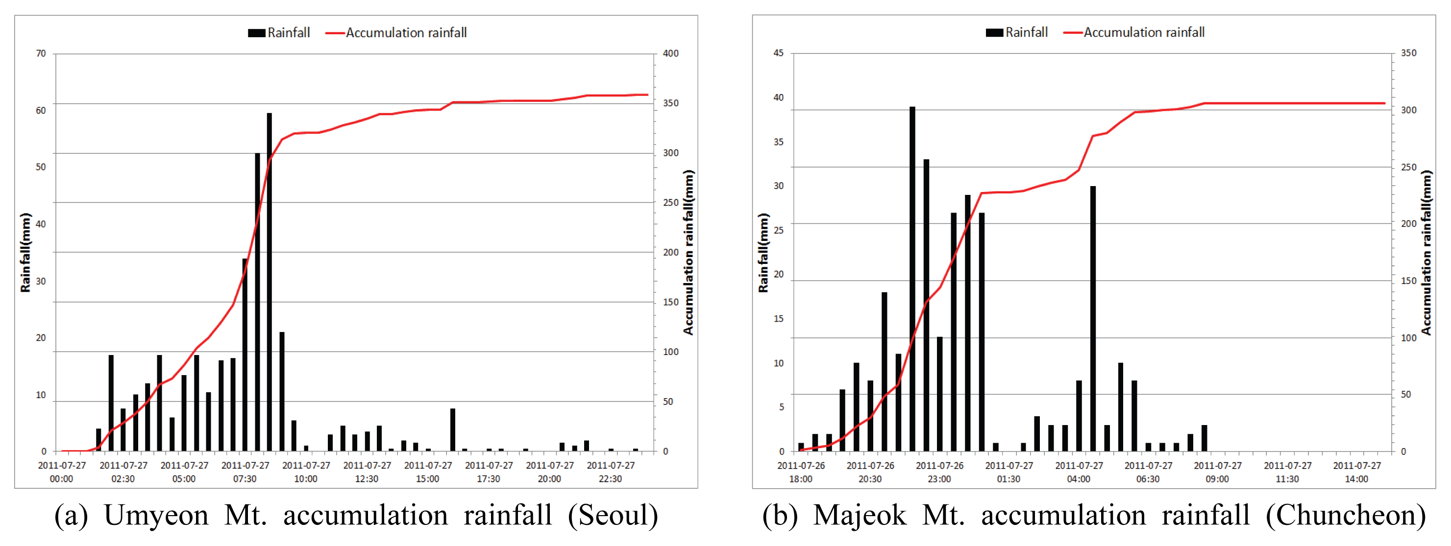
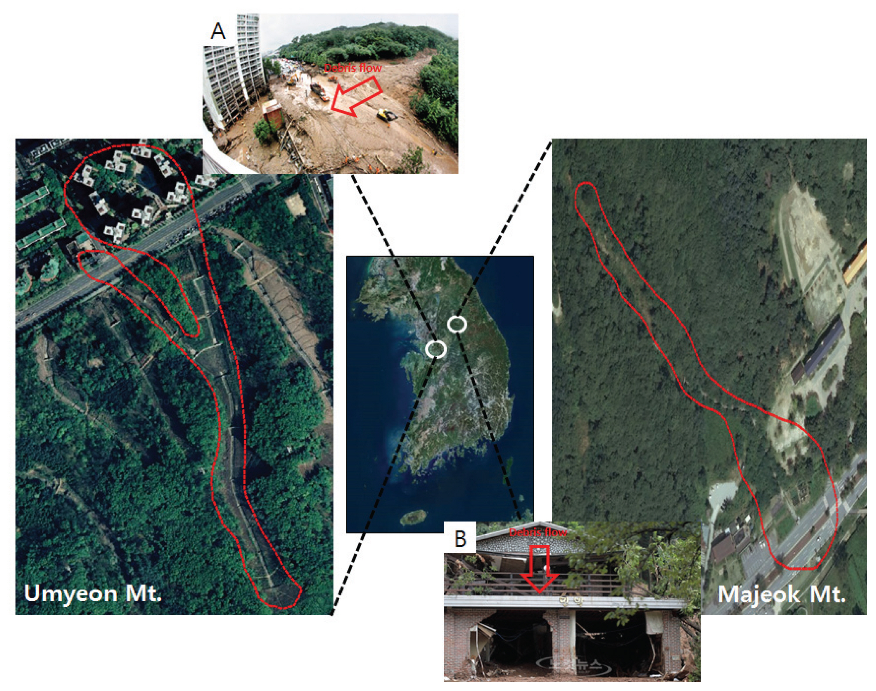
ņÜ░ļ”¼ļéśļØ╝ņØś ĒåĀņé¼ņ×¼ĒĢ┤ļŖö 6ņøöļČĆĒä░ 9ņøö ņŚ¼ļ”äņ▓ĀņØś Ēā£ĒÆŹ ļ░Å ņ¦æņżæĒśĖņÜ░ļĪ£ ņØĖĒĢ┤ ļ░£ņāØĒĢ£ļŗż. 2011ļģä ņä£ņÜĖņŗ£ ņä£ņ┤łĻĄ¼ņŚÉ ņ£äņ╣śĒĢ£ ņÜ░ļ®┤ņé░Ļ│╝ Ļ░ĢņøÉļÅä ņČśņ▓£ņŗ£ņØś ļ¦łņĀüņé░ņŚÉņä£ ļ░£ņāØĒĢ£ ĒåĀņäØļźś Ēö╝ĒĢ┤ ņŚŁņŗ£ 7ņøö ņŚ¼ļ”äņ▓ĀņŚÉ ĻĄŁņ¦Ćņä▒ ņ¦æņżæĒśĖņÜ░ļĪ£ ņØĖĒĢ┤ ļ░£ņāØĒĢ£ Ēö╝ĒĢ┤ņØ┤ļ®░, ņØ┤ļĪ£ ņØĖĒĢ┤ ļ¦ÄņØĆ ņØĖļ¬ģĻ│╝ ņ×¼ņé░ Ēö╝ĒĢ┤Ļ░Ć ļ░£ņāØĒĢśņśĆļŗż.
ņŚ░ĻĄ¼ ņ¦ĆņŚŁņØĆ ņä£ņÜĖņŗ£ ņä£ņ┤łĻĄ¼ ņÜ░ļ®┤ņé░ ņØ╝ļīĆ ņżæņŚÉ Ļ░Ćņן ļ¦ÄņØĆ Ēö╝ĒĢ┤Ļ░Ć ļ░£ņāØĒ¢łļŹś ļלļ»ĖņĢł ņĢäĒīīĒŖĖ ņØ╝ļīĆņÖĆ Ļ░ĢņøÉļÅä ņČśņ▓£ņŗ£ ļ¦łņĀüņé░ņØś ļ¦ÄņØĆ Ēö╝ĒĢ┤Ļ░Ć ļ░£ņāØĒ¢łļŹś ļ¦łņĀüņé░ ĒĢśļźśļČĆņØś ĒÄ£ņģśĻ│╝ ļ»╝ļ░Ģ ņØ╝ļīĆļź╝ ņäĀņĀĢĒĢśņśĆļŗż. ļŗ╣ņŗ£ ņä£ņÜĖņŗ£ ņä£ņ┤łĻĄ¼ ņÜ░ļ®┤ņé░ ņØ╝ļīĆņØś ļłäņĀüĻ░ĢņÜ░ļ¤ēņØä ņé┤ĒÄ┤ļ│┤ļ®┤ 9ņŗ£Ļ░ä ļÅÖņĢł ņä£ņ┤łĻĄ¼ 281 mm, Ļ░Ģļé©ĻĄ¼ 318 mm, Ļ┤ĆņĢģĻĄ¼ 348 mm, ļé©Ēśä 358 mm, Ļ░ĢņøÉļÅä ņČśņ▓£ņŗ£ņØś Ļ▓ĮņÜ░ ņåīņ¢æ2ĻĄÉ 261 mm, ņ¦Ćņ┤īņ┤łĻĄÉ 257 mm, ņ▓£ņĀäļ”¼ 306 mm ņØ┤ņāü Ļ░ĢņÜ░Ļ░Ć ļ░£ņāØĒĢśņśĆļŗż.
ļ│Ė ļģ╝ļ¼ĖņŚÉņä£ļŖö ņä£ņÜĖņŗ£ ņä£ņ┤łĻĄ¼ ņÜ░ļ®┤ņé░ ņØ╝ļīĆņÖĆ Ļ░ĢņøÉļÅä ņČśņ▓£ņŗ£ ļ¦łņĀüņé░ ņØ╝ļīĆņØś 1:5,000 ņłśņ╣śņ¦ĆļÅäļź╝ ĒÖ£ņÜ®ĒĢśņŚ¼ 5 m ├Ś 5 m Ļ▓®ņ×ÉņØś DEMņØä ņāØņä▒ĒĢśņśĆņ£╝ļ®░ ĒåĀņ¦ĆņØ┤ņÜ®ļÅäņÖĆ ĒåĀņ¢æļÅä ļśÉĒĢ£ ļÅÖņØ╝ĒĢ£ Ēü¼ĻĖ░ļĪ£ ņāØņä▒ĒĢśņŚ¼ S-RAT ļ¬©ĒśĢĻ│╝ RAMMS ļ¬©ĒśĢņŚÉ ņĀüņÜ®ĒĢśņśĆļŗż. Fig. 1ņØĆ ņä£ņÜĖņŗ£ ņÜ░ļ®┤ņé░ ļ░Å ņČśņ▓£ņŗ£ ļ¦łņĀüņé░ņØś ļłäņĀüĻ░ĢņÜ░ļ¤ēņØä ļéśĒāĆļāłņ£╝ļ®░, Fig. 2ļŖö ņŚ░ĻĄ¼ņ¦ĆņŚŁ ļ░Å Ēö╝ĒĢ┤ņé¼ņ¦äņØä ļéśĒāĆļāłļŗż.
3. ņŚ░ĻĄ¼ņ¦ĆņŚŁ ļ░Å ņ×ÉļŻīņłśņ¦æ
ļ│Ė ļģ╝ļ¼ĖņØś ņŚ░ĻĄ¼ĒØÉļ”äļÅäļŖö Fig. 3Ļ│╝ Ļ░Öļŗż. 2011ļģä ņŗżņĀ£ ĒåĀņäØļźśļź╝ ņ£Āļ░£ņŗ£Ēé© Ļ░ĢņÜ░ņ×ÉļŻīņÖĆ ņ¦ĆņåŹņŗ£Ļ░ä 9ņŗ£Ļ░äņØś ļ╣łļÅäļ│ä ĒÖĢļźĀĻ░ĢņÜ░ļ¤ē(30ļģä, 100ļģä, 200ļģä)ņØä ņØ┤ņÜ®ĒĢśņŚ¼ Spatial Runoff Assessment Tool (S-RAT)ļ¬©ĒśĢņŚÉ ņĀüņÜ®ĒĢśņśĆĻ│Ā ĒåĀņé¼ņ£ĀņČ£ļ¬©ĒśĢņØĖ Rapid Mass Move Simulations (RAMMS)ļ¬©ĒśĢņØś ņ×ģļĀźņ×ÉļŻīņØĖ ņ▓©ļæÉĒÖŹņłśļ¤ēĻ│╝ ņ£ĀņČ£ņ┤Øļ¤ēņØä ņé░ņĀĢĒĢśņŚ¼ ņé¼ņÜ®ĒĢśņśĆļŗż. RAMMSļ¬©ĒśĢņØś ņ×ģļĀźņ×ÉļŻīņØĖ ĒåĀņé¼ļ¤ēņØĆ ņØ╝ļ│Ė ĻĄŁĒåĀĻĄÉĒåĄņä▒ņŚÉņä£ ņĀ£ņŗ£ĒĢ£ ĒåĀņé¼ļ¤ē ņé░ņĀĢņŗØņŚÉ ĻĘ╝Ļ▒░ĒĢśņŚ¼ ņé░ņĀĢĒĢśņśĆļŗż(Kim, 2011). ļśÉĒĢ£ ņŗżņĀ£ ļ░£ņāØĒ¢łļŹś ĒåĀņäØļźś Ēö╝ĒĢ┤ ļ▓öņ£äņÖĆ RAMMSļ¬©ĒśĢņŚÉņä£ ņé░ņĀĢļÉśļŖö Ēö╝ĒĢ┤ ļ▓öņ£äļŖö ņāüņØ┤ĒĢśĻĖ░ ļĢīļ¼ĖņŚÉ Net Sucsess Index (NSI) ņĀĢļ¤ēņ¦Ćņłśļź╝ ņØ┤ņÜ®ĒĢśņŚ¼ RAMMS ļ¬©ĒśĢņØś ņĄ£ņĀüņØś ļ¦żĻ░£ļ│Ćņłśļź╝ ņé░ņĀĢĒĢśņŚ¼ ņĀüņÜ®ĒĢśņśĆņ£╝ļ®░, ĒåĀņäØņ£ĀļÅÖņŗ¼(H)ņÖĆ ĒåĀņäØņ£ĀņåŹ(V)ņØä ņé░ņĀĢĒĢśņŚ¼ ĒåĀņäØļźś ņ£äĒĢ┤ņä▒ņ¦ĆļÅäļź╝ ņ×æņä▒ĒĢśņśĆļŗż(Nam et al., 2016). ņśüĒ¢źņżæņÜöļÅäņ¦ĆļÅäļŖö 3ļŗ©Ļ│ä ļåÆņØī, ņżæĻ░ä, ļé«ņØīņ£╝ļĪ£ ļČäļźśĒĢśņśĆņ£╝ļ®░, Fig. 3ņØś ņŚ░ĻĄ¼ĒØÉļ”äļÅäņŚÉ ļéśĒāĆļāłļŗż. ļśÉĒĢ£ Ēö╝ĒĢ┤ņ¦ĆņŚŁ ĒĢśļČĆņŚÉ ņ׳ļŖö ņŗ£ņäżļ¼╝ņØä ĻĄŁĒåĀĻĄÉĒåĄļČĆ ņÜ®ļÅäļ│ä Ļ▒┤ņČĢļ¼╝ņØś ņóģļźś(MOLIT, 2017)ļź╝ ņØ┤ņÜ®ĒĢśņŚ¼ Ēö╝ĒĢ┤ ļ▓öņ£äļé┤ņØś ņŗ£ņäżļ¼╝ņŚÉ ļīĆĒĢ┤ ĻĄŁĒĢ£ĒĢśņŚ¼ ņŗ£ņäżļ¼╝ ņżæņÜöļÅäļź╝ ņŻ╝Ļ▒░ņ¦ĆņŚŁņØś Ļ▓ĮņÜ░ ļåÆņØī, ņĀ£1ņóģ ĻĘ╝ļ”░ņŗ£ņäżĻ│╝ ņĀ£2ņóģ ĻĘ╝ļ”░ņŗ£ņäżņØĆ ņżæĻ░ä, ĻĘĖ ņÖĖ ļģ╝, ļ░Ł ļō▒ņØä ļé«ņØīņ£╝ļĪ£ ļČäļźśĒĢśņŚ¼ ņśüĒ¢źņżæņÜöļÅäņ¦ĆļÅäļź╝ ņ×æņä▒ĒĢśņśĆņ£╝ļ®░, ņ£äĒĢ┤ņä▒ņ¦ĆļÅäņÖĆ ņśüĒ¢źņżæņÜöļÅäņ¦ĆļÅäļź╝ ņ£äĒŚśļÅä ļ¦żĒŖĖļ”ŁņŖżņŚÉ ņĀüņÜ®ĒĢśņŚ¼ ĒåĀņäØļźś ņ£äĒŚśņśüĒ¢źņ¦ĆļÅäļź╝ ņ×æņä▒ĒĢśņśĆļŗż.
3.1 ļČäĒżĒśĢ Ļ░ĢņÜ░-ņ£ĀņČ£ļ¬©ĒśĢ(Spatial Runoff Assessment Tool, S-RAT)
Spatial Runoff Assessment Tool (S-RAT)ļ¬©ĒśĢņØĆ Kim et al. (2010)ņØ┤ Ļ░£ļ░£ĒĢ£ ļČäĒżĒśĢ Ļ░ĢņÜ░-ņ£ĀņČ£ļ¬©ĒśĢņ£╝ļĪ£ GISņ×ÉļŻīļź╝ ņØ┤ņÜ®ĒĢśņŚ¼ ļīĆņāüņ£ĀņŚŁņØä ņØ╝ņĀĢĒĢ£ Ēü¼ĻĖ░ņØś Ļ▓®ņ×ÉļĪ£ ĻĄ¼ņä▒ĒĢśĻ│Ā Ļ░üĻ░üņØś Ļ▓®ņ×Éļ¦łļŗż ņŗ£Ļ░äĻ░äĻ▓®ļ│ä Ļ░£ļģÉņĀü ļ¼╝ņłśņ¦Ćļź╝ Ļ│äņé░ĒĢ©ņ£╝ļĪ£ņä£ ņ£ĀņŚŁņØś ņŗ£ŌŗģĻ│ĄĻ░äņĀü ņ£ĀņČ£ļ¤ē ļ│ĆĒÖöļź╝ ļ¬©ņØśĒĢśļÅäļĪØ ņäżĻ│äļÉśņŚłļŗż. ļśÉĒĢ£ ļīĆļČĆļČäņØś ļČäĒżĒśĢ ņłśļ¼Ėļ¬©ĒśĢļōżņØĆ ļ¬©ĒśĢņŚÉ ņ×ģļĀźļÉĀ ņ¦ĆĒśĢĒĢÖņĀü ļ¦żĻ░£ļ│ĆņłśļōżņØä ņČöņČ£ĒĢśĻĖ░ ņ£äĒĢ┤ Arc Ļ┤ĆļĀ© ņåīĒöäĒŖĖņø©ņ¢┤ ļśÉļŖö IDRISH ļō▒Ļ│╝ Ļ░ÖņØĆ GIS Ļ┤ĆļĀ© ņāüņÜ®Ēī©Ēéżņ¦ĆņŚÉ ņØśņĪ┤ĒĢśļéś S-RATņØĆ ņ×Éņ▓┤ņĀüņ£╝ļĪ£ ļ¦żĻ░£ļ│Ćņłśļź╝ ņČöņČ£ĒĢśņŚ¼ ņ×ģļĀźņ×ÉļŻīĻ░Ć Ļ░äņåīĒÖöļÉśņ¢┤ ņ׳ļŗż.
ņŚ¼ĻĖ░ņä£ FļŖö ņ╣©Ēł¼ņĀĆļźśņĪ░ņØś ņ╣©Ēł¼ļŖź, tļŖö ņŗ£Ļ░ä, PļŖö ņ¦ĆĒæ£ņ£ĀņČ£ļ¤ē, EļŖö ņ”Øļ░£ņé░ļ¤ē HļŖö ļ¦żĻ░£ļ│ĆņłśļĪ£ ņāüņłśņØ┤ļŗż.
3.2 ĒåĀņäØļźś 2ņ░©ņøÉ ņłśņ╣śļ¬©ĒśĢ(Rapid Mass Move Simulation, RAMMS)
RAMMSļ¬©ĒśĢņØĆ ņŖżņ£äņŖż ļłłņé¼Ēā£ ĻĖ░Ļ┤ĆņØĖ Swiss Federal Institute for Snow and Avalanche Research (SLF)ņØś Eidgen├Čssiche Forschungsanstalt f├╝r Wald, Schnee Und Landschaft (WSL, 2011)ĒīĆņŚÉņä£ Ļ░£ļ░£ļÉśņŚłĻ│Ā Dynamic modelingņ£╝ļĪ£ ĒåĀņäØļźś(Debris flow), ļéÖņäØ(rockfall), ļłłņé¼Ēā£(Avalanches)ņØś ņäĖ Ļ░Ćņ¦Ć ļ¬©ļōłņØä ņłśņ╣śĒæ£Ļ│Āļ¬©ĒśĢ(DEM)ņŚÉņä£ ļČäņäØņØ┤ Ļ░ĆļŖźĒĢśļÅäļĪØ ĻĄ¼ņä▒ļÉśņ¢┤ ņ׳ļŗż. ļ¬©ĒśĢņØś ĻĖ░ļ│Ėļ░®ņĀĢņŗØņØĆ Vollemy-salmņØś ņĀæĻĘ╝ ļ░®ļ▓ĢņŚÉ ĻĖ░ņ┤łĒĢśĻ│Ā Eq. (2)ņÖĆ Ļ░ÖņØ┤ Ēæ£ĒśäļÉ£ļŗż.
ņŚ¼ĻĖ░ņä£ SļŖö ļ¦łņ░░ļĀź(N), CļŖö ņ£ĀļÅÖļ¼╝ņ¦łņŚÉ ļīĆĒĢ£ ņØæņ¦æļĀź, ╬╝ļŖö dry-coulomb type friction coefficient, gļŖö ņżæļĀźĻ░ĆņåŹļÅä(m/s2), ŽüļŖö ļ░ĆļÅä(kg/m3), UļŖö ņ£ĀņåŹ(m3/s), NņØĆ ĒÖ£ļÅÖļ®┤ņŚÉ ļīĆĒĢ£ ņłśņ¦üņØæļĀź(Mpa)ņØä ņØśļ»ĖĒĢ£ļŗż. CļŖö ņØæņ¦æļĀźņØä Ļ░Ćņ¦ĆĻ│Ā ņ׳ļŖö ĒØÉļ”ä ļ¼╝ņ¦łļĪ£, N=0, U=0ņØś ņĪ░Ļ▒┤ņØ╝ ļĢī ļ¦łņ░░ļĀź SļŖö 0ņØ┤ ļÉ£ļŗż. CņØś Ļ░ÆņØ┤ ņ”ØĻ░ĆĒĢśļ®┤ ļ¦łņ░░ļĀźņØĆ ņ”ØĻ░ĆĒĢśĻ▓ī ļÉśĻ│Ā ņØ┤ņŚÉ ņĀäļŗ©ņØæļĀźņØ┤ ņ”ØĻ░ĆĒĢśĻ▓ī ļÉśņ¢┤ ĒåĀņäØļźśļéś ļłłņé¼Ēā£ņØś ĒØÉļ”äņØ┤ ņĢĮĒĢ┤ņ¦ĆļŖö ĒśäņāüņØ┤ ļ░£ņāØĒĢ£ļŗż(Nam et al., 2016).
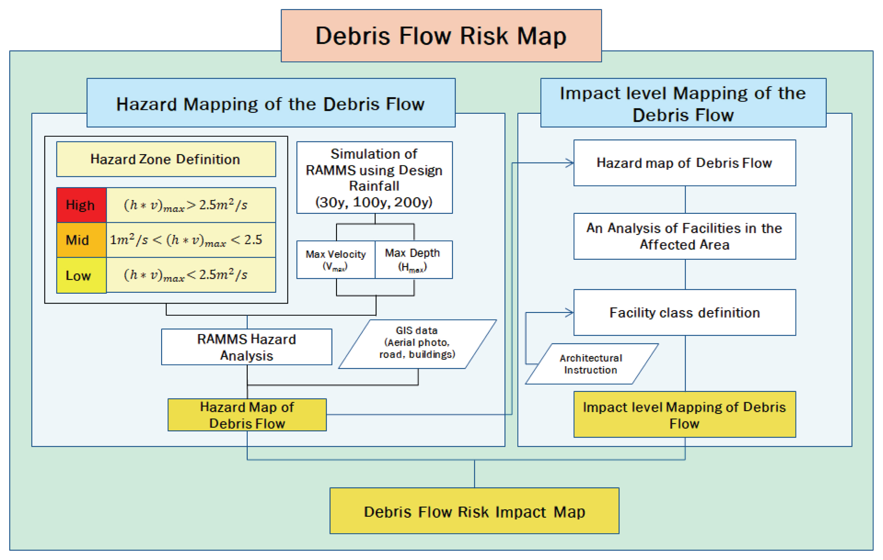
3.3 ņ£äĒŚśļÅä ļ¦żĒŖĖļ”ŁņŖż(Risk impact matrix)
ļ│Ė ļģ╝ļ¼ĖņŚÉņä£ ĒåĀņäØļźś ņ£äĒŚśņśüĒ¢źņ¦ĆļÅäļŖö ĒåĀņäØļźśĻ░Ć Ļ░ĆĒĢĀ ņ£äĒĢ┤ņä▒Ļ│╝ ņŗ£ņäżļ¼╝ņŚÉ ļīĆĒĢ£ ņśüĒ¢źņØä Ļ│▒ņ£╝ļĪ£ ļéśĒāĆļéĖļŗż(Eq. (3)). ņ£äĒŚśļÅä ļ¦żĒŖĖļ”ŁņŖż(Risk matrix)ļŖö ņ£äĒŚśņØä ņĀĢļ¤ēĒÖöĒĢśļŖö ĻĖ░ļ▓Ģņ£╝ļĪ£ ņ£äĒŚśĻ┤Ćļ”¼(Risk management)ņØś ņżæņÜöĒĢ£ ļČĆļČäņØĖ ņ£äĒŚśĒÅēĻ░Ć(Risk assessment)ņØś ņ£äĒŚśļČäņäØļ░®ļ▓Ģņ£╝ļĪ£ ņ£äĒŚśņŚÉ ļīĆĒĢ┤ņä£ ņĀĢĒÖĢĒ׳ ņśłņāüĒĢśĻ│Ā ļČäņäØĒĢśņŚ¼ ņ£äĒŚśņØä ņżäņØ┤ļŖö ļ░®ļ▓ĢņØ┤ļŗż(Shin et al., 2013). ņ£äĒĢ┤ņä▒(Hazard)Ļ│╝ ĻĘĖ ņ£äĒŚśņØ┤ ļ»Ėņ╣Ā ņłś ņ׳ļŖö ņŗ£ņäżļ¼╝ņØśņŚÉ ļīĆĒĢ£ ņśüĒ¢ź(Impact)ņØĆ ņØ╝ļ░śņĀüņ£╝ļĪ£ ņĀĢĒÖĢĒĢśĻ▓ī Ļ░Æņ£╝ļĪ£ Ēæ£ĒśäĒĢĀ ņłś ņŚåĻĖ░ņŚÉ ņ£äĒŚś ļ¦żĒŖĖļ”ŁņŖżļŖö ņ£äĒŚśņØś ĒÖĢļźĀĻ│╝ ņżæņÜöļÅäļź╝ ļŗ©Ļ│ä(Level)ļĪ£ ļéśļłäņ¢┤ņä£ ņĄ£ņóģ ņ£äĒŚśņØä ĒīÉļŗ©ĒĢ£ļŗż(Table 1).
3.4 ĒåĀņäØļźś ņ£äĒĢ┤ņä▒ņ¦ĆļÅä(Debris flow hazard map)
ĒåĀņäØļźś ņ£äĒĢ┤ņä▒ņ¦ĆļÅäļŖö ĒåĀņäØļźś Ēö╝ĒĢ┤ļź╝ ĻĘ╣ļīĆĒÖö ņŗ£ĒéżļŖö ņØĖņ×ÉņØĖ ĒåĀņäØņ£ĀļÅÖņŗ¼(H)Ļ│╝ ĒåĀņäØņ£ĀņåŹ(V)ņØä ņØ┤ņÜ®ĒĢśņŚ¼ ņ£äĒŚśļō▒ĻĖēņØä ļČäļźśĒĢśņśĆņ£╝ļ®░, ĒåĀņäØņ£ĀļÅÖņŗ¼Ļ│╝ ĒåĀņäØņ£ĀņåŹņØś Ļ│▒ņØ┤ 2.5 m2/s ņØ┤ņāüņØ╝ ļĢī ņ£äĒŚśļō▒ĻĖē ļåÆņØī(High), 1 m2/s ņØ┤ņāüņØ┤Ļ▒░ļéś 2.5 m2/s ņØ┤ĒĢśņØ╝ ļĢī ņżæĻ░ä(Middle), 1 m2/s ņØ┤ĒĢśņØ╝ ļĢī ļé«ņØī(Low)ņ£╝ļĪ£ ņé░ņĀĢĒĢśņŚ¼ ņ×æņä▒ĒĢśņśĆļŗż. Eq. (4)ļŖö ĒåĀņäØļźś ņ£äĒĢ┤ņä▒ņ¦ĆļÅä ņ×æņä▒ņŚÉ ļīĆĒĢ£ ņé░ņĀĢņŗØņØä ļéśĒāĆļāłņ£╝ļ®░, Table 2ļŖö ņ£äĒĢ┤ņä▒ņ¦ĆļÅä ņé░ņĀĢ ĻĖ░ņżĆņØä ļéśĒāĆļāłļŗż.
3.5 ņśüĒ¢źņżæņÜöļÅäņ¦ĆļÅä(Impact level map)
ĒåĀņäØļźś ņśüĒ¢źņżæņÜöļÅäņ¦ĆļÅäļŖö ĻĄŁĒåĀĻĄÉĒåĄļČĆ ņÜ®ļÅäļ│ä Ļ▒┤ņČĢļ¼╝ņØś ņóģļźś(MOLIT, 2017)ļź╝ ņØ┤ņÜ®ĒĢśņŚ¼ 3ļŗ©Ļ│äļĪ£ ļČäļźśĒĢśņśĆļŗż. ņé¼ļ×īņØ┤ ņŻ╝Ļ▒░ĒĢśļŖö ļŗ©ļÅģņŻ╝ĒāØ, Ļ│ĄļÅÖņŻ╝ĒāØ, ņĢäĒīīĒŖĖ, ņŚ┤ļ”ĮņŻ╝ĒāØ, ļŗżņäĖļīĆņŻ╝ĒāØ, ĻĖ░ņłÖņé¼ ļō▒ņØä ņ£äĒŚśļō▒ĻĖē ļåÆņØīņ£╝ļĪ£ ļČäļźśĒĢśņśĆņ£╝ļ®░, ņé¼ļ×īņØś ņāØĒÖ£ ĒÄĖņØśļź╝ ļÅäņÜ░ļŖö ņĀ£1ņóģ ĻĘ╝ļ”░ņŗ£ņäż(Ļ░ĆĻ│ä, ļ│æņøÉ, ĻĄÉĒÜī, ņé¼ļ¼┤ņåī ļō▒), ņĀ£2ņóģ ĻĘ╝ļ”░ņŗ£ņäż(ņśüĒÖöĻ┤Ć, ĒĢÖņøÉ, ļÅÖļ¼╝ļ│æņøÉ ļō▒)ņØ┤ļéś ņØ╝ļ░śļÅäļĪ£ļź╝ ņżæĻ░äļō▒ĻĖēņ£╝ļĪ£ ļČäļźśĒĢśņśĆĻ│Ā, ĻĘĖ ļ░¢ņØś ĒÅēņ¦Ć, ļģ╝, ļ░ŁņØä ļé«ņØī ļō▒ĻĖēņ£╝ļĪ£ ļéśĒāĆļāłļŗż. Table 3ņØĆ ņŗ£ņäżļ¼╝ņØś ņżæņÜöļÅäļ│ä ļČäļźśĻĖ░ņżĆņØä ļéśĒāĆļāłļŗż.
4. ņŚ░ĻĄ¼Ļ▓░Ļ│╝
ļ│Ė ļģ╝ļ¼ĖņŚÉņä£ļŖö ņä£ņÜĖņŗ£ ņÜ░ļ®┤ņé░ ņØ╝ļīĆņÖĆ ņČśņ▓£ņŗ£ ļ¦łņĀüņé░ ņØ╝ļīĆļź╝ ļīĆņāüņ£╝ļĪ£ ĒåĀņäØļźś ņ£äĒŚśņśüĒ¢źņ¦ĆļÅäļź╝ ņ×æņä▒ĒĢśĻĖ░ ņ£äĒĢśņŚ¼ ĒåĀņäØļźśļź╝ ņ£Āļ░£ĒĢśļŖö ļ╣łļÅäļ│ä(30ļģä, 100ļģä, 200ļģä) Ļ░ĢņÜ░ļČäņäØņØä ņŗżņŗ£ĒĢśņŚ¼ ĒåĀņäØļźś ņłśņ╣śļ¬©ĒśĢ RAMMSņØś ņ×ģļĀźņ×ÉļŻīņØĖ ņ▓©ļæÉĒÖŹņłśļ¤ē ļ░Å ņ£ĀņČ£ņ┤Øļ¤ēņØä ņé░ņĀĢĒĢśņśĆņ£╝ļ®░, ņé░ņĀĢļÉ£ ļ╣łļÅäļ│ä(30ļģä, 100ļģä, 200ļģä) ņ▓©ļæÉĒÖŹņłśļ¤ē ļ░Å ņ£ĀņČ£ņ┤Øļ¤ēņØä RAMMSļ¬©ĒśĢņŚÉ ņĀüņÜ®ĒĢśņŚ¼ ĒåĀņäØņ£ĀļÅÖņŗ¼ ļ░Å ĒåĀņäØņ£ĀņåŹņØä ņé░ņĀĢĒĢśņśĆļŗż. ļČäĒżĒśĢ Ļ░ĢņÜ░-ņ£ĀņČ£ļ¬©ĒśĢ S-RATņØä ņØ┤ņÜ®ĒĢ£ Ļ░ĢņÜ░ļČäņäØ Ļ▓░Ļ│╝ņÖĆ ĒåĀņäØļźś ņłśņ╣śĒĢ┤ņäØļ¬©ĒśĢ RAMMSļź╝ ņØ┤ņÜ®ĒĢ£ Ļ▓░Ļ│╝ ļ░Å NSI ņĀĢļ¤ēņ¦Ćņłśļź╝ ņØ┤ņÜ®ĒĢ£ ļ¦żĻ░£ļ│Ćņłś ņĄ£ņĀüĒÖöņŚÉ ļīĆĒĢ£ Ļ▓░Ļ│╝ļŖö Nam et al. (2016)ņŚÉņä£ ņĀ£ņŗ£ĒĢ£ ņĄ£ņĀüļ¦żĻ░£ļ│Ćņłśļź╝ ņé¼ņÜ®ĒĢśņśĆļŗż.
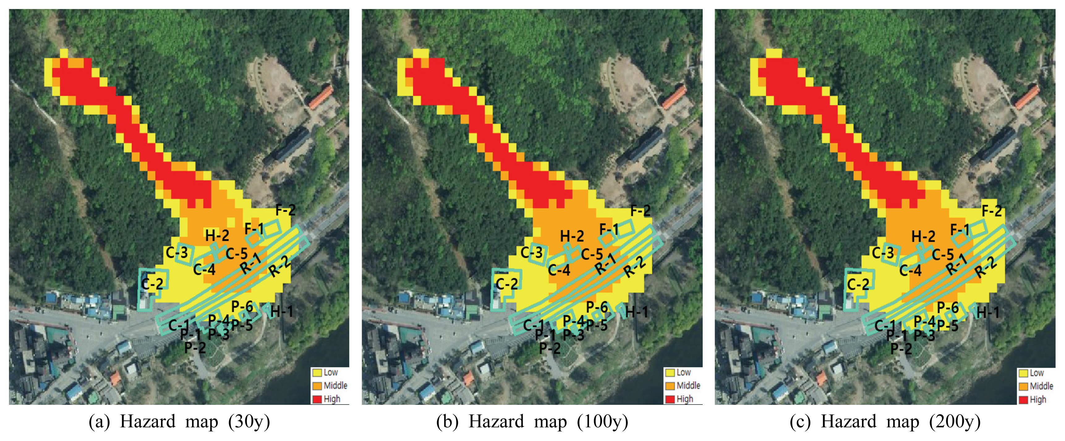
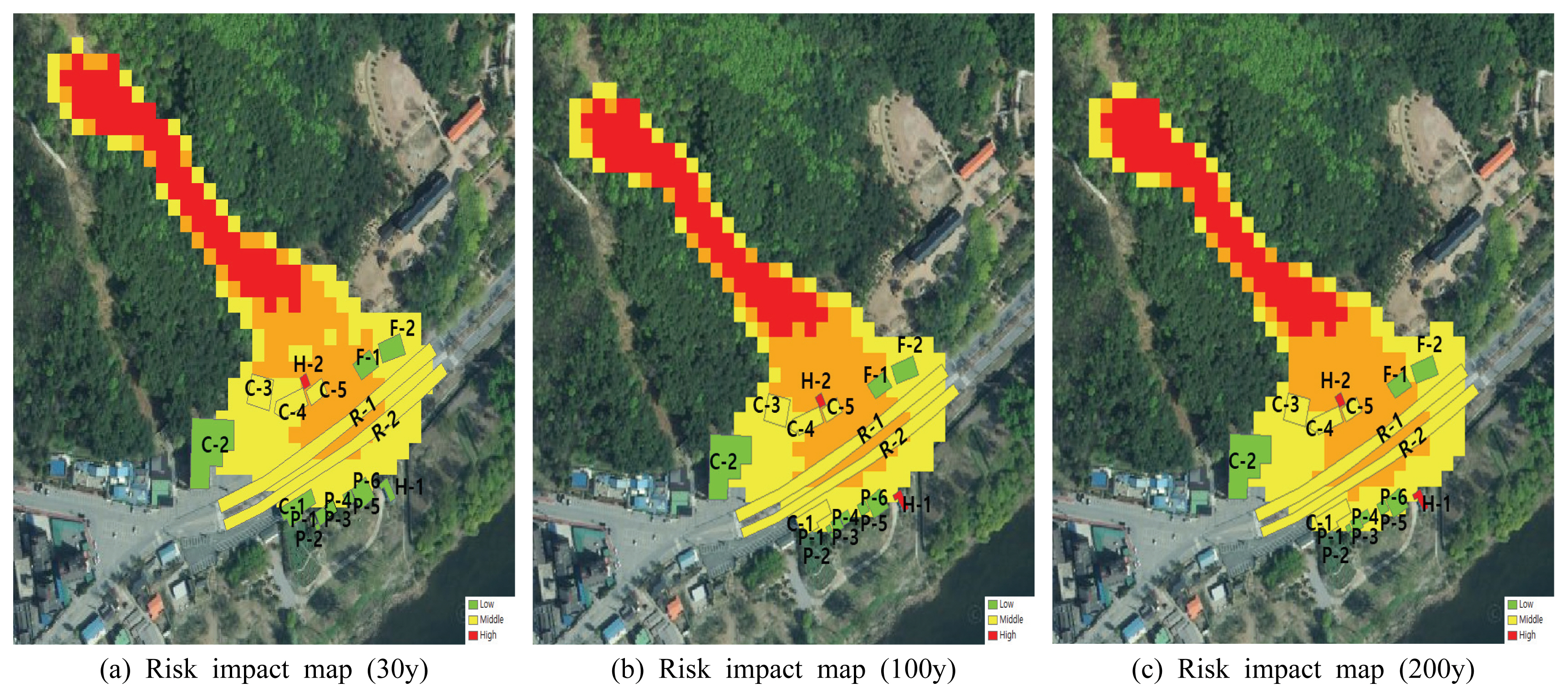
ņä£ņÜĖņŗ£ ņÜ░ļ®┤ņé░Ļ│╝ ņČśņ▓£ņŗ£ ļ¦łņĀüņé░ņØś ĒåĀņäØļźś ņ£äĒŚśņśüĒ¢źņ¦ĆļÅä ņ×æņä▒ Ļ▓░Ļ│╝ ņä£ņÜĖņŗ£ ņÜ░ļ®┤ņé░ņØś Ļ▓ĮņÜ░ ņĢäĒīīĒŖĖ A-1, A-2, A-5, A-6ņØĆ ņ£äĒĢ┤ņä▒ņ¦ĆļÅäņŚÉņä£ļŖö ņ£äĒŚśļō▒ĻĖēņØ┤ ļé«ņØīņØ┤ļéś, ņśüĒ¢źņżæņÜöļÅäņ¦ĆļÅäļĪ£ ļ│╝ ļĢī ņ£äĒŚśļō▒ĻĖē ļåÆņØīņ£╝ļĪ£ ņé░ņĀĢļÉśņŚłņ£╝ļ®░, ņ£äĒŚśņśüĒ¢źņ¦ĆļÅäņŚÉņä£ļŖö ņ£äĒŚśļō▒ĻĖē ļåÆņØīņ£╝ļĪ£ ņé░ņĀĢļÉśņŚłļŗż. C-1ņØĆ ņ£äĒĢ┤ņä▒ņ¦ĆļÅäļéś ņżæņÜöļÅäņŚÉņä£ļÅä ņ£äĒŚśļō▒ĻĖē ņżæĻ░äņ£╝ļĪ£ ņé░ņĀĢļÉśņŚłņ£╝ļ®░, ņ£äĒŚśņśüĒ¢źņ¦ĆļÅäņŚÉņä£ļÅä ņżæĻ░ä ļō▒ĻĖēņ£╝ļĪ£ ņé░ņĀĢļÉśņŚłļŗż. ņŗżņĀ£ļĪ£ C-1ņØĆ ĒåĀņäØļźś Ēö╝ĒĢ┤ļĪ£ ņØĖĒĢ┤ ņÖäĒīīļÉśņ¢┤ ņ×¼Ļ▒┤ņČĢļÉśņŚłļŗż. A-3, A-4ņØś Ļ▓ĮņÜ░ 30ļģä ļ╣łļÅäņØ╝ ļĢīņŚÉļŖö Ēö╝ĒĢ┤ļź╝ ļ░øņ¦Ć ņĢŖņ£╝ļéś 100ļģä, 200ļģä ļ╣łļÅäņØ╝ ļĢī Ēö╝ĒĢ┤Ļ░Ć ļ░£ņāØĒĢśņśĆņ£╝ļ®░, ņ£äĒĢ┤ņä▒ņ¦ĆļÅäņŚÉņä£ļŖö ņ£äĒŚśļō▒ĻĖēņØ┤ ļé«ņØīņ£╝ļĪ£ ņé░ņĀĢļÉśņŚłņ£╝ļéś ņśüĒ¢źņżæņÜöļÅäņ¦ĆļÅäļĪ£ ļ│╝ ļĢīļŖö ļåÆņØī ļō▒ĻĖēņ£╝ļĪ£ ņé░ņĀĢļÉśņŚłĻ│Ā, ņ£äĒŚśņśüĒ¢źņ¦ĆļÅäņŚÉņä£ļÅä ņ£äĒŚśļō▒ĻĖē ļåÆņØīņ£╝ļĪ£ ņé░ņĀĢļÉśņŚłļŗż. R-1ņØĆ ņ£äĒĢ┤ņä▒ņ¦ĆļÅäņŚÉņä£ ļåÆņØī ļō▒ĻĖēņ£╝ļĪ£ ļéśĒāĆļé¼Ļ│Ā, ņśüĒ¢źņżæņÜöļÅäņ¦ĆļÅäņŚÉņä£ļŖö ņżæĻ░äņ£╝ļĪ£ ņé░ņĀĢļÉśņŚłņ£╝ļéś ņ£äĒŚśņśüĒ¢źņ¦ĆļÅäļĪ£ ņé░ņĀĢĒĢśņśĆņØä ļĢī ļåÆņØī ņ£äĒŚśļō▒ĻĖēņ£╝ļĪ£ ļéśĒāĆļé¼ļŗż.
ņČśņ▓£ņŗ£ ļ¦łņĀüņé░ņØĆ P-1, P-2, P-3, H-1ņØĆ 30ļģä ļ╣łļÅäņØ╝ Ļ▓ĮņÜ░ Ēö╝ĒĢ┤ļź╝ ļ░øņ¦Ć ņĢŖņ£╝ļ®░ 100ļģä, 200ļģä ļ╣łļÅäļČĆĒä░ Ēö╝ĒĢ┤Ļ░Ć ļ░£ņāØĒĢśļ®░, ņ£äĒĢ┤ņä▒ņ¦ĆļÅäņŚÉņä£ņØś ņ£äĒŚśļō▒ĻĖēņØĆ ļé«ņØī, ņśüĒ¢źņżæņÜöļÅäņ¦ĆļÅäļĪ£ ļ│┤ņĢśņØä ļĢī ņżæĻ░äļō▒ĻĖēņ£╝ļĪ£ ņé░ņĀĢļÉśņŚłņ£╝ļ®░, ņ£äĒŚśņśüĒ¢źņ¦ĆļÅäņŚÉņä£ļŖö ņ£äĒŚśļō▒ĻĖē ļé«ņØīņ£╝ļĪ£ ņé░ņĀĢļÉśņŚłļŗż. P-4, P-5, P-6 ļśÉĒĢ£ ņ£äĒĢ┤ņä▒ņ¦ĆļÅäņŚÉņä£ ļé«ņØī ļō▒ĻĖēņ£╝ļĪ£ ņé░ņĀĢļÉśņŚłĻ│Ā, ņśüĒ¢źņżæņÜöļÅäņ¦ĆļÅä ļśÉĒĢ£ ņżæĻ░äļō▒ĻĖēņ£╝ļĪ£ ņé░ņĀĢļÉśņŚłļŗż. R-1, R-2ļŖö ņ£äĒĢ┤ņä▒ņ¦ĆļÅäņŚÉņä£ ņżæĻ░äļō▒ĻĖēņ£╝ļĪ£ ņé░ņĀĢļÉśņŚłĻ│Ā, ņśüĒ¢źņżæņÜöļÅäņ¦ĆļÅä ļśÉĒĢ£ ņżæĻ░äļō▒ĻĖēņ£╝ļĪ£ ņé░ņĀĢļÉśņ¢┤ ņ£äĒŚśņśüĒ¢źņ¦ĆļÅäņŚÉļŖö ņżæĻ░äļō▒ĻĖēņ£╝ļĪ£ ņé░ņĀĢļÉśņŚłļŗż. F-1, F-2ļŖö ņ£äĒĢ┤ņä▒ņ¦ĆļÅäļĪ£ ļ│╝ ļĢÉ ņ£äĒŚśļō▒ĻĖēņØ┤ ņżæĻ░äļō▒ĻĖēņØ┤ļéś, ņśüĒ¢źņżæņÜöļÅäņ¦ĆļÅäļĪ£ ļ│╝ ļĢÉ ļé«ņØī, ņ£äĒŚśņśüĒ¢źņ¦ĆļÅä ļśÉĒĢ£ ļé«ņØīņ£╝ļĪ£ ņé░ņĀĢļÉśņŚłļŗż. H-1ņØĆ 100ļģä ļ╣łļÅä ļ░Å 200ļģä ļ╣łļÅäņØ╝ ņØ╝ ļĢī ņ£äĒŚśņśüĒ¢źņ¦ĆļÅäņŚÉņä£ļŖö ļåÆņØī ļō▒ĻĖēņ£╝ļĪ£ ņé░ņĀĢļÉśņŚłņ£╝ļ®░, H-2ņØś Ļ▓ĮņÜ░ ņ£äĒĢ┤ņä▒ņ¦ĆļÅäņŚÉņä£ļŖö ņżæĻ░äļō▒ĻĖēņØ┤ļéś, ņśüĒ¢źņżæņÜöļÅäņ¦ĆļÅäņŚÉņä£ļŖö ļåÆņØī ļō▒ĻĖēņ£╝ļĪ£ ņ£äĒŚśņśüĒ¢źņ¦ĆļÅäņŚÉņä£ ļåÆņØī ļō▒ĻĖēņ£╝ļĪ£ ļéśĒāĆļé¼ļŗż. ņŗżņĀ£ļĪ£ H-2ļŖö ĒåĀņäØļźśļĪ£ ņØĖĒĢ┤ ļ¦ÄņØĆ Ēö╝ĒĢ┤Ļ░Ć ļ░£ņāØĒĢ£ Ļ││ņØ┤ļŗż. C-1ņØĆ ņżæĻ░äļō▒ĻĖē, C-2ļŖö 30ļģä, 100ļģä ļ╣łļÅäņØ╝ ļĢī ļé«ņØī ļō▒ĻĖēņ£╝ļĪ£ ļ│┤ņØ┤ļéś 200ļģä ļ╣łļÅäņØ╝ ļĢī ņżæĻ░äļō▒ĻĖēņ£╝ļĪ£ ņé░ņĀĢļÉśņŚłļŗż. C-3, C-4, C-5ļŖö ņ£äĒĢ┤ņä▒ņ¦ĆļÅä ļ░Å ņśüĒ¢źņżæņÜöļÅäņ¦ĆļÅäņŚÉņä£ ņżæĻ░äļō▒ĻĖēņ£╝ļĪ£ ļéśĒāĆļé¼Ļ│Ā, ņ£äĒŚśņśüĒ¢źņ¦ĆļÅäņŚÉņä£ ļśÉĒĢ£ ņżæĻ░äļō▒ĻĖēņ£╝ļĪ£ ņé░ņĀĢļÉśņŚłļŗż(Tables 4, 5). Figs. 4, 5ļŖö ņä£ņÜĖņŗ£ ņÜ░ļ®┤ņé░Ļ│╝ ņČśņ▓£ņŗ£ ļ¦łņĀüņé░ņØś ĒåĀņäØļźś ņ£äĒĢ┤ņä▒ņ¦ĆļÅäļź╝ ļéśĒāĆļāłĻ│Ā, Fig. 6ņØĆ ņŗ£ņäżļ¼╝ ņśüĒ¢źņżæņÜöļÅäņ¦ĆļÅäļź╝ ļéśĒāĆļéĖ Ļ▓āņØ┤ļ®░ Figs. 7, 8ņØĆ ņ£äĒŚśņśüĒ¢źņ¦ĆļÅäļź╝ ļéśĒāĆļéĖ Ļ▓āņØ┤ļŗż.
5. Ļ▓░ ļĪĀ
ļ│Ė ļģ╝ļ¼ĖņŚÉņä£ļŖö 2011ļģä ĒåĀņäØļźś Ēö╝ĒĢ┤ņ¦ĆņŚŁņØĖ ņä£ņÜĖņŗ£ ņÜ░ļ®┤ņé░ ņØ╝ļīĆņÖĆ ņČśņ▓£ņŗ£ ļ¦łņĀüņé░ ņØ╝ļīĆļź╝ ļīĆņāüņ£╝ļĪ£ ĒåĀņäØļźś ņ£äĒŚśņśüĒ¢źņ¦ĆļÅäļź╝ ņ×æņä▒ĒĢśĻĖ░ ņ£äĒĢ┤ ļ╣łļÅäļ│ä ĒÖĢļźĀĻ░ĢņÜ░ļ¤ē(30ļģä, 100ļģä, 200ļģä)ņØä ņØ┤ņÜ®ĒĢśņŚ¼ ļČäĒżĒśĢ Ļ░ĢņÜ░-ņ£ĀņČ£ļ¬©ĒśĢ S-RATņŚÉ ņĀüņÜ®ĒĢśņŚ¼ ĒåĀņäØļźśļź╝ ņ£Āļ░£ĒĢśļŖö ņØĖņ×ÉņØĖ ņ▓©ļæÉĒÖŹņłśļ¤ēĻ│╝ ņ£ĀņČ£ņ┤Øļ¤ēņØä ņé░ņĀĢĒĢśņśĆņ£╝ļ®░, ņé░ņĀĢļÉ£ ņ▓©ļæÉĒÖŹņłśļ¤ēĻ│╝ ņ£ĀņČ£ņ┤Øļ¤ēņØä ņØ┤ņÜ®ĒĢśņŚ¼ ĒåĀņäØļźś ņłśņ╣śĒĢ┤ņäØ ļ¬©ĒśĢņØĖ RAMMSņŚÉ ņĀüņÜ®ĒĢśņŚ¼ ļ╣łļÅäļ│ä ĒåĀņäØņ£ĀļÅÖņŗ¼(H)Ļ│╝ ĒåĀņäØņ£ĀņåŹ(V)ņØä ņé░ņĀĢĒĢśņśĆļŗż. ĒåĀņäØļźśņØś Ēö╝ĒĢ┤ļź╝ ĻĘ╣ļīĆĒÖöņŗ£ĒéżļŖö ņØĖņ×ÉņØĖ ĒåĀņäØņ£ĀļÅÖņŗ¼Ļ│╝ ĒåĀņäØņ£ĀņåŹņØä ņØ┤ņÜ®ĒĢśņŚ¼ ļ╣łļÅäļ│ä ĒåĀņäØļźś ņ£äĒĢ┤ņä▒ņ¦ĆļÅäļź╝ ņ×æņä▒ĒĢśņŚ¼ ļåÆņØī, ņżæĻ░ä, ļé«ņØī 3ļŗ©Ļ│äļĪ£ ļČäļźśĒĢśņśĆļŗż. ļśÉĒĢ£ ĒåĀņäØļźśļĪ£ ņØĖĒĢ┤ ĒĢśļČĆņŚÉ Ēö╝ĒĢ┤ļź╝ ļ░øļŖö ņŗ£ņäżļ¼╝ņØä ĻĄŁĒåĀĻĄÉĒåĄļČĆ ņÜ®ļÅäļ│ä Ļ▒┤ņČĢļ¼╝ņØś ņÜ®ļÅä(MOLIT, 2017)ņŚÉ ņØśĻ▒░ĒĢśņŚ¼ ļåÆņØī, ņżæĻ░ä, ļé«ņØī 3ļŗ©Ļ│äļĪ£ ļČäļźśĒĢśņśĆņ£╝ļ®░, ņĄ£ņóģņĀüņ£╝ļĪ£ ņ£äĒĢ┤ņä▒ņ¦ĆļÅäņÖĆ ņśüĒ¢źņżæņÜöļÅäņ¦ĆļÅäļź╝ ņ£äĒŚśļÅä ļ¦żĒŖĖļ”ŁņŖżņŚÉ ņĀüņÜ®ĒĢśņŚ¼ ĒåĀņäØļźś ņ£äĒŚśņśüĒ¢źņ¦ĆļÅäļź╝ ņ×æņä▒ĒĢśņśĆļŗż. ņä£ņÜĖņŗ£ ņÜ░ļ®┤ņé░ ļ░Å ņČśņ▓£ņŗ£ ļ¦łņĀüņé░ņØś ĒåĀņäØļźś ņ£äĒŚśņśüĒ¢źņ¦ĆļÅä ņ×æņä▒ Ļ▓░Ļ│╝ ņä£ņÜĖņŗ£ ņÜ░ļ®┤ņé░ņØś Ļ▓ĮņÜ░ 30ļģäņØś ļ╣łļÅäņŚÉņä£ A-1, A-2, A-3, A-4, A-5, A-6, R-1 ļ¬©ļæÉ ļÅÖņØ╝ĒĢśĻ▓ī ļåÆņØī ļō▒ĻĖēņ£╝ļĪ£ ļéśĒāĆļé¼ņ£╝ļ®░, C-1ņØĆ ņżæĻ░ä ļō▒ĻĖēņ£╝ļĪ£ ļéśĒāĆļé¼ļŗż. 100ļģä ļ╣łļÅä ļ░Å 200ļģä ļ╣łļÅäļŖö ļ¬©ļæÉ ļÅÖņØ╝ĒĢśĻ▓ī ļåÆņØī ļō▒ĻĖēņ£╝ļĪ£ ļéśĒāĆļé¼ļŗż. ļśÉĒĢ£ ņČśņ▓£ņŗ£ņØś Ļ▓ĮņÜ░ 30ļģäņØś ļ╣łļÅäņŚÉņä£ļŖö F-1, F-2, C-1, C-2, P-1, P-2, P-3, P-4, P-5, P-6ņØ┤ ļé«ņØī ļō▒ĻĖē, C-3, C-4, C-5, R-1, R-2Ļ░Ć ņżæĻ░ä ļō▒ĻĖē, H-2Ļ░Ć ļåÆņØī ļō▒ĻĖēņ£╝ļĪ£ ļéśĒāĆļé¼ņ£╝ļ®░, 100ļģä ļ╣łļÅä ļ░Å 200ļģä ļ╣łļÅäņŚÉņä£ļŖö Ēö╝ĒĢ┤ ĻĘ£ļ¬©Ļ░Ć ņ╗żņ¦Ćļ®┤ņä£ H-1ņØ┤ ļåÆņØī ļō▒ĻĖēņ£╝ļĪ£ ļéśĒāĆļé¼ļŗż. ņØ┤ļ¤¼ĒĢ£ Ļ▓░Ļ│╝ļź╝ ļ│╝ ļĢī ĒåĀņäØļźśņØś Ēö╝ĒĢ┤ ĻĘ£ļ¬©ļÅä ņżæņÜöĒĢ£ ņØĖņ×ÉņØ┤ļéś ĒĢśļČĆņØś ĻĄ¼ņĪ░ļ¼╝ņØś ņÜ®ļÅä(ņŻ╝Ļ▒░ņ¦Ć, ņŗØļŗ╣, ļéśņ¦Ć ļō▒) ļ░Å ĻĄ¼ņĪ░ļ¼╝ņØś ņ×¼ļŻī(ņĮśĒü¼ļ”¼ĒŖĖ, ņĪ░ņĀüņĪ░, ļ¬®ņĪ░ ļō▒)ņŚÉ ļö░ļØ╝ Ēö╝ĒĢ┤Ļ░Ć Ēü¼Ļ▓ī ļŗ¼ļØ╝ņ¦äļŗż. ļö░ļØ╝ņä£ ļ│Ė ļģ╝ļ¼ĖņŚÉņä£ ņ×æņä▒ĒĢ£ ĒåĀņäØļźś ņ£äĒŚśņśüĒ¢źņ¦ĆļÅäļź╝ ņĀäĻĄŁņĀüņ£╝ļĪ£ ņ×æņä▒ĒĢśņŚ¼ ļÅäņŗ£Ļ│äĒÜŹ ļ░Å ļ░®ņ×¼Ļ│äĒÜŹņŚÉ ņØ┤ņÜ®ĒĢ£ļŗżļ®┤ ņŗĀĻĘ£ ĻĄ¼ņĪ░ļ¼╝ņØś ņ×¼ļŻī Ļ▓░ņĀĢņØ┤ Ļ░ĆļŖźĒĢĀ Ļ▓āņØ┤ļØ╝ ĒīÉļŗ©ļÉ£ļŗż. Ē¢źĒøä ņŚ░ĻĄ¼Ļ│äĒÜŹņ£╝ļĪ£ļŖö ĒĢśļČĆņØś ĻĄ¼ņĪ░ļ¼╝ņØ┤ ļ░øļŖö ņÖĖļĀź(Pressure)Ļ│╝ ĻĄ¼ņĪ░ļ¼╝ņØś ņ×¼ļŻīļ│äņŚÉ ļö░ļØ╝ ņĀĆĒĢŁĒĢśļŖö ņĀĆĒĢŁļĀź(Resistance)ņØä Ļ│ĀļĀżĒĢśņŚ¼ ņ£äĒŚśņśüĒ¢źņ¦ĆļÅäļź╝ Ļ░£ņäĀĒĢĀ Ļ│äĒÜŹņØ┤ļŗż.