Estimation of Soil Erosion Using RUSLE Model and GIS Techniques forConservation Planning from Kulekhani Reservoir Catchment, Nepal
Article information
Abstract
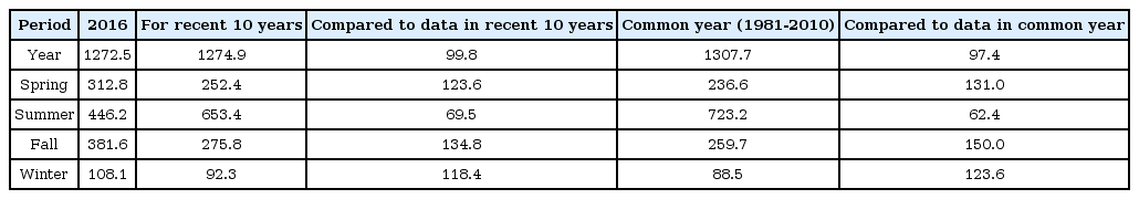
This study intended to spatially estimate the soil erosion rate of Kulekhani reservoir catchment area, Nepal applying Revised UniversalSoil Loss Equation (RUSLE), adopting remote sensing data and geographic information system (GIS) techniques. Average soilerosion rate of watershed was found to be 195.11Mg ha-1 year-1 which is quite high as compared to threshold rate of erosion 15Mg ha-1 year-1 applicable for Himalayan region. It is concluded that soil erosion rate of comparatively 41% area was tolerable but has no distinctzone and approximately 58% area of catchment was on the verge of high to very severe intensity classes. Higher severity of soilerosion was scattered all over the watershed hence conservation measures should be implemented over whole catchment area. Theresearch demonstrates that the use of remote sensing data and GIS has an abundant advantage in predicting soil erosion rate for thesustainable land use and ecological management planning of Himalayan region of Nepal.
Trans Abstract
본 연구에서는 개정범용토양유실공식을 적용하고 위성자료를 활용한 GIS기법을 통해 네팔의 쿨리카니 저수지(Kulekhani reservoir) 유역의 공간적인 토양침식률을 예측하였다. 쿨라카니저수지 유역의 평균토양침식률은 195.11Mg/ha·yr로 산정되었으며 이 수치는 히말라야 지역의 토양침식률 역치인 15Mg/ha·yr 과 비교하여 상당히 높은 것으로 분석되었다. 산정된 토양침식률 분포는 침식정도에 따라 slight, moderate, high, very high, severe, very severe 6가지 등급으로 구분하였다. 분석결과, 유역전체 면적의 41%는 slight erosion, 1%는 moderate erosion, 58%는 high erosion과 severe erosion 등급으로 나타났다. 유역 전체에서 토양침식률이 높게 나타나 전 유역에 대한 토양침식의 보존을 위한 대책이 수립되어야 할 것으로 판단된다. 또한, GIS를 통한 위성자료의 활용은 네팔 히말라야 지역의 지속가능한 토지이용과 생태관리계획을 위한 토양침식률 추정에 매우 유용한 것으로 판단된다.
1. Introduction
Sustainable use of the hydraulic infrastructures depends on our understanding of the erosion and sedimentation processes and how to pertain them in designing hydraulic structures (Yang, Randle & Daraio, 2006). Sedimentation is a major issue in reservoirs which reduces the life of by lowering the capacity of water storage (McCully, 1997). Reservoirs are potentially the most long-lived of any operational structures. Several multipurpose reservoirs are built across the river to maintain water for water supply, irrigation, hydroelectricity and flood controls (Morris and Fan, 1998).
A healthy reservoir requires a healthy river and only a healthy watershed can provide healthy river. Here, healthy refers to the condition of reservoir or river that the greatest extent possible unpolluted, supportive and able to flood according to natural pattern. Maintaining watersheds with healthy soils, forests and wetlands minimizes cuts down erosion and so the amount of sediments washed from surface (McCully, 1997). Most area of mountain watersheds are posed of steep slopes which are prone to accelerated soil erosion succeeding disturbances of natural or artificial processes (Bonorino et al., 2003). Assessment of soil erosion from watershed and sedimentation monitoring is essential to provide guidance in land use management and conservation measures planning under natural condition especially, for hydropower generation. However, estimation of soil loss in a mountainous region is challenging due to its intricate topography.
Widely used potential soil erosion assessing tool is Universal Soil Loss Equation (USLE) and its revised version (RUSLE), because of its simplicity (Fox & Bryan, 2000). Initially, USLE/RUSLE was developed for assessing soil erosion on specific slope in specific fields such as croplands (Renard et al., 1991). However, use of GIS (Geographic Information System) environments and remote sensing has greatly eased its applicability to larger areas and steep landscape such as mountain (Bonorino et al., 2003).
In this study, Revised RUSLE equation was applied along with GIS environments to estimate soil erosion from a catchment area belonging to Kulekhani reservoir in the middle mountain range of Nepal. This reservoir is running two hydroelectricity power stations of capacity 92 MW and one project of capacity 14 MW is under construction. Original gross capacity of the reservoir was 85.3 million m3, of which 73.3 million m3 was for live and 11.2 million m3 was for dead volume. During early 1980’s, this reservoir was designed for a life-span of 50 years and was expected to last for 100 years (Sthapit, 1996). A siltation survey carried out by the Department of Soil Conservation in 1994 in the Kulekhani reservoir revealed that the sediment deposited during a year of 1993 had reduced the gross capacity of reservoir by 10.19 million m3 of its original capacity (Pradhan et al., 2012). Present study aims to generate spatial erosion map with RUSLE and GIS technique and to evaluate the applicability of RUSLE model for evaluation of long term soil erosion status and distribution in mountainous terrain of Himalayan region in Nepal. This is a case study for the application of RUSLE in GIS framework in the mountainous region with steep slopes.
2. Materials and Method
2.1 Study Watershed
Study watershed is located southwest of capital city Kathmandu (80 km road distance) in the Mahabharat range (middle Himalayan zone) of central Nepal. The catchment area lies between the latitudes 27°41’ and 27°35’04’’N, and longitudes 85°00’32’’ and 85°12’12’’ as presented in Fig. 1 along with the contour map of contour interval 50m. Kulekhani watershed occupies 124.75 km2 of areal area. The geology of area is fragile which experiences intense rainfall events throughout monsoon season. Almost 80% of the total rainfall occurs during Indian Monsoon Season (ISM) that is between June to September each year (Pradhan et al., 2012; Sthapit, 1996). The catchment area has been extensively used in response to meeting people’s daily basic needs for food, fodder, wood and firewood fiber and shelter. As a result, the erosion processes transport an enormous amount of sediment to the reservoir from watershed which is affecting the reservoir capacity and expected life-span of reservoir.
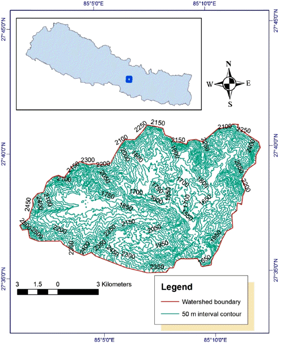
Location map and contour map of watershed with contour interval 50 m
Elevation of the Kulekhani reservoir outlet is about 1484 meters above sea level and the south-western ridge of Palung Khola marks the summit at 2577 meters above sea level. Tasar, Bisingkhel and Chitlang Kholas are the major tributaries of the reservoir having average slopes range of 1.2% to 21.3%. (Sthapit, 1996).
Only 0.22 percent of total catchment area is of levelled slope in contrast, about 18% of the area is steeper than 60 percent slope and nearly 45% of the area lies into the slope range of 31-60 percent, which may be considered as very steep and steep slopes respectively. Among the remaining area, around 24 percent has slopes of 16-30% generally considered as strong slope and 13 percent area has slopes between 1-15%, which can be referred to relatively gentle to moderate slopes (See Table 1).
Status of percent slope in Kulekhani watershed
2.2 Soil Loss assessment
In order to estimate soil erosion from watershed, RUSLE and GIS environments along with remote sensing data were used. The required factors were obtained from Digital Elevation Map (DEM), meteorological data, soil map, land use maps and steps followed is as indicated in figure: 2. Separate layers for each factors were developed in the RUSLE model and combined by cell-grid modeling procedures in ArcGIS 10.2 to estimate the soil erosion in a spatial image space of resolution 30 m. Average annual soil erosion rate was determined by multiplying the respective RUSLE factor values interactively through “Spatial Analyst Tool> Map Algebra >Raster Calculator” in ArcGIS 10.2.
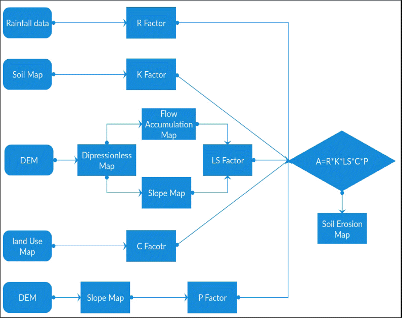
Flowchart showing soil loss estimation procedures
RUSLE computes the annual average soil loss as:
Where, A = the estimation of soil loss amount Mega gram per hectare per year (Mg or tons ha-1 year-1), R = rainfall erosivity factor in mega joule of millimeter per hour per hectare per year (MJ mm h-1 ha-1 year-1), K = soil erodibility factor in mega gram per hectare per mega joule per millimeter (Mg or tons ha-1 MJ-1 mm-1), LS = topography factor (dimensionless), C = cover-management factor (dimensionless) and P = conservation practice factor (dimensionless).
2.3 Description of Soil Erosion Parameters
2.3.1 Rainfall-runoff erosivity factor (R)
The rainfall-runoff erosivity factor (R factor) describes the probable erosion capability of rainfall on soil (Renard et al., 1991). which is related to amount, intensity and duration of rainfall along with size and velocity of raindrops. Although R factor has been shown to be the index largely correlated with soil loss throughout the world, many alternative erosivity indices have been shown in literature to more greatly correlate to soil loss for particular locations and scales (Renard & Freimund, 1994). So as to evaluate R factor, Singh et al., (1981) approach recommended for Himalayan region was applied which states that:
Where, R = rainfall erosivity factor (MJ mm ha-1 hr-1 year-1), P = mean annual precipitation in mm.
For this purpose, average annual precipitation data from 8 rain gauge stations were acquired from Department of Hydrology and Meteorology (DHM), Nepal with two stations (Markhugaun and Daman) within the catchment area and other stations lying in the vicinity as presented in Table 2. These values of R has been generalized using the “IDW” interpolation method in the ArcGIS software.

Precipitation data
2.3.2 Soil Erodibility Factor (K)
The soil erodibility factor (K) reflects the soils sensitivity towards erosion. K factor for the study watershed was estimated based on soil unit types mentioned from Food and Agriculture Organization (FAO) soil database adapted to Nepal by World Soil Information (ISRC). In order to calculate K-factor, GIS environment was used to obtain soil unit’s map of watershed which was derived from Soil and Terrain (SOTER) database for Nepal (Dijkshoorn & Huting, 2009) map at 1:50,000 scale.
2.3.3 Topography Factor (LS)
A depression less DEM is required to perform the necessary steps in finding the LS factor in which there are no sinks present (Cooley, 2015). A 30 m spatial resolutions digital elevation model (DEM) was used to generate slope which was derived from the ASTER (GDEM). “Spatial Analyst Tool>Surface Slope” and “ArcHydro Tool” in ArcGIS 10.2 environment were applied for subsequent steps in calculating LS factor. Finally, spatially distributed value was determined using an equation proposed by Cooley (2015) as in equation (3):
Where: flow acc = flow accumulation
2.3.4 Cover Management Factor (C)
The combined effect of vegetation cover, management on soil loss is reflected by C factor values. A land use GIS shape file derived from ICIMOD (2013) was clipped to get surface coverage condition of watershed. Values shown in Table 3, proposed by Panagos et al. (2015) were adopted with incorporating local condition, to prepare C factor map.

Cover management values
2.3.5 Conservation Practice Factor (P)
P values are determined by the extent of individual conservation practices, such as contouring, strip cropping and terracing, which can also be used in combination. Slope percentage map was prepared using “Spatial Analyst Tool>Surface Slope” in GIS environment using DEM which was derived from the ASTER GDEM. According to cultivation method and slope, the following P factor values were used as described by Shin (1999):
3. Results and Discussion
3.1 Determination of Soil Loss Parameters
3.1.1 Rainfall Erosivity Factor (R)
Rainfall erosivity factor is difficult to determine directly. The average annual rainfall of catchment area is 1863 mm. Average R factor value ranged from 609.34 to 768.97 MJ mm h-1 ha−1 year−1 with average 696.75 MJ mm h-1 ha−1 year−1. Spatial distribution of R factor value of basin area was produced in the form of a rainfall erosivity factor map as shown in Fig. 3(a).
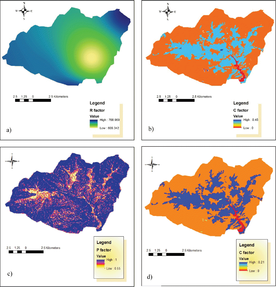
Spatial distribution map of a) R factor, b) K factor c) P factor and d) C factor
3.1.2 Soil Erodibility Factor (K)
Soil erodibility is a measure of a soil resistance to the erosive powers of rainfall energy and runoff. K factor represents the susceptibility of a soil type to erosion i.e. it is the reciprocal of soil opposition to erosion (Hudson, 1993). It is highly related with soils mechanical composition and organic matter content. The results indicated that soils of watershed are dominated by two types as; Eutric Cambisols and Chromic Cambisols. According to Vopravil et al. (2007), soil erodibility value adopted to Eutric Cambisol is 0.32 Mg h MJ−1 mm−1 and average value of 0.33 Mg h MJ−1 mm−1 of Cambisols is adopted for Chromic Cambislos. The soil distribution and soil erodibility map is presented in Fig. 3(b).
3.1.3 Cover Management Factor (C)
Cover management factor (C factor) describes conditions that can be managed most easily to reduce erosion (Renard et al., 1991). Five land cover classes were documented in the watershed, pre-dominated by forest (71.13%) and agriculture farm (27.21%). The C-factor value in Kulekhani watershed, based on available data, varies from 0 to 0.45, with a relatively low mean value of 0.03 as in Fig. 3(c). In order to improve data, further research is essential with satellite images of enhanced geometric and spatial characteristics as well as real field investigations to better correlate the C-factor with remote sensing data.
3.1.4 Conservation Practice Factor (P)
Conservation management factor (P factor) refers how surface conditions affect flow paths and flow hydraulics (Renard et al., 1991). The P-factor value varies from 0 to 1, and the mean value is 0.93 (Fig. 3(d)) where 0 reflects to the regions without erosion, and 1 reflects to the region which needs maximum care to planning conservation measures.
3.1.5 Topography Factor (LS)
In RUSLE, the effect of topography on soil loss is represented by L and S factors where, S factor reflects the change in potential erosion with change in slope, and L factor reflects increasing potential erosion due to surface runoff. The upslope catchment area for each cell in a DEM was computed with number of steps. LS-factor values in the study watershed varies from 0 to 577.88 and mean 13.211. The performed steps and spatial distribution of LS factor is as shown in Fig. 4.
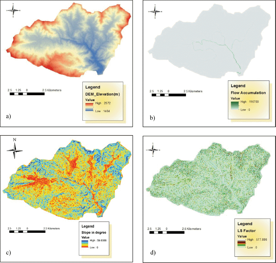
Steps followed to compute LS factor maps: a) DEM, b) Flow Accumulation, c) Slope map and d) LS factor map
3.2 Soil Erosion Estimation
Based on the analysis using RUSLE, GIS and Remote Sensing, average potential soil erosion of Kulekhani watershed was found to be 195.11 metric tons per hectare per year (Mg or tons ha-1 year-1). Obtained average annual soil loss distribution was subsequently grouped into six erosion intensity classes (slight, moderate, high, very high, severe and very severe) as per guideline by Singh et al., (1992). The result from soil erosion analysis designated in Table 5 reveals that about 41% area of the watershed is under category of slight erosion and about 58% of area is under category of high to severe erosion. This area under the range of high to severe soil erosion potential needs immediate conservation measures. Since, the spatial distribution map of soil erosion as displayed in Fig. 5, indicates that the soil erosion of high to very severe classes is scattered all over the catchment area, therefore conservation measures should be carried out over whole catchment extent.

Area covered by different classes of soil erosion
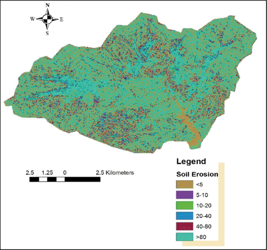
Spatial distribution of soil erosion map

Support practice values
4. Conclusions
Soil erosion from Himalayan region is the serious problem in Nepal especially during monsoon season. This study demonstrated that the RUSLE together with GIS and RS and estimates soil loss rate spatially in the middle Himalayan zone of Nepal. The predicted amount of soil loss and its spatial distribution could facilitate sustainable land use management of catchment area and hence to preserve the healthy water in the Kulekhani reservoir. This method can also be applied in similar watershed with in the country. Soil erosion mapping can give very good demarcation for the erosion prone area prioritization. A soil loss of up to 15 t ha·1 year-1 is considered tolerable in mountainous areas of the Himalaya (Jasrotia & Singh, 2006). As compared to this threshold, the average yearly soil erosion of 195.11 Mg ha-1 of the study catchment area is quite high. Areas characterized by high to very severe soil erosion should be given special preference to control the rate of soil erosion through suitable conservation practices. Nevertheless, the accuracy of outcomes obtained is largely dependent on the accuracy of different input data such as rainfall data (R factor which requires 30 minute interval rainfall heights) and soil erodibility index (K factor) are location specific and need to be calibrated.
Acknowledgment
This research was supported by a grant(13SCIPS04) from Smart Civil Infrastructure Research Program funded by Ministry of Land, Infrastructure and Transport(MOLIT) of Korea government and Korea Agency for Infrastructure Technology Advancement(KAIA).