Analysis of Natural Disaster Risk based on Flood, Wind and Snow Risk
Article information
Abstract
This study developed flood, wind and snow risk map, after which an integrated natural disaster risk map of Daegu, Ulsan, Gyeongbook and Gangwon was generated. A 100-year flood inundation map was used for developing flood risk map and the results show 670 km2 (1.8%) of the whole 36,860 km2 study area was flooded. While for a 100-year wind velocity frequency mapping, results showed a range of 19.3 m/s to 59.9 m/s. For 100-year snow load frequency, the results ranged from 0.31 kN/m2 to 7.53 kN/m2. Four levels of risk were used to identify the flood risk namely: Safe, Warning, Dangerous and Severely Dangerous. These levels represents the degree of damage caused by flood to buildings and people lives. The same levels of risk were adopted for the determination of wind and snow risk. Integrated natural disaster risk map was developed by applying weights calculated from flood, wind and snow damage according to administrative districts to each risk map.
Trans Abstract
본 연구에서는 대구, 울산, 경북, 강원 지역을 대상으로 수해, 풍해, 설해 각각의 위험지도를 개발하였고 통합된 자연재해 위험지도를 개발하였다. 수해위험지도 작성을 위해 100년빈도 홍수범람지도가 활용 되었고, 홍수범람지도 분석 결과 연구대상지역 36,860 km2 중 1.8%인 670 km2가 침수 되는 것으로 분석되었다. 풍해위험지도 작성을 위해 100년 빈도 풍속을 산정하였고 그 결과, 최소풍속은 19.3 m/s, 최대풍속은 59.9 m/s로 분석되었으며 설해 위험지도 작성을 위해 100년 빈도 적설하중을 산정하였고 최소적설하중은 0.31 kN/m2, 최대적설하중은 7.53 kN/m2로 산정 되었다. 홍수위험도를 안전, 경계, 위험, 매우위험 4개 등급으로 구분하였고 이 4개의 등급은 홍수에 의한 건물과 사람의 피해 정도를 나타낸다. 동일한 4개의 등급이 풍해, 설해 위험도를 결정하는데 적용되었다. 수해, 풍해, 설해 위험도가 통합된 자연재해 위험지도는 행정구역별 수해, 풍해, 설해의 과거 피해액으로부터 산정된 가중치를 적용하여 개발되었다.
1. Introduction
Recently, natural disasters such as flood, wind, snow and earthquake damages have occurred frequently all over the world. From January 22-24, 2016, a major blizzard produced up to 91 cm of snow in parts of the Mid-Atlantic and Northeast United States (Chicago Tribune, 2016; The Washington Post, 2016). The governors of the eleven states and the mayor of Washington, D.C. declared a state of emergency due to the extreme snowfall and blizzard conditions. Approximately 103 million people were affected by the storm and of which 33 million people were under blizzard warnings and more than 13,000 flights were cancelled in relation to the storm’s rippling effects. The total economic losses were estimated ranging from $500 million to $3 billion. Also, extreme flooding has occurred in Thailand at the end of March 2011, which normally takes place on the latter part of the dry season of the country. Heavy rain fell in the southern region, with over 120 cm (47 in) of rain falling in certain areas (NASA Earth Observatory, 2011). At least 53 people died and almost 9 million people were affected by the floods after localized heavy rains which has affected 50 of Thailand’s 76 provinces (New Zealand Herald, 2011). Close to 160,000 ha (400,000 acres) of land have been submerged (Bernama Malaysian National News Agency, 2011). Around 5,000 households have been evacuated, (MCOT, 2011) with the inclusion of hundreds of tourists (The Nation, 2011). Typhoon Haiyan, known as Super Typhoon Yolanda in the Philippines, devastated portions of Southeast Asia, particularly the Philippines, on November 8, 2013 (NPR, 2013). According to the Philippine government, a total of 16 million people were directly affected by the super typhoon and of which 6,300 were killed, 4.1 million were displaced and 1.1 million houses were damaged or destroyed. It is also recorded as the strongest typhoon which sustained a wind speed of 315 kph (195 mph). Recovering from this typhoon will take time due to its adverse effects and lack of the financial ability to rebuild the damages brought about by Typhoon Haiyan. Typhoon Maemi, was the most powerful typhoon in 2003 to strike South Korea since record-keeping began in the country in 1904. This event has recorded a total of 132 people dead and missing, 61,000 people directly affected by the typhoon and a total damage of about 3.9 billion won. In terms of snow, there was a 50 cm wet snowfall with a density of about 300 kgf/m3 in February, 2014 in Gyeongju, Korea. This event caused a resort hall’s roof to collapse killing 10 people and leaving 128 people with severe wounds from the accident. Among natural disasters in Korea, typhoon took the largest toll at 26% followed by torrential rain at 52% and heavy snow at 20% for the last decade and this requires urgent countermeasures (NEMA, 2003-2012).
Assessment of regional natural disaster risk is very important to prevent and mitigate such natural disaster. Disaster risk assessment is considered an effective means of solving natural disaster (Hallegatte et al., 2013), and therefore has been widely applied to natural disaster insurance, floodplain management, disaster warning systems, and evacuation planning, proving to be an important scientific reference for flood disaster risk management and relevant decision-making (Zou et al., 2013). Various researches have been performed to evaluate natural disaster risk. In order to assess natural disaster risk, numerous systematic methods such as the analytic hierarchy process (AHP) (Fernández and Lutz, 2010; Stefanidis and Stathis, 2013; Yang et al., 2013), set pair analysis (SPA) (Zou et al., 2013; Guo et al., 2014), and fuzzy comprehensive evaluation (FCE) (Jiang et al., 2009; Li, 2013; Lai et al., 2015) have been applied to this field, with mixed results (Wang et al., 2015). Federal Emergency Management Agency (FEMA) released HAZUS-MH that can estimate four types of hazard risk: flooding, hurricanes, coastal, surge, and earthquakes. A variety of research on disaster vulnerability has been performed to analyze natural disaster risk (Connor and Hiroki, 2005; Barroca et al., 2006; Rygel et al., 2006; Balica et al., 2009; Fekete, 2009). The studies of developing flood inundation map, wind speed and snowfall map and their risks have been continuously performed (Lee et al., 2011; Shin et al., 2014; NEMA, 2009; Yu et al., 2014).
Although there has been an intensive variety of research related to flood such as development of flood inundation map, flood risk map, and development of flood early warning system, studies related to wind and snow damage has been very deficient. Several research regarding flood, wind and snow have already been performed, but an integrated natural disaster risk assessment combining these disaster has not been researched yet.
In this study, disaster risk for flood, wind and snow which comprises the majority of the natural disaster damage in Korea were analyzed, after which an integrated natural disaster risk map was developed. This map is expected to identify areas that are vulnerable to various natural disasters. Policymakers could come up with proper countermeasures against these sorts of natural disasters using the developed natural disaster risk map. Therefore, this integrated natural disaster risk map would serve as a decision-making tool for policymakers, researchers and government officials in setting priorities for countermeasures that are needed for the mitigation and prevention of natural disasters. Regional natural disaster risk would also be used to calculate reasonable natural disaster insurance rate for restoration.
2. Research Method
2.1 Study Area
Daegu, Gyeongbuk and Gangwon, located on the northeastern part of Korea as shown in Fig. 1 were selected as study areas for this research. The characteristics of these areas such as area in km2, population, average precipitation in mm, average temperature in Celsius, and average annual wind speed in m/s and average annual snowfall in cm are listed in Table 1 for the analysis and development of risk map.
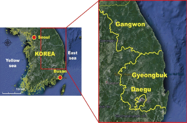
Location of Selected Study Areas
Characteristics of the Selected Regions for Risk Analysis
2.2 Method for the Development of Flood Risk Map
In order to develop a flood risk map, a flood inundation map must first be developed. For this research, the developed inundation map refers to those submerged areas due to overflowing of rivers. Damage incurred to the structures and human life were then classified according the four categories illustrated in the flood risk map.
2.2.1 Flood Inundation Map
There are various ways to develop the flood inundation map such as the use of numerical analysis models and GIS program through flood level and topographic data (NEMA, 2014). Compared to GIS program, numerical analysis model is more accurate but it is limited to small range of areas. On the contrary, GIS program can cover a wide range of areas, but with less accurate results. GIS program has the advantage of evaluating the total study area of 36,860 km2 and a river as long as 8,486.87 km2 as shown in Table 2. Therefore, shape file format was made based from the data of the flood inundation map of the 810.52 km national rivers produced from HEC-RAS (one-dimensional) and FLUMEN (two-dimensional) models that were developed by the Ministry of Land, Transport and Maritime Affairs. However, the same model cannot be used for the local river which is 7,676.35 km long. Due to its wider range, the flood inundation map for local river was developed using the GIS program. Digital Elevation Map (DEM) of both the study area and the 100-yr flood inundation are needed to develop an inundation map using the GIS program. Areas where flood level DEM is higher than that of the topographic DEM were used to get the inundation depth.

Scopes of National and Local Rivers
2.2.2 Flood Risk Map
Flood risk map is developed based on the inundation map, then the risk intensity is classified according to inundation depth. MPSS (2015) classifies flood risk as shown in Table 3 which was applied in this study. Table 3 shows the classifications of flood risk map that states that for a depth of 0 it is considered Safe, a range of 0.0 - 0.5 indicates Warning, 0.5 - 1.0 signifies Dangerous and more than one implies Severely Dangerous intensity.

Classification of Flood Risk
2.3 Method for the Development of Wind Risk Map
The wind risk map was developed from the application of the design wind velocity calculation method suggested by the Korean Building Code of Ministry of Land, Infrastructure and Transport (MLIT, 2009) and the wind velocity estimation method described in the Development of Risk Assessment Technique for Strong Wind and Heavy Snowfall of National Emergency Management Agency (NEMA, 2009). The first model developed for the wind risk map was the Homogeneous Wind Model. This model provides the value of the velocity when the elevation and roughness are not applicable. The same goes with the surface roughness and topographical effect model. Also, for the Homogeneous Wind Model, the surface roughness and topographical effect models were applied to it to develop a wind velocity map which has the same four classifications as the previous table mentioned.
2.3.1 Homogeneous Wind Model
This model, through the use of velocity frequency analysis was developed without the use of surface roughness and topographical effect. For the velocity frequency analysis, an annual maximum wind velocity data with a record of more than 20 years was used, while for the probability distribution analysis Gumbel distribution was used. Also, the moment method was used for the parameter estimation. Gumbel’s cumulative probability distribution is shown in Eq. (1), while the calculation for x and the inverse function of F(x) are revealed on Eq. (2).
Where x, x0 and a are variance, positional parameter and shape parameter, respectively. The calculation of the wind velocity using Eq. (2) will no longer need or take into account the usage of surface and topography parameters on the Homogeneous Wind Model.
2.3.2 Surface Roughness Model
Usually the earth’s surface roughness is affected by the velocity of wind. Here, the Surface Roughness Model signifies that the weight on the surface roughness depends on the unpredictable change of the wind velocity. Korean Building Code (MOLIT, 2009) categorizes the surface roughness with regards to the height of the structure or land. If the region has a building with a height greater than 10-storey then the roughness result is 0.58, for those that are at a height of 3.5 m the roughness is 0.81, a height of 1.5 m produces a 1.0 roughness and the last category which is the coast, grassland and aerodrome regions has a surface roughness of 1.13. All are dimensionless.
2.3.3 Topographical Effect Model
Areas located in between hills and slopes has a higher wind velocity as compared to others. The model estimates the increasing rate of velocity which depends upon the features of topography. To assess the growing rate quantitatively, Korean Building Code (MOLIT, 2009) recommends that the use of topographic factors is dependent on the topography of hills, slopes, mountains and lands. The factors which ranges from 1.05-1.27 is applicable for sloped lands, on the other hand, a range of 1.11-1.61 is for hills and mountains. The speed that is supplemented by topography can be estimated by multiplying the velocity of the homogeneous wind model to the topographic factors.
2.3.4 Wind Risk Map
In this study, a comparison of the 100-year velocity frequency developed from the homogeneous wind, surface roughness and topographical effect models are required for the development of a wind risk map. It is based on the Korean Building Code (MOLIT, 2009) which states that the velocity frequency as a standard for designing structures. Table 4 shows that when the wind risk is equivalent to 0, the intensity is within a Safe zone, for those which are on the range of 0 but less than 1, a Warning status is indicated. A wind risk ranging from 1 but less than 1.5 declares a Dangerous status and greater than 1.5 has a mark of Severely Dangerous status.

Classifications of Wind Risk
2.4 Method for the Development of Snow Risk Map
The use of an annual maximum snowfall which was observed by the meteorological station is required for frequency analysis to develop a snow risk map of the study area. A 10-m grid based snowfall map is created through the application of the unit weight of snow fall and the frequency analysis.
2.4.1 Snowfall Frequency Analysis
In computing for the probability of snowfall, a snowfall frequency analysis was done. The construction of an annual maximum snowfall data requires at least 20 years or more of historical data which was used for the development of snowfall frequency, probability distribution and parameter estimation method. This will help in selecting the best fit for the analysis of snowfall. Various probability distributions for extreme and ordinary frequency analysis are present nowadays. One is the Snow load frequency analysis which applies the Generalized Extreme Value, Type-I (Gumbel), Type-II (Log-Gumbel) and Type-III (Weibull), Log- Pearson Type-III. The most fitting for snowfall frequency analysis is the Generalized Extreme Value, while the most frequently used in Korea is the probability weighted moment method (Yu et al., 2014). This research also used GEV from the moment method to execute snowfall frequency analysis, wherein the probability density function of GEV is Eqs. (3) and (4) is the variance that depends on the return period.
where a is the scale parameter, b is the shape parameter, x0 is the positional parameter and T is the return period.
2.4.2 Snow Load
Snowfall frequency analysis is made through the multiplication of unit weight of snow with the 100-year snowfall. As illustrated in Fig. 2, the relation of first 50 cm snowfall with the 100 kg/m3 unit weight has a horizontal and constant line. However as both parameters increases until 200 cm for snowfall and 250 kg/m3 for the unit weight, it indicates a diagonal increasing movement, then maintains a straight horizontal line after the 200 cm mark for the snowfall.
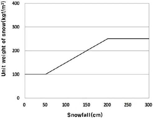
Unit Weight of Snow According to Snowfall
2.4.3 Snow Risk Map
An assessment connecting the 100-year snowfall through the use of snowfall frequency analysis and the design of snow load for the study area is required to develop a snow risk map. Table 5 shows four classifications of snow risk for the awareness of the public. A value of 0 for the snow risk indicates a Safe zone, a range between 0 to 1.0 signifies a Warning, while a range of 1.0 but less than 1.5 symbolizes a status of Dangerous and last but not the least a snow risk higher than 1.5 results for a Severely Dangerous area and is not fit.

Classifications of Snow Risk
3. Results And Discussion
3.1 Results from the Development of Flood Risk Map
A 10m grid-based flood risk map, as shown in Fig. 3, was made for the development of flood inundation map of Daegu, Gyeongbuk and Gangwon using both numerical and GIS models. Out of the total study area of 36,860 km2, only 670 km2 was found to be inundated and the remaining 36,190 km2 was founded to be safe. This also showed that a 125 km2 area was associated with the second level which is on a warning zone with depths ranging from 0 m to 0.5 m, an area of 163 km2 for the dangerous zone with depth range of 0.5 m to 1.0 m and lastly an area of 382 km2 for the severely dangerous with range of 1.0 m or more.
Flood Risk Map
3.2 Results from the Development of Wind Risk Map
The three models namely: Homogeneous wind, Surface roughness and Topographical effect are used to develop the wind risk map. The 10m grid-based wind risk map is shown in Fig. 4 where the maximum and minimum velocity observed is 19.3 m/s and 59.5 m/s, respectively. Also, this signifies that there were no Safe areas and that for the Warning status it has a total area of 12,095 km2, the Dangerous status indicated an area of 24,510 km2 and lastly the Severely Dangerous incurred a total of 255 km2 of the total study area.
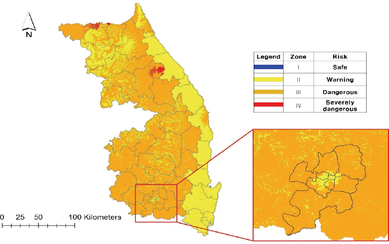
Wind Risk Map
3.3 Results from the Development of Snow Risk Map
A 100-year snow load map using the snowfall frequency analysis was developed and the 10m grid-based snow risk map is shown in Fig. 5 which has a minimum and maximum snow load of 0.31 kN/m2 and 7.53 kN/m2, respectively. This result indicates that there were also no Safe areas. The Warning zone has a total of 27,785 km2, while the Dangerous zone incurred an area of 7,678 km2 and lastly the Severely Dangerous has a total of 1,397 km2 from the whole study area.
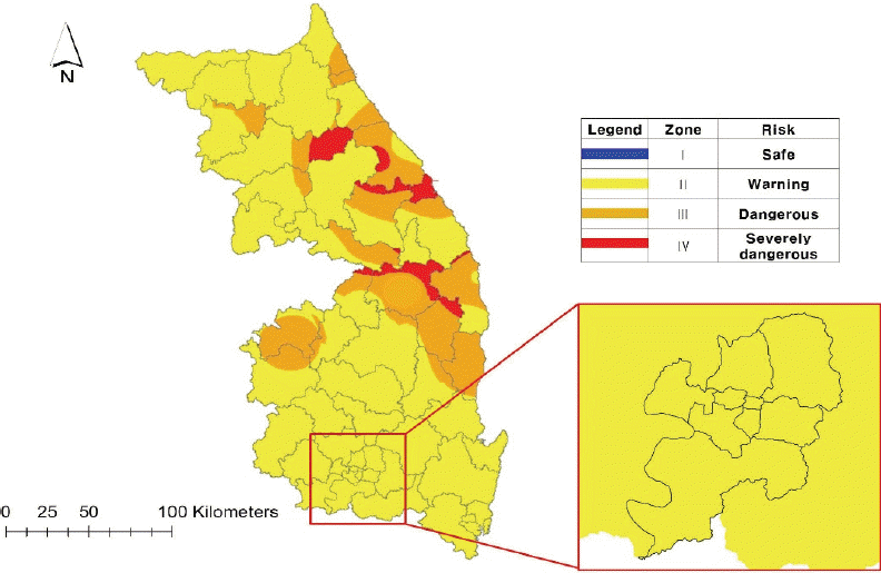
Snow Risk Map
3.4 Results from the Development of Integrated Natural Disaster Risk Map
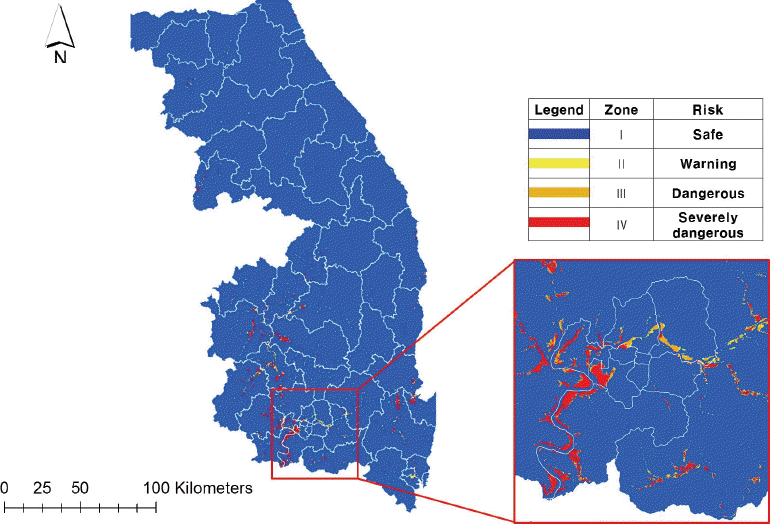
Table 6 explains the weights given per region and per damage from 2006-2014 which must sum up to 1. The Daegu region, for example only contains flooding damages, while for the Gyeongbuk and Gangwon area, all three damages exist. In the Table 6, it is also noticeable that the most weight comes from the flood damage making it the most dominant or prominent among the three. In Fig. 6, which is the integrated natural disaster risk map, where all the three risks: flood, wind and snow were combined, it indicates that for the four different zonal risks, the following areas were computed and calculated: Safe summing up to 36,177 km2, Warning having 261 km2, Dangerous with 374 km2 and Severely Dangerous with 48 km2. It may then be concluded that a lot of areas or places are still under safe zones and from the other areas where threats have been determined specifically, a countermeasure or preventions can be made for the safety of the lives of the people around these areas.

Weight of Flood, Wind and Snow Damage for Integrated Natural Disaster Risk Map
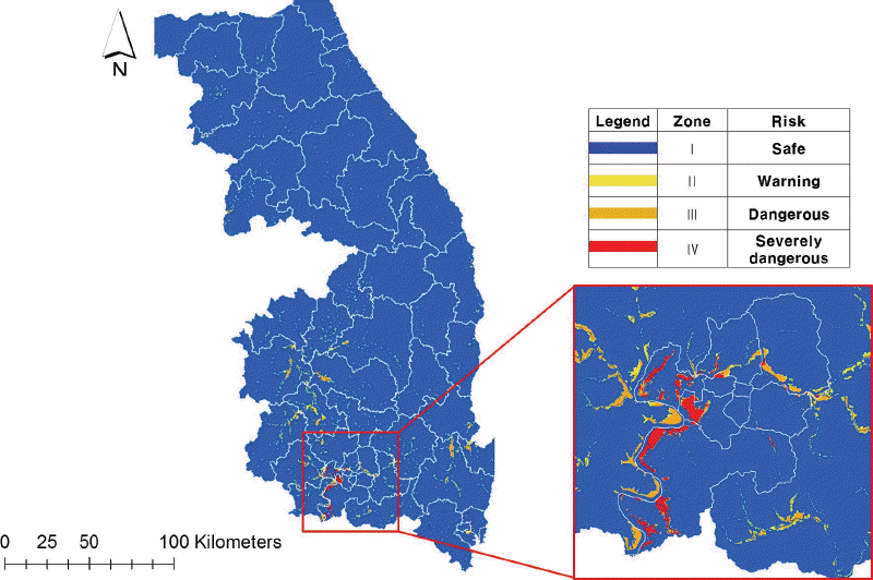
Integrated Natural Disaster Risk Map
4. Conclusion
This study developed the flood, wind and snow risk map of Daegu, Gyeongbuk and Gangwon. One-dimensional and two-dimensional numerical modeling was applied to national rivers while GIS technique that used flood level was applied to local rivers to develop the flood inundation map. It was analyzed that 670 km2 (1.8%) of the city were submerged out of the total 36,860 km2 and the remaining 36,190 km2 (98.1%) were classified as Safe areas. The study also showed that, area under Warning zone with a depth of 0 m to 0.5 m is about 125 km2 (18%), Dangerous zone with a range of 0.5 m to 1.0 m was 163 km2 (48%) and Severely Dangerous at more than 1.0 m was 382 km2 (34%).
For the development of the wind risk map, the wind velocity estimation method suggested by Korean Building Code (2009) was applied to generate homogeneous wind model, surface roughness model and topographical effect model and develop the wind velocity map of Daegu, Gyeongbuk and Gangwon. The 100-year minimum and maximum wind velocity of the study area were estimated to be 19.3 m/s and 59.9 m/s, respectively. This shows that there were no Safe areas. For the Warning zone, the area covered was 12,070 km2, for the Dangerous zone an area of 24,535 km2 and for the Severely Dangerous it had incurred a total of 255 km2.
On the other hand, snowfall frequency analysis was performed to develop 100-year snow load and snow risk maps. The minimum and maximum snow loads were estimated to be 0.31 kN/m2 and 7.53 kN/m2, respectively. There were also no Safe areas. Warning zone has an area of 11,795 km2, the Dangerous zone has a total of 14,744 km2 and lastly, the Severely Dangerous zone had acquired an area of 10,321 km2.
Integrated natural disaster risk map of Daegu, Geongbuk and Gangwon was developed by combining flood, wind and snow risk applying each weight that is calculated from monetary damage for 2006-2014. The map has 4 different zonal risks: Safe summing up to 36,177 km2, Warning having 261 km2, Dangerous with 374 km2 and Severely Dangerous with 48 km2. It may then be concluded that a lot of areas or places are still under safe zones and from the other areas where threats have been determined specifically, a counter- measure or preventions can be made for the safety of the lives of the people around those areas.
The developed natural disaster risk map is expected to detect an area vulnerable to various natural disasters. Policymakers could come up with proper countermeasures against these sorts of natural disasters using the each natural disaster risk map. Therefore, this integrated natural disaster risk map would serve as a decision-making tool for policymakers, researchers and government officials in setting priorities for countermeasures that are needed for the mitigation and prevention of natural disasters. Regional natural disaster risk is going to be also used to calculate reasonable natural disaster insurance rate for restoration.
Acknowledgement
This research was supported by a grant [MOIS-DP-2013-01] through the Disaster and Safety Management Institute funded by Ministry of the Interior and Safety of Korean government.