Feasibility Study of Deriving Areal Reduction Factor for Storm Design Application in Malaysia Using Satellite Rainfall Products
Article information
Abstract
This study presents the feasibility of deriving areal reduction factor (ARF) for storm design application in Malaysia using satellite rainfall products. It is required to review the ARF estimations in Malaysia as some shortcomings have been noticed in the existing technical manual. This study attempted to merge observed rainfall data from rainfall stations with satellite rainfall products for derivation of ARF as conventional ground based rainfall monitoring networks have the major drawback of limited rainfall measuring coverage over large spatial extent especially for sparse monitoring networks. To this end, annual maximum areal rainfall for interval of 1-hour, 3-hour, 6-hour, 12-hour, and 24-hour have been computed from nine rainfall stations located within the study area and the corresponding satellite rainfall products were also extracted for rainfall clustering analysis. The observed rainfall data were merged with satellite rainfall products of Precipitation Estimation from Remotely Sensed Information using Artificial Neural Networks - Cloud Classification System (PERSIANN-CCS) using several merging techniques which are Geographical Differential Analysis (GDA), distribution transformations, and regression analysis. GDA approach was identified as the best merging technique over the others as it yielded most promising results when correlating with observed rainfall data with average R2 of 0.603 and RMSE of 8.150. It is found out that GDA was able to model maximum rainfall amount as observed in the rainfall stations while the other merging techniques were failed to do so. It is noticed from the rainfall clustering analysis that the average threshold radius obtained for observed rainfall data of fixed boundary area of 1,024 km2 was smaller than the one obtained for satellite rainfall products. This implies that spatial distribution of satellite rainfall products was more homogenous than observed rainfall data. Thus higher values may be obtained from ARF derivation using satellite rainfall products.
Trans Abstract
본 연구에서는 인공위성 강우를 이용한 말레이시아의 설계호우 면적감소계수(ARF)에 대한 타당성을 제시하고자 한다. 말레이시아의 경우 기존의 기술 매뉴얼에 대한 검토로 부터 몇 가지 단점이 발견 되었으므로 면적감소계수의 산정방법을 검토하여야 한다. 본 연구는 기존의 지상 기반 강우 관측망이 넓은 공간 범위에 대하여 제한된 강우량 측정 범위를 갖는 단점을 보완하기 위하여 강우 관측소에서 관측된 강우 자료와 인공위성 강우를 병합하여 면적감소계수를 유도하고자 시도하였다. 이를 위해 연구 지역내에 위치한 9 개의 강우 관측소에서 1 시간, 3 시간, 6 시간, 12 시간 및 24 시간 간격으로 연간 최대 면적 강우량을 계산하였으며 동일 기간에 대한 인공위성 강우를 강우 군집 분석을 위하여 추출하였다. 관측된 강수 자료는 여러 가지 병합 기법을: Geographical Differential Analysis (GDA), 분포 변환(Distribution Transformations), 회귀 분석(regression analysis) 이용하여 PERSIANN-CCS로부터 추출된 인공위성 강우와 합병하였다. GDA 기법으로 병합한 강우 자료가 가장 좋은 결과를 산출 하였으므로(평균 상관 계수는 0.603, 평균 제곱근오차는 8.150) 다른 병합 기법에 비해 가장 우수한 방법으로 확인되었다. GDA는 강수 관측소에서 관측된 최대 강수량을 모델링 할 수 있었지만 다른 병합 기법은 그렇지 못하는 것이 밝혀졌다. 강우 군집 분석 결과에 따라 1,024 km2 지역내에서 관측된 강우 자료의 경우 평균 임계 반지름은 인공위성 강우에 비하여 작음을 알 수 있었다. 이는 인공위성 강우의 공간 분포가 관측된 강우 자료보다 균질하다는 것을 의미한다. 따라서 인공위성 강우로 부터 도출하는 면적감소계수가 더 높은 값을 얻을 수 있었다.
1. Introduction
Design rainfall is the primary design parameter required for any design storm applications. It is estimated from point rainfall collected from the ground based rainfall stations in the past to the applications of satellite and radar in the present. However, rainfall is not evenly distributed over a catchment area spatially and temporally and thus concept of areal reduction factor (ARF) has been introduced to describe the spatial characteristic of rainfall over a large catchment area and it is used to convert a point rainfall to areal rainfall.
Alexander (2001) defines that ARF is used to convert design point rainfall depths/intensities of larger areas into an average areal design rainfall depth/intensity for a particular critical storm duration and catchment area. Areal reduction factor is applied to avoid over or under-estimation of design rainfall for a large catchment based on point design rainfall. The concept of ARF was firstly proposed by USWB (1957) for design storm applications in United States of America and followed by NERC (1975) in United Kingdom. These two studies had been deemed as the core references for development of ARF since their debuts. However, many scholars are skeptical about the methodologies and assumptions proposed in these studies due to the variation in predominant weather types, storm durations, seasonal factors and recurrence interval (Pietersen et al., 2015). Omolayo (1993) concluded that insufficient short duration rainfall data and incomplete rain-gauge networks would lead to impromising estimation of ARF. Also it is concluded from the same study that storm-centred approaches are not recommended to compute ARF for converting design point rainfall to areal design rainfall due to the reason of extreme design point rainfall and extreme areal design rainfall are impossible to be generated by the identical rainfall event or rainfall type. Difficulty in identifying multi-centred storms also limits the estimation of ARF using storm-centred approaches (Asquith and Famiglietti, 2000). There is a concern that NERC (1975) is only applicable in United Kingdom and may not be usable in other regions (Pietersen et al., 2015). Many advanced analytical approaches for ARF estimation have been developed since then which include storm movement (Bengtsson and Niemczynowicz, 1986), crossing properties (Bacchi and Ranzi, 1996), spatial correlation structure (Sivapalan and Bloschl, 1998), and scaling relationships (De Michele et al., 2001). Even though many new approaches have been developed, practitioners are still referring USWB (1957) and NERC (1975) for ARF estimation as these new approaches are developed based on insufficient amount of observed rainfall data and the assumptions made are not able to describe the actual rainfall process (Svensson and Jones, 2010). Therefore until now there are still many inconsistencies in estimating ARF.
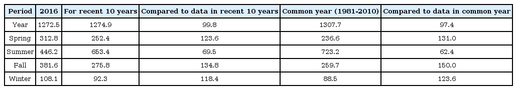
Two authoritative reference documents entitled with Water Resources Publication No.17: Variation of Rainfall with Area in Peninsular Malaysia (DID, 1986) and Review and Updated the Hydrological Procedure No.1: Estimation of Design Rainstorm in Peninsular Malaysia (NAHRIM, 2010) have been regarded by most of the practitioners for hydrological studies of local concerns. However, there are some shortcomings in these guidelines which need to be reviewed. Kok et al. (2017) conducted several statistical tests and the results revealed that increasing trends have been observed for annual maximum rainfall amount of certain rainfall interval recorded in the rainfall stations which are located in the study area. Therefore, the ARF presented in existing technical manual which was derived using past rainfall data might not be appropriate to describe present changing rainfall characteristic.
Conventional ground based rainfall monitoring networks have the major weak point of limited rainfall measuring coverage over large spatial extent especially for sparse monitoring networks. To this end, measuring rainfall using remote sensing techniques has been prevailing nowadays to overcome the limitations of conventional ground based rainfall stations. Rainfall measuring using remote sensing can be divided into radar sensing and satellite sensing. However, measuring rainfall using remote sensing also has certain drawbacks. Underestimation of satellite product is more severe over areas of high rainfall amounts which is known as the weakness of thermal infra-red (TIR) based retrieval algorithms (Kidd and Huffman, 2011). Therefore, the raw satellite rainfall products have to be bias corrected before using it for further applications and merging the satellite data with the rain gauge data can allow for correction of the errors induced by the sampling frequency, sensor limitations, and the retrieval algorithm (Manz et al., 2016).
In view of the above discussion, this study presents the feasibility of deriving areal reduction factor (ARF) for storm design application in Malaysia using satellite rainfall products. Rainfall clustering analysis will be carried out to determine rainfall spatial distribution for both observed rainfall from rainfall stations and satellite rainfall products. Several satellite rainfall merging techniques are applied to merge the satellite rainfall products with the observed rainfall data and each technique is evaluated using several performance analysis in order to identify the optimal merging technique.
2. Description of Study Area and Rainfall Products
Kuala Lumpur is the capital of Malaysia which is located at the west coast of Peninsular Malaysia between N3°02’- N3°14’, and E101°36’- E101°45’ as illustrated in Fig. 1. Due to its equatorial geographical location, Kuala Lumpur experiences a hot and humid tropical climate throughout the year characterized by high annual rainfall, humidity, and temperature. Its range of annual rainfall is between 2000 to 4000 mm and the annual number of wet days ranges from 150 to 200 (Suhaila et al., 2010). The climate of Peninsular Malaysia can be described by two major monsoons which are southwest monsoon starting from May to August annually and northeast monsoon starting from November to February annually. Kuala Lumpur is located at the west coast of Peninsular and thus it receives the influence of southwest monsoon. It is reported that there are four rainfall regions in Peninsular Malaysia which are northwest, west, southwest, and east (Lim and Azizan, 2004) and Kuala Lumpur is located at the west rainfall region as illustrated in Fig. 1.
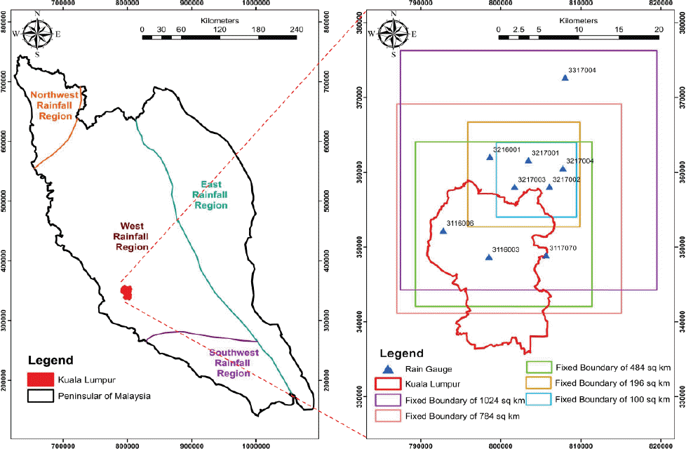
Geographic Location of Study Area (Kuala Lumpur), Locations of Rainfall Stations, and Proposed Fixed Boundary Area
There are total nine rainfall stations located in the vicinity of Kuala Lumpur and the annual maximum areal rainfall for interval of 1-hour, 3-hour, 6-hour, 12-hour, and 24-hour were computed from these selected rainfall stations. All of the selected rainfall stations are able to provide data from year 1980-2015. This study adopted the fixed square boundaries of as shown in Fig. 1 from Kok et al. (2017) for computation of areal rainfall in each boundary for both observed rainfall and satellite rainfall products.
This study adopted the satellite rainfall products of Precipitation Estimation from Remotely Sensed Information using Artificial Neural Networks - Cloud Classification System (PERSIANN-CCS) which is developed by the Centre of Hydrometeorology and Remote Sensing (CHRS) of University of California. This rainfall product offers high spatial resolution of 4km x 4km with time steps from hourly to daily. The data is available from 2003 until present. These satellite rainfall products are chosen over others as it offers data with finest resolution and good quality. The satellite rainfall products corresponding to the annual maximum areal rainfall computed from the observed rainfall data for respective fixed boundary are downloaded from CHRS data portal (http://chrsdata.eng.uci.edu/). Further information regarding PERSIANN-CCS can be obtained from CHRS data portal. The satellite rainfall rasters are then clipped according to the fixed boundary for further analysis. The map drawn as illustrated in Fig. 1 and the downloaded satellite rainfall raster were projected to UTM zone 47N with datum of Kertau 1968 and unit in metre for further analysis in ArcGIS.
3. Methodology
3.1 Rainfall Clustering Analysis
ARF can be represented as the ratio of areal rainfall to point rainfall. High clustering of point rainfall yields high ARF and vice versa. Thus clustering of point rainfall can be used to validate the ARF derived for the study area. Clustering of point rainfall depends greatly on local rainfall pattern of the study area which can be identified through spatial autocorrelation analysis. In this study, Global Moran’s I (Getis and Ord, 1992) was applied to measure spatial autocorrelation of rainfall pattern of different rainfall intervals in the study area. The analysis evaluates whether the rainfall pattern for the study area is clustered, dispersed, or random. Incremental spatial autocorrelation was further conducted to identify the threshold distance/radius of the clustered rainfall patterns which implies the intensity of spatial clustering of point rainfall. In other words, the threshold distance/radius describes the maximum extent of where the clustering effect of the point rainfall is most pronounced.
The Moran’s I statistic for spatial autocorrelation is given as:
where xi is the deviation of an attribute for feature i from its mean, wi,j is the spatial weight between feature i and j, n is equal to the total number of features, and SO aggregates all the spatial weights which is denoted in Eq. (2). If clustered pattern is identified, the calculated Moran’s I statistic will be transformed to z-score for each distance. The z-score indicates intensification of clustering and the peak z-score shows the threshold distance/radius as explained in the previous paragraph.
The z-score for the statistic was computed as:
where E[I] is the expected value of Moran’s I under the null hypothesis of no spatial autocorrelation and [V(I)]0.5 is the standard error. Rainfall clustering analysis was conducted for the largest fixed boundary area of 1024km2 which covers all the selected rainfall stations in the study area. The corresponding satellite rainfall raster was also clipped according to the fixed boundary area for execution of clustering analysis. ArcGIS was applied to carry out the spatial autocorrelation analysis and the results of threshold radius estimated from observed rainfall were compared to the results estimated from satellite rainfall products for identifying their spatial distribution pattern.
3.2 Satellite rainfall merging techniques
Satellite rainfall products are well known for its advantages for inferring rainfall amount over large spatial areas for long periods. However, application of satellite rainfall products without any bias correction may lead to unpromising results as satellite rainfall product itself contains high level of uncertainty. It is reported in Baik et al. (2016) that errors caused by topographic features, insufficient or inconsistent sensitivity between the electromagnetic signal and clouds, rainfall retrieval algorithms and missing data during extreme storm events are prevailing in satellite rainfall products.
In other words, satellite rainfall products may yield promising results spatially but unsatisfactory results qualitatively. In order to overcome the restrictions of satellite rainfall products, various satellite rainfall merging techniques have been developed to combine rainfall observed from ground-based rainfall station and satellite rainfall products to produce the merged products which pose complementary merits from both sources of rainfall datasets. The theory for blending satellite rainfall products with gauged data is similar to blending radar-based data with gauged data. Several merging techniques are discussed in the following section and the approach which would produce most promising results was identified through the model performance analysis.
3.2.1 Geographic Differential Analysis (GDA)
This approach is proposed by Cheema and Bastiaanssen (2012) and it has been used to reduce the uncertainties of satellite rainfall products in many literatures (Laurent et al., 2013; Dinku et al., 2014; Manz et al., 2016). It is also denoted as residual interpolation method, depending on the interpolation methods which is used to interpolate the residual. For example, if inverse distance weighting method is used to interpolate the residuals, it will be named as residual inverse distance weighting and it is called as residual ordinary kriging if method of ordinary kriging is applied in the analysis. Interpolation approach of inverse distance weighting square has been adopted in this study. The primary concept applied in GDA is calculating the differences in the spatial distributions between the satellite rainfall products and observed rainfall data and these differences are used for merging.
The very first step in GDA was computing the residuals between the satellite rainfall products and the observed rainfall data. The residuals were calculated by Eq. (4) where RSAT(x,y) is the satellite rainfall raster which is located near to the locations of observed rainfall, RRG(x,y).
After that, the residuals were interpolated from the satellite rainfall raster until all grids within the fixed boundary area were assigned with the spatially interpolated residuals, ΔR(x,y)in. Then the corrected rainfall products were obtained by subtracting the spatially interpolated residuals, ΔR(x,y)in from the uncorrected satellite rainfall products, RSAT(x,y) as shown in Eq. (5).
3.2.2 Distribution transformation
Bouwer et al. (2004) developed and adopted this approach for statistical downscaling of climate model data. The core concept of this approach is determining the statistical distribution of all observed rainfall data of a particular duration and also for its corresponding satellite rainfall products within the fixed boundary area. Consequently, the distribution of the satellite rainfall products is translated to the distribution of the observed rainfall data. Corrections are done both for the differences in mean value and variation. Firstly, the correction factor for mean, μf was calculated using Eq. (6) where μRG is mean for observed rainfall data and μSAT is mean for satellite rainfall products. Similarly, the correction factor for variation, τf was computed using Eq. (7) where τRG is standard deviation for observed rainfall data and τSAT is standard deviation for satellite rainfall products. Finally Eq. (8) was applied for calculating the corrected rainfall products.
3.2.3 Regression analysis
It is proven that satellite rainfall products are related to gauged data (Cheema and Bastiaanssen, 2012; Manz et al., 2016) and the relationship can be well represented by the regression equations. The empirical relationship can be derived both in linear and quadratic regression equations. For linear regression model, the satellite rainfall products were correlated with the interpolated observed rainfall data and fitted using least squares estimation within the fixed boundary area through the following equation:
where Rcorr is the corrected rainfall products, RSAT is the uncorrected satellite rainfall products, a is multiplicative bias correction and b is additive bias correction. There is study indicating that setting the intercept b=0 would improve the performance of the linear regression model (Manz et al., 2016). Thus linear regression can also be known as a multiplicative bias correction when additive bias correction is ignored. Sometimes linear regression equations are not suitable to obtain the best fit between the rainfall satellite products and the gauged rainfall data. Therefore, there were some studies (Cheema and Bastiaanssen, 2012) applied second-order polynomial equations (quadratic equation) to represent the empirical relationships between the satellite rainfall products and the observed rainfall through the following equation.
The notations in Eq. (10) are identical with Eq. (9) except a,b are multiplicative bias correction and c is additive bias correction. Similar to linear regression model, the additive bias correction is sometimes neglected in order to achieve better performance of the model. This approach assumes that the parabolic line fits the origin and the satellite rainfall products describe the spatial distributions correctly and the topography as well as the geography is heterogeneous. This method only measures the quantity of rain with random deviation around the average (Cheema and Bastiaanssen, 2012).
3.3 Model performance analysis
The corrected rainfall products obtained from each merging technique were correlated with the observed rainfall and several model performance analysis was conducted to identify the optimal merging technique. Coefficient of determination, R2 and Root Mean Square Errors (RMSE) were used to indicate performance of each merging technique in this study. R2 was computed as shown in Eq. (11) which is defined as the square of the correlation between corrected rainfall products and observed rainfall data. It ranges from zero to one whereby higher value of R2 indicating better performance of the model. SSre in Eq. (11) is the sum of squares of residuals while SStot is the total sum of squares.
RMSE is the square root of the variance of the residuals which indicating the absolute fit of the corrected rainfall products to the observed rainfall data. Unlike R2, RMSE is an absolute measure of fit whereas R2 is a relative measure of fit. Lower value of RMSE indicate better performance of the model. Eq. (12) depicts the derivation of RMSE where n is the number of the data, zi is the corrected rainfall products while zi is the observed rainfall data.
4. Results and discussions
4.1 Analysis on rainfall clustering
The observed rainfall from rainfall stations were treated as point rainfall for rainfall clustering analysis. There are nine rainfall stations located within the fixed boundary area of 1,024 km2. Approach of inverse distance weighting square was applied to interpolate these nine point rainfalls into rows and columns of small grids with resolution of 1×1 km to generate spatial rainfall distribution for observed rainfall within the fixed boundary area. For consistency purpose in comparing the results, the satellite rainfall raster of resolution of 4km x 4km was first converted into point rainfall and then similar approach was used to interpolate these point rainfall into small grids with identical resolution (1×1 km) to generate spatial rainfall distribution for the satellite rainfall products. It is mentioned in section 2 that the observed rainfall data are available starting from 1980 while the PERSIANN-CCS is available after 2003. Thus the analysis was only conducted for data after 2003.
Table 1 depicts the average threshold distance/radius of different rainfall interval obtained from rainfall clustering for observed rainfall data and satellite rainfall products. The corresponding threshold areas were calculated as well by assuming the influencing extent of circular shape. It is noted that the average threshold radius for observed rainfall (11.3 km) was shorter than the satellite rainfall products (16.4 km) for about 5.0 km. The threshold area estimated for observed rainfall was about 401.2 km2 which was half of the threshold area calculated for satellite rainfall products (845.1 km2). This finding tells that spatial rainfall distribution of observed rainfall data is different from satellite rainfall products whereby the influence of rainfall clustering effect of observed rainfall from its center of mass is not as strong as the clustering effect of satellite rainfall. In other words, the spatial rainfall distribution of satellite rainfall is more homogenous than the spatial rainfall distribution of observed rainfall. It was concluded from the previous study (Kok et al., 2017) that the ARF curves derived using the observed rainfall data obtained from the study area were lower (smaller ARF values) than the curves derived in USWB (1957), Op ten Noort and Stephenson (1984), and Alexander (1990). The authors related this variation to the localized rainfall characteristic observed in the study area. The results concluded from rainfall clustering analysis further proven the fact of localized rainfall characteristic. Thus, merging of localized observed rainfall data with homogenous satellite rainfall products may improve ARF estimation for storm design application in the study area.
Results of Rainfall Clustering Analysis for Observed Rainfall Data and Satellite Rainfall Products
4.2 Evaluation of satellite rainfall merging technique
Similar to rainfall clustering analysis, both of the rainfall products were firstly interpolated into grids with resolution of 1×1 km before merging the satellite rainfall products with the observed rainfall. For the ease of comparison, the satellite rainfall merging techniques mentioned in section 3.2 were applied on the fixed boundary area of 100 km2 for different rainfall interval. Fig. 2 indicates the graphical comparison of spatial rainfall distribution between observed rainfall, satellite rainfall, and merged rainfall using different techniques for 24-hour maximum rainfall event in 2009. Quadratic regression was adopted instead of linear regression for merging as comparisons have been conducted between these two algorithms and quadratic regression was found to be more suitable in our study. Again, different types of spatial rainfall distribution were obtained for observed rainfall and satellite rainfall and the spatial rainfall distribution obtained from GDA merging technique seemed to be closely related to observed rainfall over other merging techniques.

Comparison of Spatial Rainfall Distribution Between Observed Rainfall, Satellite Rainfall, and Merged Rainfall using Different Techniques for 24-hour Maximum Rainfall Event in 2009
Figs. 3a to 3c illustrates the graphs showing correlation of the merged rainfall products with the observed rainfall using different merging techniques for each rainfall interval. It can be clearly observed from Figs. 3a to 3c that the merged rainfall products obtained from distribution transformation were more dispersed than the others and it failed to model the maximum rainfall amount as observed in the rainfall stations. The merged rainfall products of quadratic regression were not as dispersed as distribution transformation and it possessed the similar disadvantage of failing in modeling maximum rainfall amount. Similar disadvantages were observed for other rainfall interval using these two techniques. On the other hand, merged rainfall products from GDA was not dispersed and it was able to model the maximum rainfall amount not only for interval of 24-hour but also for other intervals.

Correlation of the Merged Rainfall Products with the Observed Rainfall using Different Merging Techniques for Rainfall Interval of 1-hour

Correlation of the Merged Rainfall Products with the Observed Rainfall using Different Merging Techniques for Rainfall Interval of 24 and 12-hour
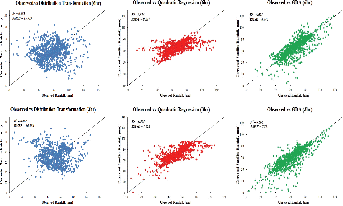
Correlation of the Merged Rainfall Products with the Observed Rainfall using Different Merging Techniques for Rainfall Interval of 6 and 3-hour
Table 2 depicts the performance statistics of each merging technique when correlating the merged products with the observed rainfall for different interval. The figures highlighted in bold indicates the optimal model for respective interval. GDA yielded highest R2 in each rainfall interval and lowest RMSE was also observed in durations of 6, 12, and 24-hour. However, quadratic regression yielded lower RMSE than GDA for duration of 1 and 3-hour. It has been observed in Baik et al. (2016) that GDA estimated more accurate rainfall in high rainfall amount. Lower rainfall amount was observed in duration of 1 and 3-hour and higher RMSE obtained in these durations further proven that performace of GDA may be impaired in low rainfall amount. In average, GDA was identified as the optimal model to yield most promising results as highest values of R2 (0.603) and lowest value of RMSE (8.150) were obtained. Thus, GDA will be adopted to merge the observed rainfall with the satellite rainfall products for ARF estimation in future study.

Results of Rainfall Clustering Analysis for Observed Rainfall Data and Satellite Rainfall Products
5. Conclusions
In conclusion, this study presented the feasibility of deriving ARF for storm design application in Malaysia using satellite rainfall products. Different spatial rainfall distributions have been observed from observed rainfall data and satellite rainfall products in which observed rainfall data showing localized characteristic while satellite rainfall products indicating homogeneous characteristic. Rainfall clustering analysis revealed that satellite rainfall products display stronger clustering effect than the observed rainfall as larger threshold radius and threshold area were obtained. Thus, merging of localized observed rainfall data with homogenous satellite rainfall products may improve ARF estimation for storm design application in the study area. Several satellite rainfall merging techniques have been evaluated in this study and it is recognized that the merged rainfall products obtained from GDA were closely related to the observed rainfall data. Distribution transformation computed the merged rainfall products in high dispersion and it failed to model the maximum rainfall amount as observed in the rainfall stations. Merged rainfall products obtained from quadratic regression portrayed moderate dispersion but it failed to model maximum rainfall amount as well. Thus, the merging technique of GDA will be adopted to merge the ground based observed rainfall with the satellite rainfall products for ARF estimation in future study and ARF estimated from using merged rainfall products will be compared with the one estimated from using ground based observed rainfall data only. An improved and precise empirical formula for ARF estimation will be derived for design storm applications in Malaysia.
Acknowledgement
This research was supported by a grant (17AWMP-B079625-04) from Water Management Research Program funded by Ministry of Land, Infrastructure and Transport of Korean government.