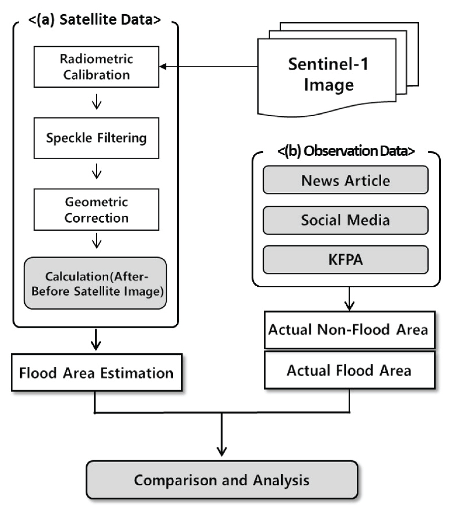
1. ņä£ ļĪĀ
ņĄ£ĻĘ╝ ĻĖ░Ēøäļ│ĆĒÖöļĪ£ ņØĖĒĢśņŚ¼ ņĀä ņäĖĻ│äņĀüņ£╝ļĪ£ Ļ░ĢņÜ░ņØś ņŗ£Ļ│ĄĻ░äņĀü ļČłĻĘĀĒśĢņØ┤ ņŗ¼ĒÖöļÉśĻ│Ā ņĀäļĪĆ ņŚåļŖö ĻĘ╣ĒĢ£ ņé¼ņāüņØ┤ ļ░£ņāØĒĢśĻ│Ā ņ׳ļŗż. ņØ┤ļ¤¼ĒĢ£ ņØ┤ņāüĻĖ░ĒøäļŖö ņ¦æņżæĒśĖņÜ░ ļ░Å Ēā£ĒÆŹņØś ĒśĢĒā£ļĪ£ ņ╣©ņłśņÖĆ Ļ░ÖņØĆ ļÅäņŗ£ņ×¼ļé£ņØś ļīĆĒśĢĒÖöŌŗģļ│ĄĒĢ®ĒÖöļź╝ ņĢ╝ĻĖ░ĒĢśļ»ĆļĪ£ ļÅäņŗ£ņ░©ņøÉņŚÉ ĻĘ╝ļ│ĖņĀüņØĖ ļīĆņØæņ▒ģ ļ¦łļĀ©ņØ┤ ĒĢäņłśņĀüņØ┤ļŗż.
ĻĖ░ņāüņ▓Ł ņŻ╝Ļ┤Ć 2018ļģä ņØ┤ņāüĻĖ░Ēøä ļ│┤Ļ│Āņä£(KMA, 2019)ņŚÉ ļö░ļź┤ļ®┤ ĻĄŁĒåĀĻĄÉĒåĄ ļČäņĢ╝ ņØ┤ņāüĻĖ░Ēøä ļīĆņØæ ļ░®ņĢłņ£╝ļĪ£ ŌĆśļÅäņŗ£ ĻĖ░Ēøäļ│ĆĒÖö ņ×¼ĒĢ┤ņĘ©ņĢĮņä▒ ļČäņäØ ļ░Å ĒÖ£ņÜ®ņŚÉ Ļ┤ĆĒĢ£ ņ¦Ćņ╣©ŌĆÖ Ļ░£ņĀĢ ņČöņ¦äņØä ĒåĄĒĢ┤ ņ×¼ĒĢ┤ņĘ©ņĢĮņä▒ ļČäņäØņØś ņĀüņÜ®ļīĆņāüņØä ĒÖĢļīĆĒĢśĻ│Ā ņ׳ļŗż. ņ¦Ćņ╣© ņāü ņ╣©ņłśņ¦ĆņŚŁņØś Ļ│ĄĻ░äņĀü ļ▓öņ£äĻ░Ć ĻĄ¼ņ▓┤ņĀüņØĖ Ļ▓ĮņÜ░ ļČäņäØ Ļ▓░Ļ│╝ļź╝ ĒåĀņ¦ĆņØ┤ņÜ®ļīĆņ▒ģ ļ¦łļĀ©ņŚÉ ņĀüĻĘ╣ ĒÖ£ņÜ®ĒĢĀ ņłś ņ׳ļŗżĻ│Ā ļ¬ģņŗ£ļÉśņ¢┤ ņ׳ņ£╝ļ»ĆļĪ£, ĻĄ¼ņ▓┤ņĀüņØ┤Ļ│Ā ņĀĢĒÖĢĒĢ£ ņ╣©ņłśņ¦ĆņŚŁņØä ĒīÉļ│äĒĢśņŚ¼ ņ╣©ņłśĒØöņĀüļÅäļź╝ ņ×æņä▒ĒĢśļŖö Ļ▓āņØ┤ ņżæņÜöĒĢśļŗż.
ĻĄŁļé┤ņŚÉņä£ļŖö ņ╣©ņłśĒØöņĀüļÅä ņ×æņä▒ņØä ņ£äĒĢ┤ ņ¦Ćņ×Éņ▓┤ņŚÉņä£ ņĪ░ņé¼ ņØĖļĀźņØä Ēö╝ĒĢ┤ņ¦ĆņŚŁņŚÉ ĒīīĻ▓¼ĒĢśņŚ¼ ĒśäņןņĪ░ņé¼ļź╝ ņłśĒ¢ēĒĢśĻ│Ā ņ׳ļŗż(Hwang et al., 2016). ĻĘĖļ¤¼ļéś ļÅÖņŗ£ļŗżļ░£ņĀüņ£╝ļĪ£ Ļ┤æļ▓öņ£äĒĢśĻ▓ī ļ░£ņāØĒĢśļŖö ņ╣©ņłśņŚÉ ļīĆĒĢ┤ņä£ ņĪ░ņé¼ļź╝ ļŗ┤ļŗ╣ĒĢĀ ņĀäļ¼Ė ņØĖļĀź ļ░Å ņśłņé░ņØ┤ ļČĆņĪ▒ĒĢ£ ņŗżņĀĢņØ┤ļ®░(Lee et al., 2006), Ēö╝ĒĢ┤ņĪ░ņé¼Ļ░Ć ļČĆņĀĢĒÖĢĒĢĀ Ļ░ĆļŖźņä▒ņØ┤ ņĪ┤ņ×¼ĒĢ£ļŗż(NIDP, 2008). ņØ┤ņÖĆ ļŹöļČłņ¢┤ ņ╣©ņłśĒØöņĀüļÅä ņ×ÉļŻīļŖö Ēö╝ĒĢ┤ņŚ░ļÅäņØś ņØ┤ļō¼ĒĢ┤ņŚÉ ņĀ£Ļ│ĄļÉśļ»ĆļĪ£ ņ╣©ņłśņ×ÉļŻīņØś ņ”ēĻ░üņĀüņØĖ ņĀæĻĘ╝ ļ░Å ņ░©Ēøä ļīĆņØæņØ┤ ļČłĻ░ĆĒĢśļŗż(Goo et al., 2011; Lim et al., 2016).
ņØĖĻ│Ąņ£äņä▒ņØä ĒÖ£ņÜ®ĒĢ£ ņøÉĻ▓®ĒāÉņé¼ ĻĖ░ļ▓ĢņØĆ Ļ┤æļ▓öņ£äĒĢśĻ│Ā ļŗżņ¢æĒĢ£ ņ×¼ļé£ņŚÉ ļīĆĒĢ£ ļČäņäØ ņ×ÉļŻīļź╝ ĒÜ©ņ£©ņĀüņØ┤Ļ│Ā ņĀĆļ╣äņÜ®ņ£╝ļĪ£ ņ¢╗ņØä ņłś ņ׳ĻĖ░ ļĢīļ¼ĖņŚÉ ņ╣©ņłśĒØöņĀüļÅä ņ×æņä▒ ĻĖ░ļ▓ĢņØś ļīĆņĢłņ£╝ļĪ£ ņĀ£ņŗ£ļÉśĻ│Ā ņ׳ļŗż(Notti et al., 2018). ĒÖŹņłśŌŗģņ╣©ņłś ļō▒ ņłśņ×¼ĒĢ┤ļŖö ņĢģņ▓£Ēøäļź╝ ļÅÖļ░śĒĢśĻĖ░ ļĢīļ¼ĖņŚÉ ņØĖĻ│Ąņ£äņä▒ ņ×ÉļŻī ņżæ ĻĖ░ņāüņØś ņśüĒ¢źņØä ņĀüĻ▓ī ļ░øļŖö ĒĢ®ņä▒Ļ░£ĻĄ¼ļĀłņØ┤ļŹö(Synthetic Aperture Radar; SAR)ņśüņāüņØś ĒÖ£ņÜ®ņä▒ņØ┤ ļåÆņĢäņ¦ĆĻ│Ā ņ׳ļŗż.
SAR ņ£äņä▒ņ×ÉļŻīļŖö ņØĖĻ│Ąņ£äņä▒ņŚÉņä£ ņ×Éņ▓┤ ļ░®ņČ£ĒĢ£ ļ¦łņØ┤Ēü¼ļĪ£ĒīīĻ░Ć ņØ┤ļ»Ėņ¦Ć Ēæ£ļ®┤ņŚÉņä£ ļ░śņé¼ļÉśņ¢┤ ļÅīņĢäņśżļŖö Ēøäļ░® ņé░ļ×Ć Ļ░Æ(backscatter)ņØä ĒåĄĒĢ┤ ņ×ÉļŻīĻ░Ć ņāØņä▒ļÉ£ļŗż. ņØ┤ļ¤¼ĒĢ£ ļ░śņé¼ ņŗĀĒśĖņŚÉ Ļ░ĢņĢĮņŚÉ ņśüĒ¢źņØä ļ»Ėņ╣śļŖö ņÜöņØĖņØĆ ļĀłņØ┤ļŹö ņ×ÉļŻī ĒŖ╣ņä▒(Ļ┤ĆņĖĪ ļ░®Ē¢ź, ņŻ╝Ēīīņłś, Ēīīņן ļō▒), ņØ┤ļ»Ėņ¦Ć Ēæ£ļ®┤ ĒŖ╣ņä▒(Ļ▒░ņ╣ĀĻĖ░, ņłśļČä ļō▒), ĒÖśĻ▓Į ļ░Å ĻĖ░ņāü ņÜöņØĖ(ņś©ļÅä, ļ╣ä, ļ░öļ×ī ļō▒)ņØ┤ ņ׳ļŗż. ĻĘĖņżæņŚÉņä£ SARņØś ļ¦łņØ┤Ēü¼ļĪ£Ēīī ņŗĀĒśĖļŖö Ēæ£ļ®┤ Ļ▒░ņ╣ĀĻĖ░ņŚÉ ļö░ļØ╝ ņ£Āņ×ģļÉśļŖö ļĀłņØ┤ļŹö Ēøäļ░® ņé░ļ×Ć Ļ░ÆņØ┤ Ēü¼Ļ▓ī ļ│ĆĒÖöĒĢśļŖöļŹ░, ĒŖ╣Ē׳ ņ¦ĆĒæ£ļ®┤Ļ│╝ ņłśĒæ£ļ®┤ņØś Ēøäļ░® ņé░ļ×Ć Ļ░ÆņØĆ Ēü░ ņ░©ņØ┤ļź╝ ļ│┤ņØĖļŗż. ņØ┤ļĢī, ņłśņ▓┤ņØś ļČĆļō£ļ¤¼ņÜ┤ Ēæ£ļ®┤ņØĆ ļĀłņØ┤ļŹöņØś ļ░śņé¼ļ®┤ņ£╝ļĪ£ ņ×æņÜ®ĒĢśņŚ¼ ļé«ņØĆ Ēøäļ░® ņé░ļ×Ć Ļ░ÆņØä Ļ░Ćņ¦Ćļ®░, ņ£äņä▒ ņśüņāüņŚÉņä£ Ļ▓ĆņØĆ ņāēņ£╝ļĪ£ Ēæ£ĒśäļÉśņ¢┤ ņ¦Ćļ®┤Ļ│╝ ĻĄ¼ļČäļÉ£ļŗż.
ņØ┤ļ¤¼ĒĢ£ SAR ņśüņāüņØś ĒŖ╣ņä▒ņØä ĒåĄĒĢśņŚ¼ ļŗżņ¢æĒĢ£ ņ╣©ņłś ņ¦ĆņŚŁ ĒīÉļ│ä ĻĖ░ļ▓ĢņØ┤ Ļ░£ļ░£ļÉśņŚłļŗż. ņ╣©ņłśņ¦ĆņŚŁĒīÉļ│ä ļ░®ļ▓Ģņ£╝ļĪ£ļŖö ļīĆĒæ£ņĀüņ£╝ļĪ£ ļŗ©ņł£ ņ£ĪņĢł ĒīÉļÅģ(Oberstadler et al., 1997), Ļ░ÉļÅģ ļČäļźś(Townsend, 2002), ļĀłņØ┤ļŹö Ēøäļ░® ņé░ļ×Ć Ļ░ÆņØś Ē׳ņŖżĒåĀĻĘĖļש ņ×äĻ│äĻ░Æ ņé░ņĀĢ(Schumann et al., 2014), ņŚ¼ļ¤¼ ņŗ£ņĀÉņØś ļŗżņżæ ņ£äņä▒ņśüņāü ņØ┤ļ»Ėņ¦ĆņØś ļ╣äĻĄÉ ļ░®ļ▓Ģ(Shin et al., 2012; Hwang et al., 2016) ļō▒ņØ┤ ņ׳ļŗż(Perrou et al., 2018).
SARļź╝ ĒÖ£ņÜ®ĒĢśņŚ¼ ņ╣©ņłś ņ¦ĆņŚŁņØä ļČäņäØĒĢ£ ĻĄŁļé┤ ņé¼ļĪĆļĪ£ļŖö Nam (2004)Ļ░Ć RADARSAT SAR ņśüņāüņØä ĒÖ£ņÜ®ĒĢśņŚ¼ ļéÖļÅÖĻ░Ģ ņ£ĀņŚŁņŚÉ ļ░£ņāØĒĢ£ ņ¦æņżæĒśĖņÜ░ļĪ£ ņØĖĒĢ£ ņ╣©ņłśņ¦ĆņŚŁņØä ļŗżņżæņŗ£ņĀÉ ņśüņāüņØä ļ╣äĻĄÉĒĢśņŚ¼ ņ╣©ņłśņ¦ĆņŚŁņØä ĻĄ¼ļČäĒĢśņśĆĻ│Ā, Landsat TM ņ×ÉļŻīļź╝ ņØ┤ņÜ®ĒĢśņŚ¼ ĒåĀņ¦Ć ņØ┤ņÜ®ļ│ä ņ╣©ņłśļ®┤ņĀüņØä Ļ│äņé░ĒĢśņśĆļŗż. Oh (2018)ņŚÉņä£ļŖö ļ»ĖĻĄŁ Ē£┤ņŖżĒä┤ ņ¦ĆņŚŁņŚÉ ĒŚłļ”¼ņ╝ĆņØĖ ĒĢśļ╣äļĪ£ ļ░£ņāØĒĢ£ ņ╣©ņłśļź╝ Sentinel-1ņÖĆ ņ×äĻ│äĻ░ÆņČöņČ£ļ░®ļ▓ĢņØä ĒåĄĒĢ┤ ļČäņäØĒĢśņśĆĻ│Ā, Ļ▓Ćņ”Ø ņ×ÉļŻīļĪ£ ļō£ļĪĀ ņ┤¼ņśü ņ×ÉļŻīļź╝ ĒÖ£ņÜ®ĒĢśņŚ¼ ĒåĀņ¦ĆņāüĒā£ņŚÉ ļö░ļźĖ ļČäņäØļ░®ļ▓ĢņØś ņĀĢĒÖĢļÅäļź╝ ņĀ£ņŗ£ĒĢśņśĆļŗż. Kim et al. (2007)ņŚÉņä£ļŖö RADARSAT SAR ņ×ÉļŻīļź╝ 1999ļģä ņéĮĻĄÉņ▓£ ņ£ĀņŚŁ ĒÖŹņłś ļČäņäØņŚÉ ņĀüņÜ®ĒĢśņśĆĻ│Ā, ņØ┤ Ļ▓░Ļ│╝ņÖĆ ņłśļ”¼ļČäņäØņŚÉ ņØśĒĢ£ Ļ▓░Ļ│╝ļź╝ ņ╣©ņłśņŗżņĀüļÅäņÖĆ ļ╣äĻĄÉĒĢśņŚ¼ SAR ņ╣©ņłśļČäņäØņ×ÉļŻīĻ░Ć ļé┤ņłśļ░░ņĀ£ ļČłļ¤ēņŚÉ ņØśĒĢ£ ņ╣©ņłśĻĄ¼ņŚŁ ņé░ņĀĢņŚÉ ļŹöņÜ▒ ĒÜ©ņ£©ņĀüņØ┤ļØ╝ļŖö Ļ▓░ļĪĀņØä ņ¢╗ņŚłļŗż.
ĻĄŁņÖĖ ņé¼ļĪĆļĪ£ļŖö Brivio et al. (2002)Ļ░Ć 1994ļģä ņØ┤Ēāłļ”¼ņĢä Tanaro Ļ░ĢņŚÉ ļ░£ņāØĒĢ£ ĒÖŹņłśļź╝ ERS SAR ņ£äņä▒ņśüņāüĻ│╝ ņ¦ĆĒśĢņ×ÉļŻīļź╝ ĒÖ£ņÜ®ĒĢśņŚ¼ ĒÖŹņłśļ▓öņ£äļź╝ ņČöņĀĢĒĢśņśĆĻ│Ā ņŗżņĖĪņ×ÉļŻīņÖĆ ļ╣äĻĄÉĻ▓░Ļ│╝ ļ®┤ņĀüņØś 96.7%Ļ░Ć ņØ╝ņ╣śĒĢśņśĆļŗż. Perrou et al. (2018)ļŖö Sentinel-1 A ņ×ÉļŻīņÖĆ ņ×äĻ│äĻ░Æ ļČäļźśļ▓Ģ ļ░Å ļŗżņżæņŗ£ņĀÉ ņśüņāü ļ╣äĻĄÉ ļ░®ļ▓ĢņØä ĒåĄĒĢ┤ 4Ļ░£ ĻĄŁĻ░Ć(ļČłĻ░Ćļ”¼ņĢä, ĻĘĖļ”¼ņŖż, ļ¦łņ╝ĆļÅäļŗłņĢä, ņäĖļź┤ļ╣äņĢä)ļź╝ ĒżĒĢ©ĒĢśļŖö Strymon/Struma ņ£ĀņŚŁņŚÉņä£ ņ╣©ņłśņ¦ĆņŚŁ ļČäņäØ ļ░Å ņ╣©ņłśļ░£ņāØņøÉņØĖņØä ĻĘ£ļ¬ģĒĢśņśĆļŗż. Notti et al. (2018)ņØĆ MODIS, Proba-V, Landsat, Sentinel-2, Sentinel-1Ļ│╝ Ļ░ÖņØĆ Ļ░£ļ░® ņ£äņä▒ ņ×ÉļŻīļź╝ ņØ┤ņÜ®ĒĢśņŚ¼ ņŖżĒÄśņØĖĻ│╝ ņØ┤Ēāłļ”¼ņĢäņŚÉņä£ ļ░£ņāØĒĢ£ ņ╣©ņłśņŚÉ ļīĆĒĢśņŚ¼ ĒīÉļ│äĒĢśņśĆņ£╝ļ®░, ņśüĒ¢źņÜöņØĖņØä ļČäņäØĒĢśņŚ¼ ņĀĢĒÖĢļÅä 5%ļČĆĒä░ 95%Ļ╣īņ¦Ć Ļ▓░Ļ│╝ļź╝ ļÅäņČ£Ē¢łļŗż.
ņ£äņÖĆ Ļ░ÖņØĆ ļČäņäØņØä ņĀüņÜ®ĒĢśĻĖ░ ņ£äĒĢ┤ņä£ 2017ļģä 9ņøö 11ņØ╝ ļ░£ņāØĒĢ£ ļČĆņé░ ņ¦ĆņŚŁ ņ¦æņżæĒśĖņÜ░Ōŗģņ╣©ņłś ņé¼ņāüņŚÉ ļīĆĒĢśņŚ¼ ļČäņäØņØä ņłśĒ¢ēĒĢśņśĆļŗż. ļČäņäØ ļ░®ļ▓Ģņ£╝ļĪ£ļŖö ņ╣©ņłś ņĀäĒøä ņŗ£ņĀÉ ņ£äņä▒ņśüņāü ļČäņäØ ļ░®ļ▓ĢņØä ņäĀĒāØĒĢśņśĆņ£╝ļ®░, ļČäņäØ ņ×ÉļŻīļĪ£ļŖö European Space Agency (ESA)ņØś Sentinel-1ņØä ņäĀĒāØĒĢśņśĆļŗż. ņØ┤ ĻĖ░Ļ░äņØś ņ╣©ņłśļŖö ļŗ©ĻĖ░Ļ░äņŚÉ ļÅÖņŗ£ļŗżļ░£ņĀüņ£╝ļĪ£ ļ░£ņāØĒĢśņŚ¼ ņ╣©ņłśĒØöņĀüļÅäĻ░Ć ņÖäļ▓ĮĒĢśĻ▓ī ĻĄ¼ņČĢļÉśņ¦Ć ņĢŖņĢä ĒĢ┤ļŗ╣ ĻĖ░Ļ░ä ļē┤ņŖż ĻĖ░ņé¼ņÖĆ ņåīņģ£ ļ»Ėļööņ¢┤ ļ░Å ĒÖöņ×¼ļ│┤ĒŚśĒśæĒÜī(Korean Fire Protection Association, KFPA) ņ×ÉļŻīļź╝ Ļ▓Ćņ”Øņ×ÉļŻīļĪ£ ĒÖ£ņÜ®ĒĢśņśĆĻ│Ā, ļ¦łņ¦Ćļ¦ēņ£╝ļĪ£ ņłśņŗĀņ×É ņĪ░ņ×æ ĒŖ╣ņä▒(Receiver Operating Characteristics, ROC) Ļ│ĪņäĀ ļČäņäØņØä ĒåĄĒĢ┤ ņ╣©ņłśņ×ÉļŻīņØś ņĀüņÜ®Ļ░ĆļŖźņä▒ņØä ĒÅēĻ░ĆĒĢśņśĆļŗż.
2. ņŚ░ĻĄ¼ ļ░®ļ▓Ģ
2.1 ņŚ░ĻĄ¼ļīĆņāüņ¦Ć
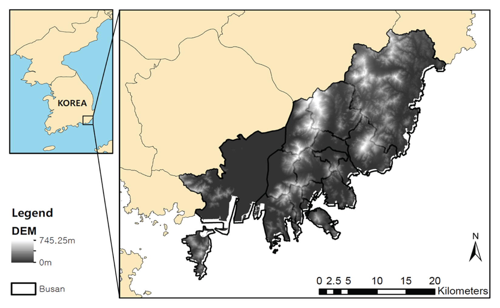
ļ│Ė ņŚ░ĻĄ¼ņØś ņŚ░ĻĄ¼ļīĆņāüņ¦ĆļŖö ļČĆņé░ ņ¦ĆņŚŁņ£╝ļĪ£ ņäżņĀĢĒĢśņśĆļŗż(Fig. 1). ļČĆņé░ņØĆ 30% ņØ┤ņāüņØś ļåÆņØĆ ļČłĒł¼ņłśļ®┤ņĀü ļ╣äņ£©(ME, 2013)Ļ│╝ Ļ▓Įņé¼Ļ░Ć ĻĖēĒĢ£ ņ¦ĆĒśĢņØ┤ ļ¦ÄņĢä ņ¦æņżæĒśĖņÜ░ ļ░£ņāØ ņŗ£ ņĀĆņ¦ĆļīĆ ņ╣©ņłśĻ░Ć ļ╣łļ▓łĒ׳ ņØ╝ņ¢┤ļé£ļŗż. ļČĆņé░ņØĆ 2017ļģä ĻĖ░ņżĆņ£╝ļĪ£ ņØ┤ņĀä 10ļģäĻ░ä ĒÆŹņłśĒĢ┤ņŚÉ ņØśĒĢ£ Ēö╝ĒĢ┤ņĢĪņØ┤ 1,740ņ¢ĄņøÉņ£╝ļĪ£ ņŻ╝ņÜöļÅäņŗ£ ņżæ ņĄ£ļīĆ Ēö╝ĒĢ┤ļź╝ ņ×ģņŚłņ£╝ļ®░, ĒÅēĻĘĀ 2ļģäņŚÉ ĒĢ£ ļ▓łņØś ļīĆĻĘ£ļ¬© ņ╣©ņłśļĪ£ ļ¦ēļīĆĒĢ£ Ļ▓ĮņĀ£ņĀüŌŗģņé¼ĒÜīņĀü Ēö╝ĒĢ┤ņŚÉ ļģĖņČ£ļÉśĻ│Ā ņ׳ļŗż(Kim, 2017).
ļČäņäØņØä ņĀüņÜ®ĒĢ£ ņ╣©ņłś ņé¼ņāüņØĆ 2017ļģä 9ņøö 11ņØ╝ņŚÉ ļČĆņé░ ņĀäņŚŁņŚÉ Ļ▒Ėņ╣£ ņ¦æņżæĒśĖņÜ░ļĪ£ ņØĖĒĢ£ ņ╣©ņłśņØ┤ļ®░, ņØ┤ ļĢī ļČĆņé░ Ļ┤ĆņĖĪņåī(Ļ┤ĆņĖĪņåīļ▓łĒśĖ: 159)ņŚÉņä£ļŖö ņØ╝Ļ░Ģņłśļ¤ē 264.1 mmļź╝ ĻĖ░ļĪØĒĢśņśĆļŗż. ņØ┤ļ┐Éļ¦ī ņĢäļŗłļØ╝ ļČĆņé░ņØś 15Ļ░£ Ļ┤ĆņĖĪņåī ņżæ 8Ļ░£ Ļ┤ĆņĖĪņåīņŚÉņä£ 100ļģä ļ╣łļÅä ņØ┤ņāüņØś Ļ░ĢņÜ░Ļ░ĢļÅäĻ░Ć ļ░£ņāØĒĢśņŚ¼(Kim, 2017), ņĢĮ 14ņ¢ĄņøÉņØś ņ┤Ø Ēö╝ĒĢ┤ņĢĪņØä ĻĖ░ļĪØĒĢśņśĆļŗż(MOIS, 2018).
2.2 ņ£äņä▒ņśüņāü DATA
ņ£äņä▒ņśüņāüņ£╝ļĪ£ļŖö ESAņŚÉņä£ ņĀ£Ļ│ĄĒĢśļŖö Sentinel-1 SARņ£äņä▒ņśüņāüņØä ņäĀĒāØĒĢśņśĆļŗż. Sentinel-1 ņ×ÉļŻīļŖö ESA ņø╣ņé¼ņØ┤ĒŖĖ(https://scihub.copernicus.eu/dhus/#/home)ņŚÉņä£ ļ¼┤ļŻīļĪ£ ņĀæĻĘ╝ĒĢĀ ņłś ņ׳ņ£╝ļ®░, ņ£äņä▒ņ×ÉļŻī ļČäņäØ ņåīĒöäĒŖĖņø©ņ¢┤(SNAP)ņÖĆ ToolboxļÅä ņĀ£Ļ│ĄĒĢśĻ│Ā ņ׳ļŗż. Sentinel-1ļŖö ņ£äņä▒ņŚÉņä£ ļ░®ņČ£ļÉ£ C-band ļĀłņØ┤ļŹö ņŗĀĒśĖĻ░Ć Ēæ£ļ®┤ņŚÉ ļ░śņé¼ļÉśņ¢┤ ļÅīņĢäņśżļŖö Ļ░ÆņØä ņĖĪņĀĢĒĢśļŖö active sensorļĪ£ ĻĄ¼ņä▒ļÉśņ¢┤ ņ׳ņ£╝ļ®░, ĻĖ░ņāü ņĪ░Ļ▒┤ņŚÉ Ļ┤ĆĻ│äņŚåņØ┤ ņśüņāüņØä ĻĄ¼ņä▒ĒĢĀ ņłś ņ׳ļŗż. ņŚ░ĻĄ¼ ļīĆņāü ņ╣©ņłś ņŗ£ņĀÉ ņĀäĒøäņØś Sentinel-1 ņśüņāüņØä ņłśņ¦æĒĢśņśĆņ£╝ļ®░(Fig. 2), ņśüņāüņØś ņĀ£ņøÉņØĆ Table 1ņŚÉ ĻĖ░ņłĀĒĢśņśĆļŗż.
2.3 ņ╣©ņłśņ¦ĆņŚŁ ņé░ņĀĢ ļ░®ļ▓Ģ
ļ│Ė ņŚ░ĻĄ¼ņØś ņ×ÉļŻīņ▓śļ”¼Ļ│╝ņĀĢņØĆ Fig. 3Ļ│╝ Ļ░Öļŗż. Ēü¼Ļ▓ī ņØĖĻ│Ąņ£äņä▒ ņśüņāüņ▓śļ”¼, ņ╣©ņłś ļ░Å ļ»Ėņ╣©ņłś Ļ┤ĆņĖĪ ņ×ÉļŻī ņłśņ¦æ ĻĘĖļ”¼Ļ│Ā ņĀüņÜ®ņä▒ ļČäņäØ Ļ│╝ņĀĢņ£╝ļĪ£ ĻĄ¼ņä▒ļÉśņ¢┤ņ׳ļŗż.
2.3.1 ņØĖĻ│Ąņ£äņä▒ ņśüņāüņ▓śļ”¼
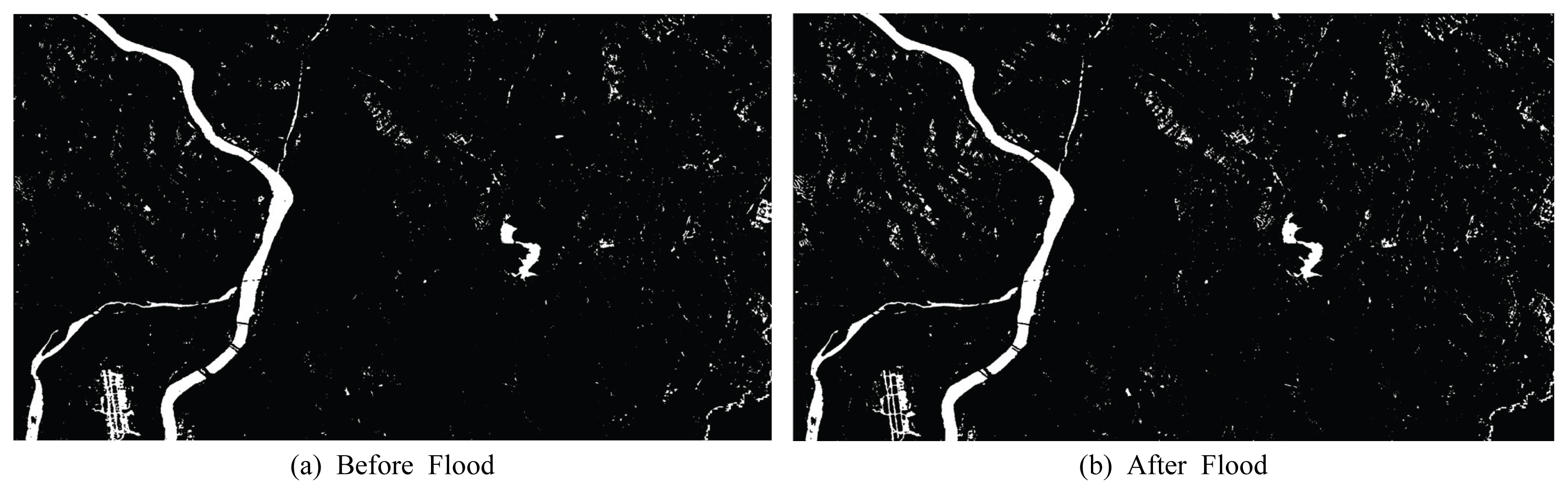
Fig. 3aņØĆ ņ£äņä▒ņ×ÉļŻī ņ▓śļ”¼Ļ│╝ņĀĢņØä ļéśĒāĆļéĖļŗż. Sentinel-1ņØĆ Ēøäļ░® ņé░ļ×Ć Ļ░Æņ£╝ļĪ£ ņśüņāüņØ┤ Ēæ£ņČ£ļÉśĻ│Ā, ņØ┤ņŚÉ ļö░ļØ╝ ņŖżĒÄśĒü┤ ļģĖņØ┤ņ”ł(Speckle Noise)ļź╝ ļÅÖļ░śĒĢ£ļŗż. ļśÉĒĢ£ ņ┤¼ņśü Ļ░üļÅäļĪ£ ņØĖĒĢ£ ņśżņ░©ļź╝ ļ│┤ņĀĢĒĢśļŖö ņ▓śļ”¼Ļ│╝ņĀĢņØä Ļ▒░ņ│ÉņĢ╝ĒĢ£ļŗż(Brivio et al., 2010). ņØ┤ņÖĆ Ļ░ÖņØĆ ņĀäņ▓śļ”¼ Ļ│╝ņĀĢņØĆ ESAņŚÉņä£ ņĀ£Ļ│ĄĒĢśļŖö ņ£äņä▒ņ×ÉļŻī ļČäņäØ ņåīĒöäĒŖĖņø©ņ¢┤ SNAPņØä ņØ┤ņÜ®ĒĢśņŚ¼ ņ▓śļ”¼ĒĢśņśĆļŗż.
Sentinel-1ņØś ņøÉņ×ÉļŻīļŖö ņ┤¼ņśüļ▓öņ£äĻ░Ć Ļ┤æļ▓öņ£äĒĢśņŚ¼ ņäĖļČĆņśüņŚŁņØä ņäżņĀĢĒĢśņŚ¼ ņČöņČ£ĒĢśņśĆļŗż. ĻĘĖļŗżņØī, ņśżņ░©Ļ░Ć ĒżĒĢ©ļÉ£ ņĀäņ×ÉĻĖ░Ēīīļź╝ ļ│┤ņĀĢĒĢśļŖö ļ░®ņé¼ļ│┤ņĀĢņØä ņłśĒ¢ēĒĢśĻ│Ā, ļģĖņØ┤ņ”łļź╝ ļ¦żļüäļ¤ĮĻ▓ī ņ▓śļ”¼ĒĢśļŖö ņŖżĒÄśĒü┤ ĒĢäĒä░ļ¦üņØä ņłśĒ¢ēĒĢśņśĆļŗż. ņŖżĒÄśĒü┤ ĒĢäĒä░ļŖö Gaussian ļČäĒżņŚÉ ļ¦×ņČöņ¢┤ ņłśņ╣śĻ░ÆņØä ĒÅēĻĘĀņ╣śļĪ£ ļ│┤ņĀĢĒĢśļŖö Lee sigma ĒĢäĒä░ļź╝ ņé¼ņÜ®ĒĢśņśĆļŗż(Lee, 1983). ņØ┤ļĢī, ĒÄĖĻ┤æ ņśĄņģśņ£╝ļĪ£ ņ╣©ņłśņ¦ĆņŚŁ ĒīÉļ│äņŚÉ ņÜ®ņØ┤ĒĢ£ VHļź╝ ņäĀĒāØĒĢśņśĆļŗż(Ezzine et al., 2018). ņĄ£ņóģņĀüņ£╝ļĪ£ ņ¦ĆĒśĢ ņÖ£Ļ│Ī ļ░Å ņ┤¼ņśü Ļ░üļÅäņŚÉ ļö░ļźĖ ņśżņ░©ļź╝ ļ│┤ņĀĢĒĢśļŖö ņ¦ĆĒśĢļ│┤ņĀĢņØä ņ¦äĒ¢ēĒĢśņśĆļŗż. ņĀäņ▓śļ”¼Ļ░Ć ņÖäļŻīļÉ£ ņśüņāüņØĆ ņ╣©ņłś ņĀäĻ│╝ ĒøäņØś ņ░©ņØ┤ļź╝ ĒåĄĒĢ┤ Ļ░ü Ļ▓®ņ×É Ļ░ÆņØ┤ -1ļČĆĒä░ 1ņé¼ņØ┤ Ļ░ÆņØä Ļ░Ćņ¦Ćļ®░, ĒĢ┤ļŗ╣ ļ▓öņ£ä ņé¼ņØ┤ņØś ņ×äĻ│äĻ░ÆņØä ņäżņĀĢĒĢśņŚ¼ ņ╣©ņłśĒīÉļ│äĻĖ░ņżĆņØä ņäĖņÜĖ ņłś ņ׳ļŗż. ņØ╝ļ░śņĀüņ£╝ļĪ£ ņĀäĒøä ņśüņāüņŚÉņä£ ņ¦ĆĒæ£ļ®┤ ĒŖ╣ņä▒ ļ│ĆĒÖöĻ░Ć ņŚåļŖö Ļ▓ĮņÜ░ 0ņŚÉ Ļ░ĆĻ╣īņÜ┤ Ļ░ÆņØä Ļ░Ćņ¦Ćļ®░, ņĀäĒøä ņśüņāüņŚÉņä£ ņ¦ĆĒæ£ļ®┤ņØ┤ ļ░śņé¼ ņŗĀĒśĖĻ░Ć Ēü░ ļ¦łļźĖ Ēæ£ļ®┤ņŚÉņä£ ļ░śņé¼ ņŗĀĒśĖĻ░Ć ņ×æņØĆ ņłśĒæ£ļ®┤ņ£╝ļĪ£ ņĀäĒÖśļÉĀ ņŗ£ 0 ņØ┤ņāüņØś Ļ░ÆņØä ļéśĒāĆļé┤Ļ▓ī ļÉ£ļŗż.
2.3.2 ņ╣©ņłś ļ░Å ļ»Ėņ╣©ņłś Ļ┤ĆņĖĪ ņ×ÉļŻī ņłśņ¦æ
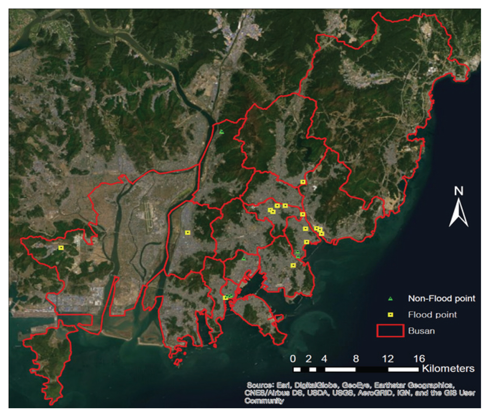
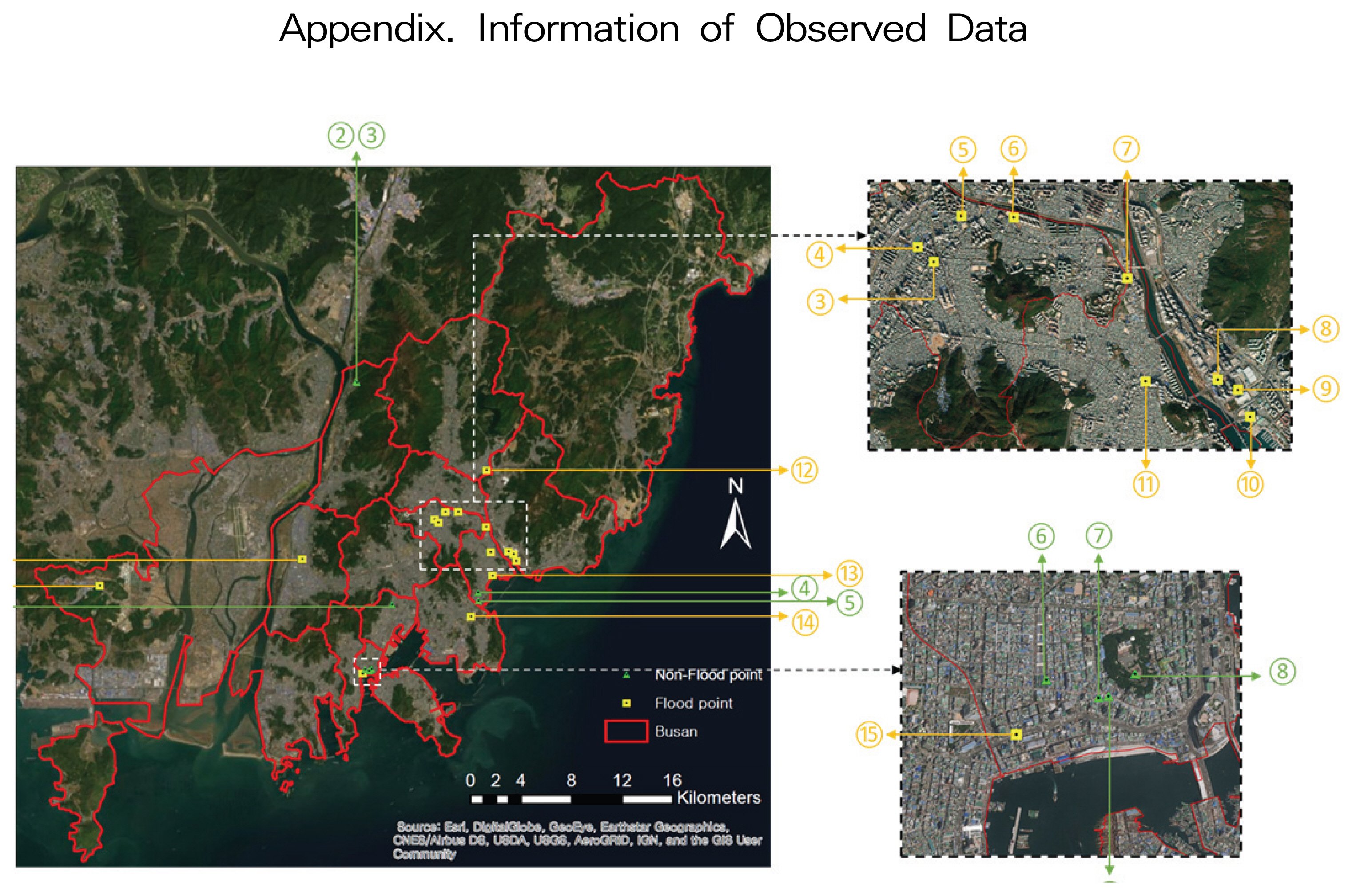
ļ©╝ņĀĆ ĒĢ┤ļŗ╣ ĻĖ░Ļ░äņŚÉ ļīĆĒĢ┤ņä£ ņ╣©ņłśĻ░Ć ļ░£ņāØĒĢ£ ĻĘĖļ”¼Ļ│Ā ļ░£ņāØĒĢśņ¦Ć ņĢŖņØĆ Ēśäņן ņé¼ņ¦ä ņ×ÉļŻīļź╝ Ļ░üĻ░ü ņ╣©ņłś ļ░Å ļ»Ėņ╣©ņłś Ļ┤ĆņĖĪ ņ×ÉļŻīļØ╝Ļ│Ā ņĀĢņØśĒĢśņśĆļŗż. SAR ņ£äņä▒ņśüņāüņØä ĒÖ£ņÜ®ĒĢ£ ņ╣©ņłśĒīÉļ│äĻĖ░ļ▓ĢņØś ņĀĢĒÖĢļÅä Ļ▓Ćņ”ØņØä ņ£äĒĢ┤ ņ╣©ņłś Ļ┤ĆņĖĪ ņ×ÉļŻīļź╝ ļē┤ņŖż ĻĖ░ņé¼ ļ░Å ĒÖöņ×¼ļ│┤ĒŚśĒśæĒÜīņØś ņé¼Ļ│ĀĒśäņן ņ×ÉļŻī(https://ucis.kfpa.or.kr/mapindex.do)ļź╝ ĒåĄĒĢ┤ ņłśņ¦æĒĢśņśĆļŗż. ĒĢ£ĒÄĖ, ROC Ļ│ĪņäĀņØä ĒåĄĒĢ┤ ĒīÉļ│äĻĖ░ļ▓ĢņØś ņĀüņÜ®ņä▒ņØä ĒīÉļŗ©ĒĢ©ņŚÉ ņ׳ņ¢┤ņä£ ņŗżņĀ£ ņ╣©ņłś ņ¦ĆņŚŁņØä ņØĖĻ│Ąņ£äņä▒ņØä ĒåĄĒĢ┤ ņ¢╝ļ¦łļéś ĒīÉļ│äĒĢ┤ļé╝ ņłś ņ׳ļŖöņ¦Ćļź╝ ļéśĒāĆļé┤ļŖö ņ▓ÖļÅäņØĖ ļ»╝Ļ░ÉļÅä(Sensitivity) ļ┐Éļ¦ī ņĢäļŗłļØ╝, ņŗżņĀ£ ņ╣©ņłśĻ░Ć ņØ╝ņ¢┤ļéśņ¦Ć ņĢŖņØĆ ņ¦ĆņŚŁņØä ņ╣©ņłśĻ░Ć ņØ╝ņ¢┤ļéśņ¦Ć ņĢŖņĢśļŗżĻ│Ā ĒīÉļ│äĒĢ┤ļé╝ ņłś ņ׳ļŖö ņ▓ÖļÅäņØĖ ĒŖ╣ņØ┤ļÅä(Specificity)ļź╝ Ļ│ĀļĀżĒĢ┤ņĢ╝ĒĢ£ļŗż. ĻĘĖ Ļ│╝ņĀĢ ņżæ Ļ░Ćņן ņżæņÜöĒĢ£ Ļ▓āņØĆ ļ»Ėņ╣©ņłś ņ¦ĆņŚŁņŚÉ ļīĆĒĢ£ Ļ┤ĆņĖĪ ņ×ÉļŻīņØś ņŗĀļó░ļÅäņØ┤ļ»ĆļĪ£ ļ│Ė ņŚ░ĻĄ¼ņŚÉņä£ļŖö ņ╣©ņłś ņŗĀĻ│Āļéś ņ╣©ņłś ņ×ÉļŻīĻ░Ć ņŚåļŖö Ļ││ņØä ļ»Ėņ╣©ņłś ņ¦ĆņŚŁņ£╝ļĪ£ Ļ░äņŻ╝ĒĢśņ¦Ć ņĢŖĻ│Ā, ņé¼ņ¦äņ£╝ļĪ£ ļ»Ėņ╣©ņłś ņ¦ĆņŚŁņØä ĒÖĢņØĖĒĢĀ ņłś ņ׳ļŖö ņ×ÉļŻīļź╝ ļē┤ņŖż ĻĖ░ņé¼ ļ░Å ņåīņģ£ ļ»Ėļööņ¢┤ļź╝ ĒåĄĒĢ┤ ņłśņ¦æĒĢśņśĆĻ│Ā, Ļ▓░Ļ│╝ ļČäņäØņŚÉ ĒÖ£ņÜ®ĒĢśņśĆļŗż. Fig. 4ņŚÉņä£ ļģĖļ×Ćņāē ņĀÉņØĆ ņ╣©ņłś ļ░£ņāØ ņ¦ĆņĀÉ, ņ┤łļĪØņāē ņĀÉņØĆ ļ»Ėņ╣©ņłś ņ¦ĆņĀÉņØä ļéśĒāĆļé┤ļ®░ Ļ░ü Ļ░ü 15Ļ░£, 9Ļ░£ļĪ£ ĻĄ¼ņä▒ļÉśņŚłļŗż. ņ¦ĆņĀÉņŚÉ ļīĆĒĢ£ ņ×ÉņäĖĒĢ£ ņ£äņ╣śĻĄ¼ļČä ļ░Å ņČ£ņ▓śļŖö AppendixņŚÉ ņłśļĪØĒĢśņśĆļŗż.
2.3.3 ņĀüņÜ®ņä▒ ļČäņäØ
Sentinel-1 ĻĖ░ļ░ś ņ╣©ņłśĒīÉļ│äĻĖ░ļ▓ĢņØś ņĀüņÜ®ņä▒ņØä ĒÅēĻ░ĆĒĢśĻĖ░ ņ£äĒĢ┤ ROC Ļ│ĪņäĀ ļČäņäØņØä ņłśĒ¢ēĒĢśņśĆļŗż. ROC Ļ│ĪņäĀ ļČäņäØņŚÉņä£ļŖö ļ©╝ņĀĆ ņé¼ņāüņØ┤ ņśżņ¦ü 2Ļ░Ćņ¦Ć(ņ╣©ņłś, ļ»Ėņ╣©ņłś)ļĪ£ ļČäļźśļÉśļŖö ļ¼ĖņĀ£ņŚÉ ņĀüņÜ®ļÉĀ ņłś ņ׳ņ£╝ļ®░, ļ░śļō£ņŗ£ ņŗĀļó░ĒĢĀ ņłś ņ׳ļŖö ņŗżņĀ£ Ļ▓░Ļ│╝Ļ░Ć ĒĢäņÜöĒĢśļŗż. ļČäļźś ĻĖ░ņżĆ ļ¬©ĒśĢ(Sentinel-1 ĻĖ░ļ░ś ņ╣©ņłśĒīÉļ│äĻĖ░ļ▓Ģ)ņŚÉ ļö░ļØ╝ Table 2ņÖĆ Ļ░ÖņØ┤ ņśżņ░©Ē¢ēļĀ¼(Confusion matrix)ņØä ņ×æņä▒ĒĢĀ ņłś ņ׳ņ£╝ļ®░, ņØ┤ļŖö ņŗżņĀ£ Ļ│äņĖĄĻ│╝ ņśłņĖĪ Ļ│äņĖĄņ£╝ļĪ£ ļéśļłäņ¢┤ņĀĖ ļæÉ Ļ│äņĖĄņØś ņ░©ņØ┤ļź╝ Ēæ£ĒśäĒĢ£ļŗż. Positiveļź╝ 1, Negativeļź╝ 0ņ£╝ļĪ£ ņäżņĀĢĒ¢łņØä ļĢī ņŗżņĀ£ 1ņØś Ļ░ÆņØä Ļ░Ćņ¦ĆļŖö ļŹ░ņØ┤Ēä░ņŚÉ ļīĆĒĢ┤ ļČäļźś ļ¬©ļŹĖņØ┤ 1ļĪ£ ļČäļźśĒĢ£ ļ╣äņ£©ņØä TP, 0ņ£╝ļĪ£ ņלļ¬╗ ļČäļźśĒĢ£ ļ╣äņ£©ņØä FNļØ╝Ļ│Ā ĒĢśļ®░, ņŗżņĀ£ 0ņØś Ļ░ÆņØä Ļ░Ćņ¦ĆļŖö ļŹ░ņØ┤Ēä░ņŚÉ ļīĆĒĢ┤ 0ņ£╝ļĪ£ ņĀĢĒÖĢĒ׳ ļČäļźśĒĢ£ ļ╣äņ£©ņØä TN, 1ļĪ£ ņלļ¬╗ ļČäļźśĒĢ£ ļ╣äņ£©ņØä FPļØ╝Ļ│Ā ĒĢ£ļŗż.
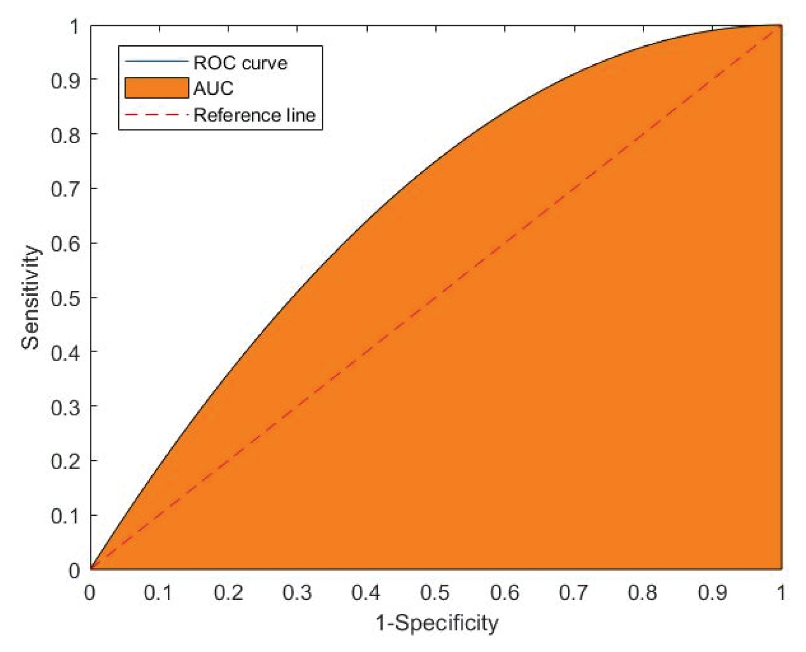
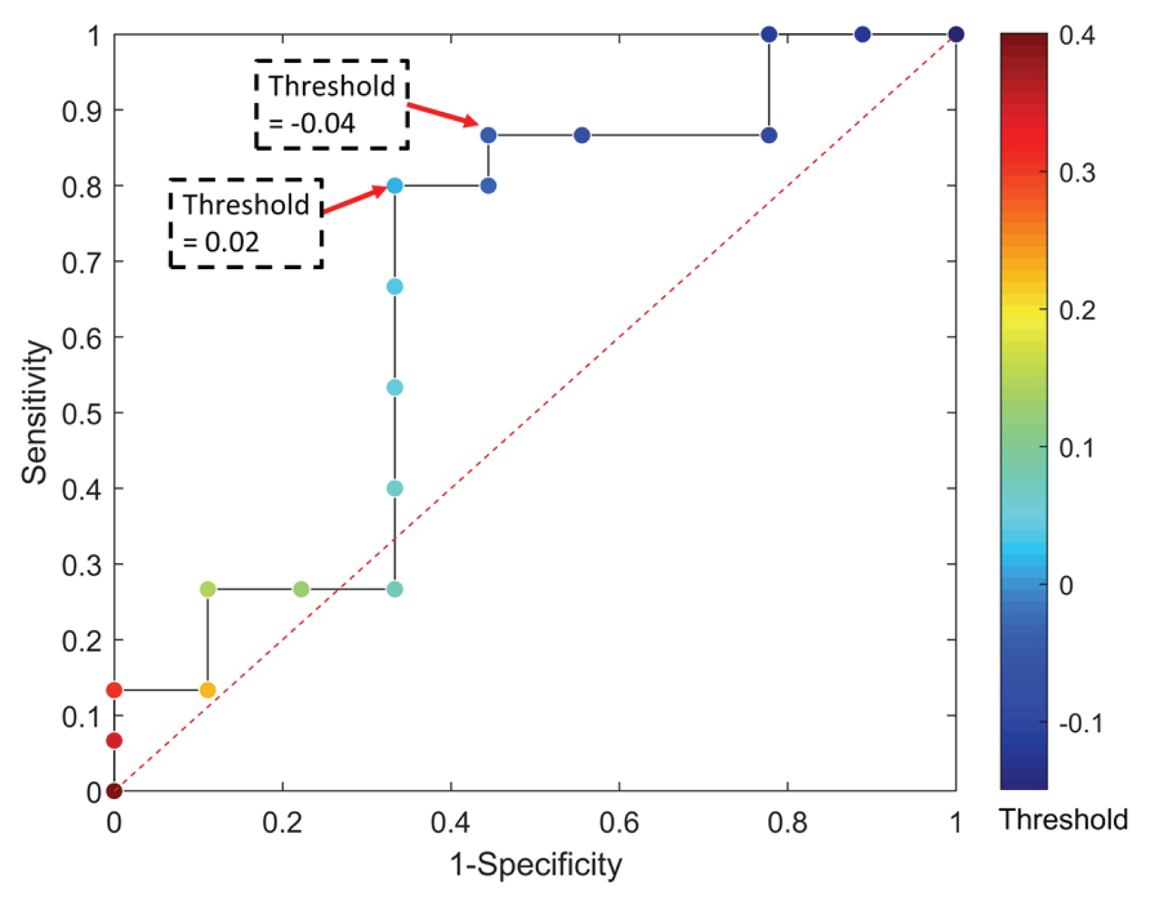
ļČäļźś ļ¬©ĒśĢņØś ņĀüņÜ®ņä▒ņØä ļČäņäØņŗ£ Ļ│ĀļĀżĒĢ┤ņĢ╝ĒĢĀ ļæÉ Ļ░Ćņ¦Ć ĒĢŁļ¬®ņØĆ ņŗżņĀ£ 1ņØś Ļ░ÆņØä Ļ░¢ļŖö ļŹ░ņØ┤Ēä░ļź╝ 1ļĪ£ ļČäļźśĒĢśļŖö ļ╣äņ£©ņØĖ ļ»╝Ļ░ÉļÅä(Sensitivity)ņÖĆ ņŗżņĀ£ 0ņØś Ļ░ÆņØä Ļ░¢ļŖö ļŹ░ņØ┤Ēä░ļź╝ 0ņ£╝ļĪ£ ļČäļźśĒĢśļŖö ļ╣äņ£©ņØĖ ĒŖ╣ņØ┤ļÅä(Specificity)ņØ┤ļŗż. ļ»╝Ļ░ÉļÅäļŖö TP/(TP+FN)ļĪ£ Ēæ£ĒśäļÉśļ®░, ĒŖ╣ņØ┤ļÅäļŖö TN/(FP+TN)ņ£╝ļĪ£ Ēæ£ĒśäļÉ£ļŗż. ļ¼┤ņ×æņ£ä ļČäļźś ļ¬©ĒśĢņŚÉņä£ļŖö ņØ┤ ļæÉ ņłśņ╣śĻ░Ć ļ░śļ╣äļĪĆĒĢśļŖö Ļ▓ĮĒ¢źņØ┤ ņ׳ņ£╝ļ»ĆļĪ£, ņØ┤ļź╝ ļ¬©ļæÉ Ļ│ĀļĀżĒĢ£ ļČäļźś ļ¬©ĒśĢ ĒÅēĻ░Ć ņ¦ĆĒæ£ļź╝ ĒÖ£ņÜ®ĒĢ┤ņĢ╝ĒĢ£ļŗż. ņØ┤ļź╝ ņ£äĒĢ┤ ROC Ļ│ĪņäĀņØ┤ Fig. 5ņÖĆ Ļ░ÖņØ┤ ņĀ£ņŗ£ļÉśņŚłļŗż. ROC Ļ│ĪņäĀņØś xņČĢņØĆ ĒŖ╣ņØ┤ļÅäņØś ļ░śļīĆĻ░ÆņØĖ ŌĆś1-ĒŖ╣ņØ┤ļÅäŌĆÖ, yņČĢņØĆ ŌĆśļ»╝Ļ░ÉļÅäŌĆÖļĪ£ ņØ┤ļŻ©ņ¢┤ņĀĖ ņ׳ņ£╝ļ®░, ļ¬©ĒśĢ ĒÅēĻ░Ć ņ¦ĆĒæ£ļŖö ROC Ļ│ĪņäĀņØś ļ░æļ®┤ņĀü(Area Under the ROC Curve; AUC)ņØ┤ļŗż. Fig. 5ņØś ņĀÉņäĀņ£╝ļĪ£ ļéśĒāĆļéĖ ņ░ĖņĪ░ ņäĀņØĆ ļ¼┤ņ×æņ£ä ļČäļźś ļ¬©ĒśĢņ£╝ļĪ£ ņØ┤ ņ¦üņäĀņØś AUCņØĖ 0.5ļ│┤ļŗż Ēü░ Ļ░Æ, ņ”ē ņ£äļĪ£ ļŹöņÜ▒ ļ¦ÄņØ┤ ļ¢©ņ¢┤ņ¦ä Ļ│ĪņäĀņØä ļéśĒāĆļé╝ņłśļĪØ ĒÜ©ņ£©ņĀüņØĖ ļ¬©ĒśĢņ£╝ļĪ£ ĒÅēĻ░ĆļÉ£ļŗż. ļ│Ė ņŚ░ĻĄ¼ņŚÉņä£ļŖö ņ▓śļ”¼ļÉ£ SAR ņśüņāüņŚÉņä£ ņ×äĻ│äĻ░ÆņØä -1ļČĆĒä░ 1Ļ╣īņ¦Ć 0.1ņö® ņ”ØĻ░Ćņŗ£Ēéżļ®░ ĻĘĖ ļĢī ņé░ņĀĢļÉ£ ĒŖ╣ņØ┤ļÅäņÖĆ ļ»╝Ļ░ÉļÅäņŚÉ ļö░ļØ╝ ROC Ļ│ĪņäĀņØä ļÅäņČ£ĒĢśņśĆļŗż.
3. ņŚ░ĻĄ¼ Ļ▓░Ļ│╝
3.1 ROC Ļ│ĪņäĀ ļČäņäØ
SAR ņ£äņä▒ņśüņāüņØä ĒåĄĒĢ£ ņ╣©ņłśĒīÉļ│äĻĖ░ļ▓ĢņØś ņĀüņÜ®ņä▒ņØä ĒīÉļŗ©ĒĢśĻĖ░ ņ£äĒĢ┤ ROC Ļ│ĪņäĀ ļČäņäØņØä ņŗżņŗ£ĒĢśņśĆļŗż. ņŚ¼ĻĖ░ņä£ ŌĆśņ╣©ņłśŌĆÖļź╝ Positive, ŌĆśļ»Ėņ╣©ņłśŌĆÖļź╝ NegativeļĪ£ ņäżņĀĢĒĢśņŚ¼ ļČäņäØĒĢśņśĆņ£╝ļ»ĆļĪ£ ļ»╝Ļ░ÉļÅäļŖö ņŗżņĀ£ ņ╣©ņłś ņ¦ĆņŚŁņØä ļČäņäØ ĻĖ░ļ▓ĢņØä ĒåĄĒĢ┤ ņ╣©ņłś ņ¦ĆņŚŁņ£╝ļĪ£ ņל ļČäļźśĒĢ┤ļé┤ļŖö ņ¦ĆĒæ£ņØ┤Ļ│Ā, ĒŖ╣ņØ┤ļÅäļŖö ņŗżņĀ£ ļ»Ėņ╣©ņłś ņ¦ĆņŚŁņØä ņĀ£ļīĆļĪ£ ļČäļźśĒĢ┤ļé┤ļŖö ņ¦ĆĒæ£ļØ╝Ļ│Ā ĒĢĀ ņłś ņ׳ļŗż. ņŗżņĀ£ ņ╣©ņłś ņ¦ĆņŚŁ 15Ļ░£ ņ¦ĆņĀÉ, ļ»Ėņ╣©ņłś ņ¦ĆņŚŁ 9Ļ░£ ņ¦ĆņĀÉņØä ļīĆņāüņ£╝ļĪ£ ņ×äĻ│äĻ░ÆņØä -1ļČĆĒä░ 1Ļ╣īņ¦Ć ļ│ĆĒÖöņŗ£Ēéżļ®░ ņ╣©ņłś, ļ»Ėņ╣©ņłśļź╝ ĒīÉļ│äĒĢśņśĆņ£╝ļ®░, ĻĘĖ Ļ▓░Ļ│╝ ROC Ļ│ĪņäĀņØĆ Fig. 6Ļ│╝ Ļ░Öļŗż. Fig. 6ņŚÉņä£ Ļ░ü ņĀÉļōżņØĆ ņ×äĻ│äĻ░ÆņØ┤ ļ│ĆĒĢ©ņŚÉ ļö░ļØ╝ ļ»╝Ļ░ÉļÅäļéś ĒŖ╣ņØ┤ļÅäĻ░Ć ļ│ĆĒĢśļŖö ņ¦ĆņĀÉņØä ļéśĒāĆļé┤ļ®░, ĻĘĖ ļĢīņØś ņ×äĻ│äĻ░ÆņØä ņāēņāüņ£╝ļĪ£ ļéśĒāĆļé┤ņŚłļŗż. ĻĘĖļ”╝ņØś ņ╗¼ļ¤¼ļ░öļŖö ņ£ĀĒÜ©ĒĢ£ ņ×äĻ│äĻ░Æ ļ▓öņ£äļĪ£ ņČĢņåīĒĢśņŚ¼ ļīĆļ╣äņŗ£ņ╝░ļŗż.
ļ©╝ņĀĆ AUC Ļ░ÆņØĆ 0.67ļĪ£ ļéśĒāĆļéś ņĀäļ░śņĀüņ£╝ļĪ£ ĒÜ©ņ£©ņĀüņØĖ ĒīÉļ│äĻĖ░ļ▓Ģņ£╝ļĪ£ ĒīÉļŗ©ĒĢĀ ņłś ņ׳ļŗż. ĻĘĖļ¤¼ļéś reference lineļ│┤ļŗż ņĢäļלņŚÉ ņ░ŹĒ×ī ņĀÉņŚÉņä£ ļ│╝ ņłś ņ׳ļō»ņØ┤ ņ×äĻ│äĻ░Æ ņäżņĀĢņŚÉ ļö░ļØ╝ ļ¼┤ņ×æņ£ä ļ¬©ĒśĢļ│┤ļŗż ņ╣©ņłś ĒīÉļ│ä ĒÜ©ņ£©ņØ┤ ļŹö ļé«ņĢäņ¦ł ņłś ņ׳ļŗż. ļö░ļØ╝ņä£ ņ×äĻ│äĻ░ÆņØä ņל ņäĀĒāØĒĢśļŖö Ļ▓āņØ┤ ņżæņÜöĒĢśļ®░, ņé¼ņÜ®ņ×ÉņØś ļ¬®ņĀüņŚÉ ļö░ļØ╝ ļ»╝Ļ░ÉļÅä ļśÉļŖö ĒŖ╣ņØ┤ļÅäļź╝ ņ”ØĻ░Ćņŗ£ĒéżļŖö ņ×äĻ│äĻ░ÆņØä ņäĀĒāØĒĢĀ ņłś ņ׳ļŗż. ļ»╝Ļ░ÉļÅäņÖĆ ĒŖ╣ņØ┤ļÅäļŖö ļ░śļ╣äļĪĆĒĢĀ ņłś ņ׳ņ¦Ćļ¦ī ņ£ä Ļ▓░Ļ│╝ņŚÉņä£ļŖö ĒŖ╣Ē׳ ņ×äĻ│äĻ░Æ -0.04ņØ┤ĒĢś 0.02ņØ┤ņāüņØś ļ▓öņ£äņŚÉņä£ļŖö ļ»╝Ļ░ÉļÅäņÖĆ ĒŖ╣ņØ┤ļÅäĻ░Ć Ļ░ü Ļ░ü ņāüļīĆ ņ¦ĆĒæ£ņØś ņ”ØĻ░Ćļ¤ēņŚÉ ļ╣äĒĢ┤ Ēü░ ĒÅŁņ£╝ļĪ£ Ļ░ÉņåīĒĢśļŖö Ļ▓āņØä ĒÖĢņØĖĒĢĀ ņłś ņ׳ņŚłļŗż. ļ│Ė ņŚ░ĻĄ¼ņŚÉņä£ļŖö ļ│┤ņłśņĀüņØĖ Ļ┤ĆņĀÉņ£╝ļĪ£ ņ×äĻ│äĻ░ÆņØä ņäĀņĀĢĒĢśņŚ¼ ņĢĮ 80%ņØś ļ»╝Ļ░ÉļÅäļź╝ Ļ░Ćņ¦ĆļŖö ņ×äĻ│äĻ░Æ 0.02ļĪ£ ņŗżņĀ£ ņ╣©ņłś ņ¦ĆņŚŁ ļīĆņāü ņ╣©ņłś ņ¦ĆļÅäļź╝ ņ×æņä▒ĒĢśņŚ¼ Ļ┤ĆņĖĪ ņ×ÉļŻīņÖĆ ļ╣äĻĄÉĒĢśņśĆļŗż.
3.2 ņ╣©ņłś ĻĄ¼ņŚŁ ļ╣äĻĄÉ
ņ╣©ņłś Ļ┤ĆņĖĪ ņ×ÉļŻīļĪ£ ĒÖ£ņÜ®ĒĢ£ Ēśäņן ņé¼ņ¦äņØĆ ņ╣©ņłś ņ¦ĆņŚŁ ņżæ ņØ╝ļČĆļČäļ¦ī ņĢī ņłś ņ׳ĻĖ░ ļĢīļ¼ĖņŚÉ ņ╣©ņłś ļ®┤ņĀüņØ┤ļéś ņ╣©ņłśņŗ¼ ļ╣äĻĄÉņÖĆ Ļ░ÖņØĆ ņĀĢļ¤ēņĀü ļČäņäØņŚÉļŖö ĒĢ£Ļ│äĻ░Ć ņ׳ļŗż. ļö░ļØ╝ņä£ ļ│Ė ņŚ░ĻĄ¼ņŚÉņä£ļŖö ņĀĢņä▒ņĀü ļČäņäØņŚÉ ņ┤łņĀÉņØä ļ¦×ņČöĻ│Ā, ņČöĒøä ĒøäņåŹ ņŚ░ĻĄ¼ņŚÉņä£ ņ╣©ņłś ņ¦ĆņŚŁ ļ░Å ļ®┤ņĀüņØ┤ ņ╣©ņłśĒØöņĀüļÅäņŚÉ ņĀĢļ░ĆĒĢśĻ▓ī ĻĄ¼ņČĢļÉ£ ņé¼ņāüņŚÉ ļīĆĒĢśņŚ¼ ņČöĻ░ĆņĀüņ£╝ļĪ£ ļČäņäØĒĢ┤ļ│╝ ņłś ņ׳ņØä Ļ▓āņØ┤ļŗż.
Fig. 7ņØĆ ņ╣©ņłś ļ░£ņāØ ņ¦ĆņĀÉ 15Ļ░£ ņ¦ĆņĀÉņŚÉņä£ ļ╣äĻĄÉņĀü Ļ┤ĆņĖĪ ņ×ÉļŻīņØś Ļ│ĄĻ░äņĀü ļ▓öņ£äĻ░Ć ļäōĻ▓ī ņ┤¼ņśüļÉ£ 4Ļ░£ ņ¦ĆņĀÉņØä ņäĀņĀĢĒĢśņŚ¼ Ļ┤ĆņĖĪ ņ×ÉļŻīņÖĆ ņŚ░ĻĄ¼ ļČäņäØ Ļ▓░Ļ│╝ļź╝ ļ╣äĻĄÉĒĢ£ ĻĘĖļ”╝ņØ┤ļŗż. ņ×äĻ│äĻ░ÆņØä ļ│┤ņłśņĀüņ£╝ļĪ£ ņäĀņĀĢĒĢ£ ļ¦īĒü╝ ņ╣©ņłś ņ¦ĆņŚŁņØ┤ ņŗżņĀ£ļ│┤ļŗż ļŗżņåī Ļ│╝ļīĆ ņé░ņĀĢļÉśļŖö Ļ▓ĮĒ¢źņØä ļ│┤ņśĆņ£╝ļéś 4ņ¦ĆņĀÉ ļ¬©ļæÉ Ļ┤ĆņĖĪ ņ×ÉļŻīņŚÉņä£ ļ│┤ņØ┤ļŖö ņ╣©ņłśņ¦ĆņŚŁņØä ļīĆļČĆļČä ĒżĒĢ©ĒĢśļŖö Ļ▓░Ļ│╝ļź╝ ļéśĒāĆļāłļŗż. ļśÉĒĢ£ ņŻ╝ļ│ĆņŚÉ ļåÆņØĆ Ļ▒┤ļ¼╝ņØ┤ ņ£äņ╣śĒĢ£ Figs. 7(c), (d)ņŚÉņä£ ņśżņ░©Ļ░Ć ņāüļīĆņĀüņ£╝ļĪ£ Ēü¼Ļ▓ī ļéśĒāĆļéśļŖöļŹ░, ņØ┤ļŖö ņןņĢĀļ¼╝ņŚÉ ņØśĒĢ┤ ļ░śņé¼ļÉśņ¢┤ SARņØś ņŗĀĒśĖĻ░Ć Ļ│╝ļīĆ ņČöņĀĢļÉ£ Ļ▓āņ£╝ļĪ£ ĒĢ┤ņäØļÉ£ļŗż. ņØ┤ļź╝ ĒåĄĒĢ┤ ROC Ļ│ĪņäĀ ļČäņäØ Ļ▓░Ļ│╝ļĪ£ ĒĢ┤ļŗ╣ ņ¦ĆņĀÉ Ļ▓®ņ×É ņ╣©ņłśņŚ¼ļČĆļź╝ ĒīÉļ│äĒĢśĻ│Ā, ļČäņäØļ¬®ņĀüņŚÉ ņĄ£ņĀüņØĖ ņ×äĻ│äĻ░ÆņØä ņé░ņĀĢĒĢśņŚ¼ ņ╣©ņłś ņ¦ĆņŚŁņØä ņČöņĀĢĒĢĀ ņłś ņ׳ļŗżļŖö Ļ▓░Ļ│╝ļź╝ ņ¢╗ņŚłļŗż.
4. Ļ▓░ ļĪĀ
ļ│Ė ņŚ░ĻĄ¼ņŚÉņä£ļŖö ĻĖ░ņāü ņĪ░Ļ▒┤ņŚÉ ņØśĒĢ£ ņśüĒ¢źņØ┤ ņāüļīĆņĀüņ£╝ļĪ£ ņĀüņØĆ SAR ņ£äņä▒ņśüņāüņØä ĒÖ£ņÜ®ĒĢśņŚ¼ ņ╣©ņłśļź╝ ĒīÉļ│äĒĢśĻ│Ā, ĒīÉļ│äĻĖ░ļ▓ĢņØś ņĀüņÜ®ņä▒ņØä ļČäņäØĒĢśĻ│Āņ×ÉĒĢśņśĆļŗż. ņØ┤ļź╝ ņ£äĒĢ┤ 2017ļģä 9ņøö 11ņØ╝ ļ░£ņāØĒĢ£ ļČĆņé░ ņ¦ĆņŚŁ ņ¦æņżæĒśĖņÜ░Ōŗģņ╣©ņłś ņé¼ņāüņØä ļīĆņāüņ£╝ļĪ£ ņäĀņĀĢĒĢśņŚ¼ ņłśĒ¢ēĒĢśņśĆļŗż. ņØĖĻ│Ąņ£äņä▒ņśüņāü ĻĖ░ļ░ś ņ╣©ņłśĒīÉļ│äĻĖ░ļ▓Ģņ£╝ļĪ£ļŖö ņ╣©ņłś ņĀäĒøä ņŗ£ņĀÉņØś ņ£äņä▒ņśüņāü ņØ┤ļ»Ėņ¦Ćļź╝ ļČäņäØ ļ░®ļ▓ĢņØä ņäĀĒāØĒĢśņśĆņ£╝ļ®░, ļČäņäØ ļīĆņāü ņ×ÉļŻīļĪ£ļŖö European Space Agency (ESA)ņØś Sentinel-1ļĪ£ ņäżņĀĢĒĢśņśĆļŗż. ņØ┤ ĻĖ░Ļ░äņØś ņ╣©ņłśļŖö ļŗ©ĻĖ░Ļ░äņŚÉ ļÅÖņŗ£ļŗżļ░£ņĀüņ£╝ļĪ£ ļ░£ņāØĒĢśņŚ¼ ņ╣©ņłśĒØöņĀüļÅäĻ░Ć ņÖäļ▓ĮĒĢśĻ▓ī ĻĄ¼ņČĢļÉśņ¦Ć ņĢŖņĢä ĒĢ┤ļŗ╣ ĻĖ░Ļ░ä ļē┤ņŖż ĻĖ░ņé¼ņÖĆ ņåīņģ£ ļ»Ėļööņ¢┤ ļ░Å ĒÖöņ×¼ļ│┤ĒŚśĒśæĒÜī(Korean Fire Protection Association, KFPA) ņ×ÉļŻīļź╝ Ļ▓Ćņ”Øņ×ÉļŻīļĪ£ ĒÖ£ņÜ®ĒĢśņśĆļŗż. ĒŖ╣Ē׳ ņ╣©ņłś ņ¦ĆņŚŁļ┐Éļ¦ī ņĢäļŗłļØ╝ ņ╣©ņłśĻ░Ć ņØ╝ņ¢┤ļéśņ¦Ć ņĢŖņØĆ ļ»Ėņ╣©ņłś ņ¦ĆņŚŁņŚÉ ļīĆĒĢ£ Ļ┤ĆņĖĪ ņ×ÉļŻīļź╝ ņłśņ¦æĒĢśņŚ¼ ļČäņäØņŚÉ ĒÖ£ņÜ®ĒĢśņśĆļŗż.
ļ©╝ņĀĆ ņ╣©ņłśĒīÉļ│äĻĖ░ļ▓ĢņŚÉ ļīĆĒĢ£ ROC Ļ│ĪņäĀ ļČäņäØ Ļ▓░Ļ│╝ AUCļŖö 0.67ņ£╝ļĪ£ ņĀäļ░śņĀüņ£╝ļĪ£ ĒÜ©ņ£©ņĀüņØĖ ņä▒ļŖźņØä ļéśĒāĆļāłņ£╝ļéś, ņ×äĻ│äĻ░Æ ņäĀĒāØņŚÉ ļö░ļØ╝ ļ¼┤ņ×æņ£ä ļ¬©ĒśĢļ│┤ļŗż ļ╣äĒÜ©ņ£©ņĀüņØĖ Ļ▓░Ļ│╝Ļ░Ć ļéśĒāĆļéĀ ņłś ņ׳ņØīņØä ĒÖĢņØĖĒĢśņśĆļŗż. ņŗżņĀ£ ņ╣©ņłś ņ¦ĆņŚŁņØś ņ╣©ņłś ĻĄ¼ņŚŁ ļ╣äĻĄÉļź╝ ņ£äĒĢ┤ ņ×äĻ│äĻ░ÆņØä 0.02ļĪ£ ļŗżņåī ļ│┤ņłśņĀüņ£╝ļĪ£ ņäżņĀĢĒĢśņŚ¼ Ļ┤ĆņĖĪ ņ×ÉļŻīņÖĆ ļ╣äĻĄÉĒĢśņśĆļŗż. ņŗżņĀ£ ņ╣©ņłś ņ¦ĆņŚŁ 15Ļ░£ ņ¦ĆņĀÉ ņżæ Ļ┤ĆņĖĪ ņ×ÉļŻīĻ░Ć ļäōņØĆ Ļ│ĄĻ░äņĀü ļ▓öņ£äļź╝ ĒżĒĢ©ĒĢśļŖö 4ņ¦ĆņĀÉņŚÉ ļīĆĒĢśņŚ¼ ļ╣äĻĄÉĒĢśņśĆņ£╝ļ®░, ņĀĢļ¤ēņĀüņØĖ ļČäņäØņØĆ ļČłĻ░ĆļŖźĒĢśņŚ¼ ņ£ĪņĢłņ£╝ļĪ£ ĒÖĢņØĖļÉśļŖö ņ¦ĆņŚŁĻ╣īņ¦Ć ļ╣äĻĄÉĒĢśņśĆļŗż. ļ╣äĻĄÉ Ļ▓░Ļ│╝ Ļ┤ĆņĖĪ ņ×ÉļŻīņŚÉ ĒżĒĢ©ļÉśņŚłļŹś ņ╣©ņłś ņ¦ĆņŚŁņØĆ ļČäņäØ Ļ▓░Ļ│╝ņŚÉņä£ ļ¬©ļæÉ ĒżĒĢ©ĒĢśļŖö Ļ▓āņ£╝ļĪ£ ĒÖĢņØĖļÉśņŚłĻ│Ā, ņ×äĻ│äĻ░ÆņØä ļ│┤ņłśņĀüņ£╝ļĪ£ ņäżņĀĢĒĢ£ ļ¦īĒü╝ ļČäņäØļÉ£ ņ╣©ņłś ņ¦ĆņŚŁņØ┤ ļŗżņåī Ļ│╝ļīĆņČöņĀĢĒĢśļŖö Ļ▓ĮĒ¢źņØä ļ│┤ņśĆļŗż.
ļ│Ė ņŚ░ĻĄ¼ņŚÉņä£ļŖö ņ╣©ņłśĒīÉļ│äĻĖ░ļ▓ĢņØś ņ×äĻ│äĻ░Æ ņé░ņĀĢņŗ£ ņŗżņĀ£ ļ»Ėņ╣©ņłś ņ¦ĆņŚŁņØä ĒÖ£ņÜ®ĒĢ┤ ņĀĢĒÖĢļÅäļź╝ ļåÆņśĆļŗżļŖö ņĀÉņŚÉņä£ ņ╣©ņłś ņ¦ĆņŚŁļ¦ī Ļ┤ĆņĖĪ ņ×ÉļŻīļź╝ ĻĄ¼ņČĢĒĢ£ ĻĖ░ņĪ┤ ņŚ░ĻĄ¼ņÖĆ ĻĄ¼ļČäļÉ£ļŗż. ņŚ░ĻĄ¼ Ļ▓░Ļ│╝ļĪ£ ROC Ļ│ĪņäĀ ļČäņäØņØä ĒåĄĒĢ£ ņĄ£ņĀü ņ×äĻ│äĻ░Æ ņäĀĒāØ ĻĖ░ņżĆ ņĀ£ņŗ£ļź╝ ĒĢśņśĆņ£╝ļ®░, ņØ┤ļź╝ ĒåĄĒĢ┤ ļČäņäØĒĢ£ ņ╣©ņłś ņ¦ĆļÅäņØś ĒÖ£ņÜ®ņä▒ņØä ĒīÉļŗ©ĒĢśņśĆļŗż. ļŗżļ¦ī, Ļ┤ĆņĖĪ ņ×ÉļŻīņŚÉ ĒĢ£Ļ│äļĪ£ ņ╣©ņłś ņ¦ĆļÅäņØś ņĀĢļ¤ēņĀü ļČäņäØņØ┤ ļČłĻ░ĆĒĢśņśĆĻĖ░ ļĢīļ¼ĖņŚÉ ĒøäņåŹ ņŚ░ĻĄ¼ņŚÉņä£ļŖö ņ╣©ņłś ļ®┤ņĀü ļō▒ Ļ┤ĆņĖĪ ņ×ÉļŻīĻ░Ć ņל ĻĄ¼ņČĢļÉ£ ņé¼ņāüņŚÉ ļīĆĒĢśņŚ¼ ņØ┤ļź╝ Ļ▓Ćņ”ØĒĢśņŚ¼ SAR ņ£äņä▒ņśüņāüņØä ĒÖ£ņÜ®ĒĢ£ ņ╣©ņłśĒīÉļ│äĻĖ░ļ▓ĢņØś ĒÖ£ņÜ®ņä▒ņØä ļŹö ĻĄ¼ņ▓┤ĒÖöĒĢśņŚ¼ ņĀ£ņŗ£ĒĢĀ ņłś ņ׳ņØä Ļ▓āņØ┤ļŗż.