빈도분석을 통한 온실의 설계 적설심 평가
Assessment of Design Snow Depth for Green House Using Frequency Analysis
Article information
Abstract
본 연구에서는 온실의 적설심 기준에 대해 평가하기 위해 우리나라 69개 기상관측소에 대해 적설심 빈도분석을 수행하였다. 적설심 빈도분석 결과를 활용하여 행정구역별로 온실의 설계빈도인 30년빈도 적설심을 산정하였다. 온실 설계기준에 제시된 설계적설심과 본 연구에서 산정된 30년빈도 적설심을 비교하여 설계기준이 적절한지 평가하였다. 설계기준 적설심과 30년빈도 적설심을 비교해본 결과, 230개 행정구역 중 77개 행정구역에서 설계기준의 적설심이 적정한 것으로 나타났다. 나머지 153개 행정구역의 설계적설심은 30년빈도 적설심보다 작게 산정되었다. 153개 행정구역 중 61개 행정구역에서 설계적설심이 1%~10% 작게 산정되었으며 28개 행정구역에서는 11%~20%, 24개 행정구역에서는 21%~30%, 40개 행정구역에서는 30% 이상 작게 산정되었다. 본 연구 결과를 통해 폭설에 온실이 취약할 수 있는 행정구역을 선정할 수 있었으며 향후 온실 설계 또는 온실 설계기준의 개선에 활용 가능할 것으로 판단된다.
Trans Abstract
In this study, snow depth frequency analysis was performed from 69 guaging stations to evaluate design snow depth for green houses. A 30-year recurrence interval snow depth of administrative districts was estimated using the results of snow depth frequency analysis. The design snow depth for green house was assessed and compared with the 30-year recurrence interval snow depth which was calculated in this study. The results show that design snow depth for 77 administrative districts were appropriate out of the 230 administrative districts. Design snow depth for the other 153 administrative districts are lower than the 30-year recurrence interval snow depth. The 30-year recurrence interval snow depth of 61 administrative districts was 1%~10% more than design snow depth, 28 administrative districts was 11%~20% more than design snow depth, 24 administrative districts was 21%~30% more than design snow depth, 40 administrative districts was 30% more than design snow depth. This study is expected to decide vulnerable administrative districts to heavy snow depth and apply improvements of design snow depth for green houses.
1. 서론
우리나라의 겨울철에는 시베리아의 찬 대륙성 고기압이 강한 북서계절풍으로 확장되어 강한 바람과 한파에 의한 피해가 자주 발생한다. 그 원인으로는 찬 대륙성 고기압이 따뜻한 동해해상 또는 서해해상을 지나면서 습윤해지고 이 습윤해진공기가 지형의 영향을 받아 서해안과 영동지방에 대설, 폭풍설 등을 발생시키기 때문이다(Korea Meteorological Administration, 2015). 또한 기후변화로인한 강설패턴의 변화로 폭설이 발생하는 빈도와 그 규모가 증가하여 이에 대한 피해가 점증하고 있다. 특히 기록적인 폭설로 인한 온실의 파손 및 붕괴사고가 증가하고 있다. 온실의 피해는 외부 파손뿐만 아니라 내부의 작물에 대해서도 피해가 발생하기 때문에 농가의 경제적 손실이 매우 크다. 이와 같은 폭설 피해의 증가는 인간 생활에 다양하게 영향을 미치고 있다(Changmon, 1979; Schmidlin, 1993). 2001년 1월 7일에는 전국적으로 폭풍을 동반한 폭설로 인하여 주택, 온실 등 6,590억원의 피해가 발생하였으며, 2004년 3월 4일에는 중부지방에 폭설이 내려 교통과 도로가 마비되었고, 2011년 1월과 2월에 발생한 폭설로 인하여 부산, 강원과 포항 지역의 농업 시설, 포항 제철소와 철강공단 내 도로가 마비되는 피해를 입었다(Kim et al., 2012; Yu et al.,2014). 국민안전처 국가재난정보센터의 재난통계 기록에 따르면 2009년부터 2013년 최근 5년간 온실의 피해는 총 662 ha이며 피해 복구비만 해도 620억에 달한다. 이와 같은 폭설피해를 저감하기 위해 다양한 연구가 진행되어 왔다.
폭설에 따른 온실의 피해 대책에 관한 연구로 Jang(2002)은 설계된 온실을 국내·외의 온실 설계지침을 이용하여 구조적으로 검토하고 사용연한에 맞는 지역별 적설량과 재현기간 값을 서로 비교하여 온실의 구조적 안전상의 보완점에 대하여 연구하였다. 또한 Yum et al. (2005)은 무가온 온실에 대하여 구조적 안정성이 확보되지 않은 조건에서 온실에 대한 구조적 안정성을 분석하였다. Jung and Teng(2010)은 습설형태로 내리는 폭설에 대비하여 단동형 골조를 기본 형태로 하여 이 골조에 작용하는 균형 적설하중과 불균형 적설하중에 대한 온실의 강선 보강효과에 대해서 연구하였다. 또한 You and Lee(2012)는 인공눈을 이용하여 단동형 및 연동형 온실에 대한 풍동실험을 실시하여 단동형과 연동형 온실 지붕에 대한 적설형상에 대해서 연구를 수행하였고 MLTMA(2011)에서는 농촌시설물별 철골구조기술개발 및 부재별 최적화 및 성능평가를 위한 연구를 수행하였다. 적설량 산정 관련하여 MAFRA(2014)에서는 폭설로 인한 온실의 피해를 대비하여 기상재해로 인한 원예특작시설의 경제적 손실 등을 최소화하기 위하여 “지역별 내재해 적설심 설계강도 기준”을 고시하였다. Kim et al. (1994)은 농업시설의 시설하중 산정을 위하여 지역별 순간최대풍속의 추정식 유도 및 최대신적실심 자료를 빈도분석 하여 기초자료로 제시하였다. Kim (1996)은 농업시설 구조물의 안전설계를 위한 자료를 제공하기 위해 안전도에 따른 재현기간별 설계적설심 및 설계풍속을 산정하였다. 또한 Kang et al. (2005)은 위성영상을 이용하여 우리나라의 적설분포 및 적설심을 추출하였으며, Lee et al. (2007)은 각 지점별로 최심신적설량에 대해 선정된 최적분포형을 통하여 재현기간별 확률적설량을 산정하고 이를 바탕으로 확률적설량의 규모와 공간적 분포를 파악할 수 있도록 등치선도를 작성하여 제시하였다.
이와 같이 특정 지역의 설해에 대한 연구는 진행된바 있으나 전국을 대상으로 확률적설심을 산정하고 산정된 결과와 현행 설계기준과 비교하여 평가한 연구는 진행된 바 없다. 또한, 최근 강원도, 경상북도 등 여러 지역에서 기록적인 폭설이 기록된바 있어 최근의 연최대치 적설심을 적용하여 온실의 설계기준 빈도인 30년빈도에서의 적설심을 산정하고 현행 설계기준과 비교·분석을 통해 평가를 수행할 필요가 있다.
2. 적설심 빈도분석 및 적설심도 개발
2.1 기상관측소 선정 및 적설심 자료 구축
본 연구에서는 적설심 빈도분석에 적합한 기상관측소를 선정하기 위해 우리나라 기상관측소 중 1960년~2014년 동안 연최대치 자료가 20년 이상인 기상관측소를 선정하였다. 우리나라 90개 기상관측소 중 69개 관측소가 적설심 빈도분석을 위해 선정되었다. 선정된 69개 기상관측소의 연최대치 적설심의 통계값은 Table 1과 같으며 자료보유기간이 가장 긴 관측소는 서울, 인천, 경상북도 울릉도 관측소 등으로 총 55개년 자료를 보유하고 있으며 관측기간이 가장 짧은 관측소는 강원도 동해 관측소로 총 20개년의 자료를 보유하고 있다. 전체 관측소 중 울릉도에서 가장 높은 적설심인 293.6 cm가 관측되었으며 제주 서귀포, 전라남도 고흥, 경상북도 울진 등에서 가장 낮은 적설심인 0.1 cm가 관측되었다. 관측소 전체의 평균 적설심은 14.0 cm이며 표준편차는 19.5 cm로 나타났다.
Statistics of annual maximum snow depth of the stations with over 20 years of snow depth data
2.2 재현기간별 적설심 산정 및 적설심도 개발
재현기간별 적설심 산정 및 적설심도를 개발하기 위해 적설심 빈도분석시 우리나라에서 가장 적합한 확률분포 및 매개변수추정방법인 Generalized Extreme Value(GEV) 분포와 확률가중모멘트법을 통해 적설심 빈도분석을 수행하였다[Yu et al.(2014)]. 적용빈도는 30년, 50년, 80년, 100년, 200년, 500년 빈도이다. 원예특작시설 내재해형 규격 설계도·시방서에서(이하: 설계기준)는 온실 설계를 위한 기준빈도를 30년 빈도로 책정하였지만 앞으로의 점증하고 있는 폭설특성을 감안하여 이에 대비할 수 있도록 50년, 80년, 100년, 200년, 500년 빈도를 추가하여 Table 2와 같이 제시하였다. 30년 빈도를 기준으로 가장 큰 적설심이 산정된 관측소는 경상북도 울릉도관측소로 215 cm로 산정되었으며 두 번째로 큰 적설심이 산정된 관측소는 강원도 대관령 관측소로 179 cm, 세 번째로 큰 적설심이 산정된 관측소는 강원도 동해 관측소로 106 cm로 산정되었다. 가장 작은 적설심이 산정된 관측소는 제주도의고산 관측소로 5 cm로 산정되었다.

Peak snow depth according to recurrence intervals
적설심도를 작성하기 위해 빈도별 적설심을 각 기상관측소위치를 기준으로 보간하여 공간분포하였다. 일반적인 보간방법에는 Thiessen(1911)의 티센폴리곤, Shepard(1968)의 역거리가중법(Inverse Distance Weighting), Krige(1951)의 크리깅(Kriging), Lyche와 Schumaker(1972)의 스플라인(Spline) 등이 활용되어 왔다. 크리깅은 국지적인 보간 방법중의 하나로 미조사지점의 예측값을 주변의 관측지점의 값의 선형가중함수를 통해 산출하는 대표적인 지리통계적 보간방법이다(Park et al., 2012; Kim et al., 2013). 크리깅 보간 방법은 지질학 분야에서 시작되어 강수의 보간을 포함한 다양한 분야에 적용되고 있다(Lee and Lee, 2005; Kim et al., 2005; Lee,2008; Kim, 2010a, 2010b; Lee, 2010). 지금까지의 연구에 의하면 보간 결과의 정확도는 역거리가중법 또는 스플라인을 적용했을 때 보다 크리깅을 적용하였을 때 높은 것으로 나타났다(Hevesi et al., 1992; Briggs and Cogley, 1996; Goovaerts, 2000; Lee, 2003; Cho and Jeong, 2006; Park and Kim, 2013; Yu et al., 2014).
본 연구에서는 크리깅 기법을 통하여 기상관측소별 적설심을 보간하였으며 30년 빈도 적설심도를 작성하였다. 설계기준에서는 온실의 설계 빈도로 30년빈도를 채택하고 있어 본 연구에서도 30년빈도 적설심도를 Fig. 1과 같이 작성하였다.
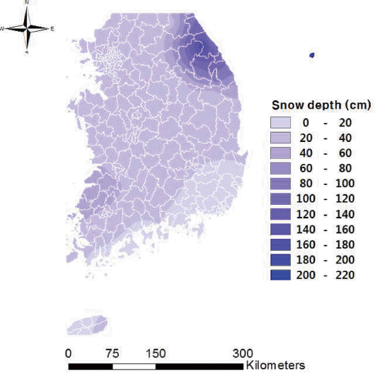
30-yaer recurrence interval snow depth map in Korea.
3. 온실의 적설심 설계기준 적정성 평가
3.1 적설심 설계기준 조사
온실 설계시 활용되고 있는 적설심 설계기준은 원예특작시설 내재해형 규격 설계도·시방서[MAFRA(2014)]에서 Table 3과 같이 행정구역별로 20 cm~40 cm이상으로 제시하고 있다. 또한 지역별 적설심이 설계기준의 최고치인 40 cm를 상회하는 지역은 시설전문기관의 구조해석을 거쳐 설치할 것을 권장하고 있다. 행정구역별 온실의 설계적설심을 Fig. 2와 같이 지도로 작성하였으며 지도를 통해 강원도 동부지역과 전라남·북도 서부 지역에서의 설계 기준이 타 지역보다 크게 책정되어 있는 것을 알 수 있다.

Design snow depth for green house according to administrative districts
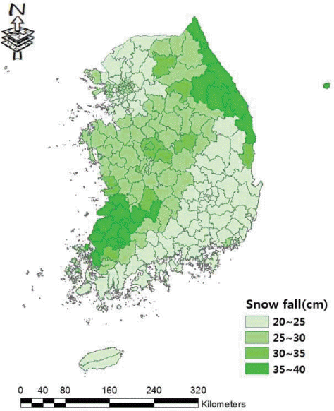
Design snow depth map for green house according to administrative districts.
3.2 적설심 설계기준의 적정성 평가
본 연구에서 산정된 30년 빈도 적설심과 온실 설계기준과의 비교를 통하여 설계기준의 적정성을 평가하여 Table 4에 나타내었다. 비교를 위하여 적설심 설계기준이 40 cm이상인 19개 지역은 40 cm로 간주하고 비교·분석을 수행하였다. 230개 행정구역 중에서 77개 행정구역에서는 설계기준의 적설심이 더 크게 나타나 적정한 것으로 분석되었으며 설계기준의 적설심이 30년 빈도 적설심 보다 작게 산정된 지역은 153개 행정구역으로 나타나 보완이 필요할 것으로 판단된다. 설계기준이 적정한 것으로 판단되는 77개 행정구역에서는 설계기준의 적설심이 본 연구의 30년 빈도 적설심보다 1 cm~8 cm 크게 산정되었으며 평균 2.6 cm 크게 산정된 것으로 분석되었다. 설계기준의 보완이 필요할 것으로 판단되는 153개 행정구역에서는 설계기준의 적설심이 30년빈도 적설심 보다 1 cm~177 cm 작게 산정된 것으로 나타났으며 평균 13 cm 작게 산정된 것으로 분석되었다. 또한, 153개 행정구역을 대상으로Eq. 1을 통해 30년빈도 적설심과 설계기준의 적설심의 차이를 설계기준의 적설심으로 나누고 100을 곱하여 차이비율을 산정하였다. 여기서, 차이비율이란 Eq. 1에 의해 산정된 결과를 말한다. 차이비율을 산정한 결과 Fig. 3과 같이 차이비율이 0%초과 10% 이하인 행정구역은 61개, 10%초과 20%이하는 28개, 20%초과 30%이하는 24개, 30%초과 40%이하는 12개, 40%초과 50%이하는 4개, 50%초과 60%이하는 4개, 60%초과 70%이하는 2개, 70%초과 80%이하는 2개, 80%초과 90%이하는 0개, 90%초과 100%이하는 1개, 100%초과는 15개 지역으로 분석되었다. 차이비율이 100% 초과인 지역은 경상북도 봉화군을 포함한 강원도 대부분의 지역으로 설계기준의 적설심에는 24 cm-40 cm이상으로 제시되어 있으나 30년빈도 적설심을 산정해본 결과 69 cm-215 cm로 나타났다. 설계기준에서 40 cm 이하의 지역으로 구분 된 지역 중 광주, 원주, 완주, 나주, 신안, 제천, 무안, 함평, 군산, 영주, 단양, 순창, 울진, 봉화, 횡성, 영월, 인제, 홍천 등 총 26개 행정구역에서 30년빈도 적설심이 40 cm를 상회하는 것으로 나타났다. 이와 같은 지역은 설계기준에서 제시 한바와 같이 설계기준의 최고치를 상회하는 지역이므로 시설전문기관의 구조해석을 거쳐 구조물을 설치해야 할 것으로 판단된다. 그러나 40 cm 이상이라는 적설심 설계기준은 해당 행정구역의 온실 설치시 주관적인 요소가 개입될 수 있고 구조해석을 거치지 않고 적설심40 cm를 기준으로 온실을 설치할 가능성을 배제할 수 없기 때문에 행정구역별 적설특성에 맞도록 객관적인 적설심 설계기준을 제시하는 것이 좋을 것으로 판단되며 본 연구의 결과가 행정구역별 적설심 설계기준을 결정하는데 도움이 될 것으로 사료된다.

Results of comparison between design snow depth and 30-year recurrence interval snow depth
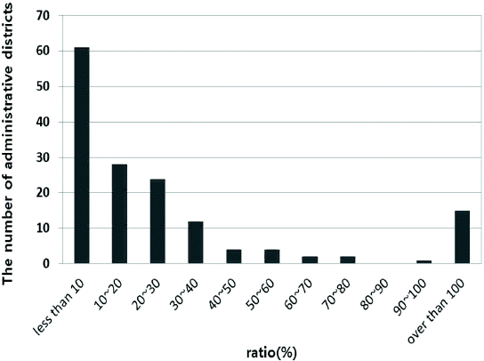
Comparative results of design snow depth and 30-year recurrence interval snow depth.
4. 결론
본 연구에서는 온실의 적설심 설계기준에 대해 평가하기 위해 적설심 빈도분석을 통해 온실의 설계빈도인 30년빈도 적설심을 행정구역별로 산정하였다. 산정된 30년빈도 적설심과 설계기준의 적설심을 비교하여 설계기준에 대해 평가하였으며 본 연구를 통해 도출된 결과를 정리하면 아래와 같다.
(1) 우리나라 69개 기상관측소를 대상으로 빈도분석을 수행하여 기상관측소별 30년빈도 적설심을 산정하였으며 그 결과, 가장 큰 적설심이 산정된 관측소는 경상북도 울릉도 관측소로 215 cm로 산정되었고 두 번째로 큰 적설심이 산정된 관측소는 강원도 대관령 관측소로 179 cm, 세 번째로 큰 적설심이 산정된 관측소는 강원도 동해 관측소로 106 cm로 산정되었다. 가장 낮은 적설심이 산정된 관측소는 제주도의 고산 관측소로 5 cm로 산정되었다.
(2) 기상관측소 위치를 기준으로 30년빈도 적설심을 보간하여 우리나라 전역에 대해 적설심 지도를 작성하고 행정구역별 적설심을 산정하였다. 가장 큰 적설심이 산정된 행정구역은 울릉군으로 215 cm, 이어서 강릉시 180 cm, 평창군 178 cm, 홍천군 126 cm로 산정되었으며 가장 낮은 적설심이 산정된 행정구역은 울산시, 양산시로 15 cm로 산정되었다.
(3) 설계기준의 적설심과 본 연구에서 산정한 30년빈도 적설심을 비교하여 설계기준의 적정성을 평가한 결과, 230개 행정구역 중 77개 행정구역에서는 적정한 것으로 나타났으며 설계기준과의 차이비율이 20%이하인 행정구역은 89개로 설계기준 사용시 주의가 필요할 것으로 판단되며 차이비율이 20% 초과 되는 시군구는 64개인 것으로 나타났다.
본 연구에서 도출된 결과를 통해 행정구역별 온실 적설심설계기준을 평가하여 온실에 대해 30년빈도 폭설에 취약할 수 있는 행정구역을 선정할 수 있었으며 향후 온실 설계 또는 온실 설계기준의 개선에 활용 가능할 것으로 판단된다.
감사의 글
본 연구는 정부(국민안전처)의 재원으로 자연재해저감기술개발사업단의 지원을 받아 수행된 연구임 [MPSS-자연-2013-62].