


1. žĄú Ž°†
Ūēėž≤úžóźžĄúŽäĒ žěźžóį žÉĀŪÉúžóźžĄúžĚė ŪėēžĄĪ Í≥ľž†ēžĚīŽāė žĚłžúĄž†ĀžĚł žÉĀŪô©žúľŽ°ú žĚłŪēī ŪēėŪŹ≠žĚė Ž≥ÄŪôĒÍįÄ ŽįúžÉĚŪēėŽ©į, žĚīžôÄ ÍįôžĚī ŪēėŪŹ≠žĚī ÍłČÍ≤©Ūěą ž§ĄžĖīŽďúŽäĒ ÍĶ¨ÍįĄžóźžĄúŽäĒ Ūôćžąė Ž≤ĒŽěĆžĚė žúĄŪóėžĄĪžĚī Ž≥īŽč§ ŪĀ¨Í≤Ć ž°īžě¨ŪēúŽč§(Kim et al., 2009).
žĚľŽįėž†ĀžúľŽ°ú ŪôćžąėŽäĒ žąėžúĄÍīÄžł°žÜĆ ŽįŹ ÍįēžąėŽüČÍīÄžł°žÜƞ󟞥ú 10Ž∂Ą Žč®žúĄŽ°ú ÍįēžąėŽüȞ̥ ÍīÄžł°Ūēėžó¨ ŽćįžĚīŪĄįŽ•ľ ŪöćŽďĚŪēėŽ©į, žĚīŽ•ľ Ū܆ŽĆÄŽ°ú žąėžúĄžĚĄ ŪĆźŽč®Ūēėžó¨ žėąŽ≥īŽ•ľ ŪēėÍ≥† žěąŽč§. ŪėĄžě¨ žßÄÍĶ¨žė®ŽāúŪôĒ ŽďĪ ÍłįŪõĄŽ¨łž†úŽ°ú žĚłŪēī ŪôćžąėŪĒľŪēīÍįÄ ž¶ĚÍįÄŪēėÍ≥† žěąžúľŽ©į, ÍĶ≠ŽāīžóźžĄúŽäĒ žßÄžěźž≤īŽ≥ĄŽ°ú Ūôćžąėž∑®žēĹžßÄžó≠žóźžĄú Ūôćžąėžčú žúĄŪóė Žč®Í≥ĄŽ•ľ žēĆŽ†§ ž£ľŽĮľŽď§žĚĄ žēąž†ĄŪēėÍ≤Ć ŽĆÄŪĒľžčúŪā§Íłį žúĄŪēī Ūôćžąė ž°įÍłįÍ≤ĹŽ≥īŽįúŽ†Ļ žčúžä§ŪÖúžĚĄ žĄ§ž†ēŪēėÍ≥† žěąŽč§(Lee et al., 2022). žĚī žčúžä§ŪÖúžĚÄ žĚľŽįėž†ĀžúľŽ°ú ŪôćžąėžúĄÍįÄ Í≥Ąžł°ŽźėŽäĒ ÍĶźŽüČžĚė žąėžúĄžóź Žßěž∂ĒžĖī ŽįúŽ†ĻŪēėÍ≥† žěąŽč§.
žĚľŽįėž†ĀžĚł Ūēėž≤úžĚė ŪėēžÉĀÍ≥ľ Žč¨Ž¶¨ ÍłČÍ≤©Ūēú ŪēėŪŹ≠Ž≥ÄŪôĒ ÍĶ¨ÍįĄžĚī žěąŽäĒ Í≤ĹžöįžóźŽäĒ ÍĶźŽüČŽ≥īŽč§ Ūôćžąėžóź ž∑®žēĹŪēú žßÄž†źžĚī ž°īžě¨Ūē† žąė žěąžúľŽ©į, ŪäĻŪěą žĚīŽü¨Ūēú ÍĶ¨ÍįĄžóź žčúžĄ§Ž¨ľžĚī žěąÍĪįŽāė ž£ľŽĮľ ÍĪįž£ľ žßÄžó≠žĚľ Í≤Ĺžöį Ūôćžąėž°įÍłįÍ≤ĹŽ≥ī žčúžä§ŪÖúžĚė Ž¨łž†úÍįÄ ŽďúŽü¨Žā† žąė žěąŽč§. Ž≥ł žóįÍĶ¨žóźžĄúŽäĒ žĚīŽü¨Ūēú ŪäĻžĚīÍĶ¨ÍįĄžóź ŽĆÄŪēú Ž¨łž†úž†źžĚĄ ŪēīžÜĆŪēėÍłį žúĄŪēī žĶúÍ∑ľžóź Ūēėž≤úžóįÍĶ¨žóź ŪôúŽįúŪēėÍ≤Ć žā¨žö©ŽźėÍ≥† žěąŽäĒ Unmanned Aerial Vehicle (UAV) Ūē≠Í≥Ķžł°ŽüČ Íłįžą†žĚĄ žĚīžö©Ūēėžó¨ ž†Āž†ēŪēú ž°įÍłįÍ≤ĹŽ≥īžčúžä§ŪÖúžĚė ŪôćžąėÍ≤ĹŽ≥ī žąėžúĄŽ•ľ žĄ§ž†ēŪēėŽäĒ Žį©Ž≤ēžĚĄ ž†úžčúŪēėÍ≥†žěź ŪēúŽč§.
žĚľŽįėž†ĀžĚł žßĀž†Ďžł°ŽüȞ̥ ŪēėÍłį žúĄŪēīžĄúŽäĒ žė§Žěú žčúÍįĄžĚī žÜĆžöĒŽźėŽ©į, žßÄžÉĀžł°ŽüČÍ≥ľ UAVŽ•ľ žā¨žö©Ūēú žł°ŽüȞ̥ ŽĻĄÍĶźŪēėžėĞ̥ ŽēĆ, UAV žł°ŽüČžĚÄ ŽŹôžĚľŪēú žčúÍįĄŽŹôžēą ŽĻĄÍĶźž†Ā ÍīĎŽ≤ĒžúĄŪēú žėĀžó≠žĚė ŽćįžĚīŪĄįŽ•ľ ŪöćŽďĚŪē† žąė žěąŽč§ŽäĒ žě•ž†źžĚĄ ÍįÄžßÄÍ≥† žěąŽč§(Park and Um, 2018; Ko, 2019). Yeo et al. (2016)žĚÄ UAVŽ•ľ žĚīžö©Ūēú žÜĆŪēėž≤ú žßÄŪėēžěźŽ£Ć ÍĶ¨ž∂ēžóź ÍīÄŪēú Ūö®žú®žĄĪ ž†úÍ≥†žóź ŽĆÄŪēú žóįÍĶ¨Ž•ľ ŪēėžėÄŽč§. Hemmelder et al. (2018)žĚÄ UAV žā¨žßĄžĚĄ žĚīžö©Ūēú Ūēėž≤ú ŪėēŪÉú ŽįŹ ž†úŽį© žĻ®žčĚ Ž™®ŽčąŪĄįŽßĀžóź ŽĆÄŪēú žóįÍĶ¨Ž•ľ žč§žčúŪēėžėÄžúľŽ©į, UAV žā¨žßĄžĚī ÍįēžĚė ŽŹôŪÉúžôÄ ÍįēžĚė ŪėēŪÉú Ž™®ŽčąŪĄįŽßĀžóź ž†ĀŪē©ŪēėŽč§Í≥† ŪĆźŽč®ŪēėžėÄŽč§. Watanabe and Kawahara (2016)žĚÄ Ūēėž≤úžßÄŪėēžĚė Ž≥ÄŪôĒŽ•ľ Ž™®ŽčąŪĄįŽßĀŪēėÍłį žúĄŪēú UAV žā¨žßĄžł°ŽüČžóź ŽĆÄŪēú žóįÍĶ¨Ž•ľ ŪēėžėÄžúľŽ©į, Ūēėž≤úŪėēŪÉú ž†úžěϞ̥ žúĄŪēī UAV žā¨žßĄžł°ŽüČžĚī ž†ĄŽß̞칎č§Í≥† ŪĆźŽč®ŪēėžėÄŽč§. Lee et al. (2017)žĚÄ UAVŽ•ľ Ūôúžö©ŪēėŽäĒ Žį©Ž≤ēžĚÄ ž†ēŪôēŽŹĄ žł°Ž©ī ŽįŹ Í≤Ĺž†úž†Ā žł°Ž©īžóźžĄú Ūö®žú®ž†ĀžĚīŽĚľÍ≥† ŪĆźŽč®ŪēėžėÄŽč§.
žĚīžôÄ ÍįôžĚī, ŪēėŪŹ≠žĚī ͳȎ≥ÄŪēėŽäĒ ÍĶ¨ÍįĄžĚĄ Ž≥īŽč§ Ž©īŽįÄŪěą ŪôēžĚłŪēėÍłį žúĄŪēú Žį©žēąžúľŽ°ú, Íłįž°īžĚė ž£ľžöĒ žßÄž†źŽßƞ̥ žł°ŽüČŪēėŽäĒ Žį©Ž≤ēžóźžĄú Ž≤óžĖīŽāė 3žį®žõźž†ĀžĚł Ž∂ĄžĄĚžĚī ÍįÄŽä•Ūēú UAVŪē≠Í≥Ķžł°ŽüȞ̥ ŪÜĶŪēėžó¨ žĖĽžĖīŽāł Í≥ĶÍįĄž†ēŽ≥īŽ°ú, ÍłČÍ≤©Ūěą Ž≥ÄŪēėŽäĒ Ūēėž≤úÍĶ¨ÍįĄ ŽāīžĚė ŪôćžąėžúĄŽ•ľ Ž∂ĄžĄĚŪēėžó¨ ž°įÍłįÍ≤ĹŽ≥ī žčúžä§ŪÖúžĚė ŪôćžąėžúĄŽ•ľ žĄ§ž†ēŪēėŽäĒ žóįÍĶ¨Ž•ľ žßĄŪĖČŪēėžėÄŽč§.
2. žóįÍĶ¨ Ž≤ĒžúĄ
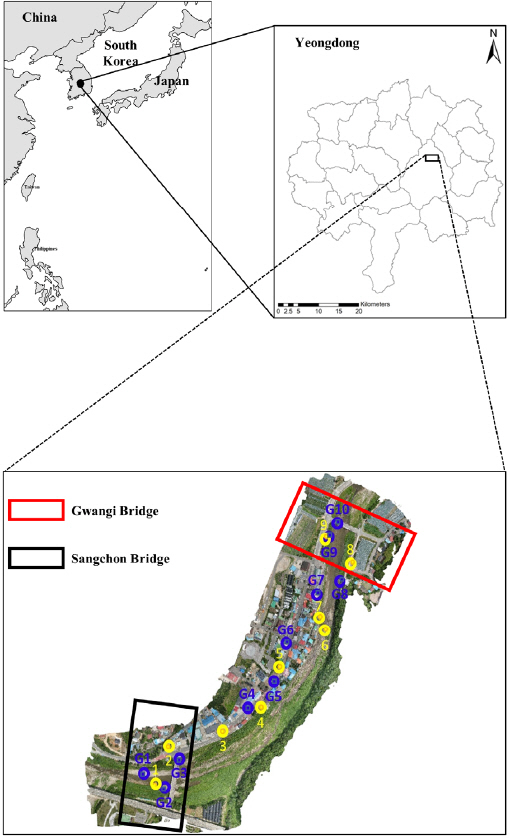
žóįÍĶ¨ŽĆÄžÉĀžßÄŽ°ú Fig. 1žóź ŽāėŪÉÄŽāú ŽįĒžôÄ ÍįôžĚī žėĀŽŹôÍĶį žÉĀžīĆŽ©īžóź žúĄžĻėŪēú žīąÍįēž≤ú Žāī ÍĶ¨žó≠žúľŽ°ú žĄ§ž†ēŪēėžėÄžúľŽ©į, žÉĀŽ•ėžóź žÉĀžīĆÍĶź, ŪēėŽ•ėžóź ÍīÄÍłįÍĶźÍįÄ žúĄžĻėŪēī žěąŽč§. ŽėźŪēú Ūēėž≤úžĚė žöįžēąžóźŽäĒ žāįÍ≥ľ Žį≠ŽďĪžĚī žúĄžĻėŪēú ŽįėŽ©ī žĘĆžēą ž™Ĺžóź žÉĀÍįÄ ŽįŹ ÍĪįž£ľ žčúžĄ§Žď§žĚī žúĄžĻėŪēī žěąŽč§. žĚī ÍĶ¨žó≠žóź ž°įÍłįÍ≤ĹŽ≥ī žčúžä§ŪÖú žĄ§ž†ēžĚĄ žúĄŪēī žÉĀžīĆÍĶź ŽįŹ ÍīÄÍłįÍĶź ŽĎź ÍĶźŽüČžóź žąėžúĄÍ≥ĄŽ•ľ žĄ§žĻėŪēėžó¨ Ūēėž≤úžĚė žąėžúĄŽ•ľ ŪôēžĚłŪēėÍłįŽ°ú ŪēėžėÄŽč§.
Fig. 1
Study Area of Chogang-cheon River, Located in the Province of Yeongdong District, South Korea (Top Panel) and the Orthorectified Mosaic Image Including 10 GCP Points (Blue Color, G1-G10) and 9 Reference Points (Yellow Color, 1-9). The Top Left-side Portion in Fig. 1 Bottom Panel Presents the Location of Each Bridge
žīąÍįēž≤ú žú†žó≠žĚÄ ž†ĄŪėēž†ĀžĚł Ūēėž≤úŽč®Ž©ī ŪėēžÉĀžĚł žÉĀŽ∂Ä, ŪēėžÉĀ, Í≤Ĺžā¨Ž©īžĚĄ ÍįĖž∂ĒÍ≥† žěąžúľŽ©į, 50ŽÖĄ ŽĻąŽŹĄ Í≥ĄŪöćŪôćžąėŽüČžĚÄ 921 m3/sžĚīŽč§. žīąÍįēž≤úžĚÄ žÉĀžīĆŽ©īžĚĄ ŪÜĶŪēī ŪĚźŽ•īŽč§ÍįÄ žč¨ž≤úŽ©ī žč¨ž≤úŽ¶¨žóźžĄú ÍłąÍįē Ž≥łŽ•ėŽ°ú Ūē©Ž•ėŽźúŽč§.
3. žóįÍĶ¨ Žį©Ž≤ē
3.1 UAV Aerial Surveying
Ž≥ł žóįÍĶ¨žóźžĄúŽäĒ žóįÍĶ¨ŽĆÄžÉĀ žßÄžó≠žĚł ž∂©ž≤≠Ž∂ĀŽŹĄ žėĀŽŹôÍĶį žÉĀžīĆŽ©īžóź ŽĆÄŪēėžó¨ ŪēėŪŹ≠ ͳȎ≥ÄŪôĒ ÍĶ¨ÍįĄžĚī ž°īžě¨ŪēėŽäĒ ŽįĒ, Íłįž°īžĚė žßÄž†źžł°ŽüȞ̥ ŪÜĶŪēú Žį©Ž≤ēŽ≥īŽč§ŽäĒ, ŽĄďžĚÄ Ž≤ĒžúĄžĚė 3žį®žõźž†ĀžĚł žł°ŽüȞ̳ ÍįÄŽä•Ūēú UAVžł°ŽüȞ̥ žĪĄŪÉĚŪēėžėÄŽč§. žĚľŽįėž†ĀžúľŽ°ú žßÄž†źžł°ŽüČžúľŽ°úŽäĒ Ūēėž≤ú ͳȎ≥ÄÍĶ¨ÍįĄ ž†Ąž≤īžóź ŽĆÄŪēú žł°ŽüČžĚÄ Ž∂ąÍįÄŽä•ŪēėŽ©į Ž≥īŽč§ ŽßéžĚÄ žčúÍįĄÍ≥ľ žě•ŽĻĄÍįÄ žöĒÍĶ¨ŽźėžßÄŽßĆ UAVŪē≠Í≥Ķžł°ŽüČžĚÄ žÜźžČĹÍ≤Ć žĚīŽ•ľ ŪēīÍ≤į ÍįÄŽä•Ūēú Í≤ÉžúľŽ°ú ŪĆźŽč® UAVŽ•ľ ŪÜĶŪēú Ūē≠Í≥Ķžł°ŽüȞ̥ ž†Āžö©ŪēėžėÄŽč§. 19ÍįúžĚė žßÄž†źžĚĄ žßÄžÉĀžóźžĄú žł°ŽüČŪēėžėÄžúľŽ©į Ground Control Points (GCP)Ž•ľ žßÄž†ēŪēėžó¨ žā¨žßĄžī¨žėĀžĚĄ žßĄŪĖČŪēėžėÄŽč§. GCPŽäĒ ž∂ĒŪõĄ UAVŽ•ľ ŪÜĶŪēú žā¨žßĄžł°ŽüČ žěĎžó֞󟞥ú žėĀžÉĀ žĘĆŪĎúÍ≥ĄžôÄ žßÄŽŹĄ žĘĆŪĎúÍ≥Ą žā¨žĚīžĚė Ž≥ÄŪôėžč̞̥ ÍĶ¨ŪēėÍłį žúĄŪēú Íłįž§Äž†źžúľŽ°ú žā¨žö©ŽźėžóąŽč§. žł°ŽüČŪēú 19ÍįúžĚė žßÄžÉĀžł°ŽüČž†ź ž§ĎžóźžĄú 10ÍįúŽäĒ žā¨žßĄ ŪĒĄŽ°úžĄłžčĪžĚĄ žúĄŪēėžó¨ GCPŽ°ú žā¨žö©ŪēėžėÄžúľŽ©į, ŽāėŽ®łžßÄ 9ÍįúžĚė žł°ŽüČž†źžĚÄ ž†ēŪôēŽŹĄ Ž∂ĄžĄĚ ŽįŹ ŽĻĄÍĶźŽ•ľ žúĄŪēú Í≤Äžā¨ž†źžúľŽ°ú žßÄž†ēŪēėžėÄŽč§. žóįÍĶ¨ŽĆÄžÉĀžĚė žúĄžĻė ŽįŹ ÍįĀ žßÄž†źžóź ŽĆÄŪēú žúĄžĻė ž†ēŽ≥īŽäĒ Fig. 1žĚė ŪēėŽ∂ÄÍ∑łŽ¶ľžóź ŽŹĄžčúŪēėžėÄŽč§(G1~G10, 1~9).
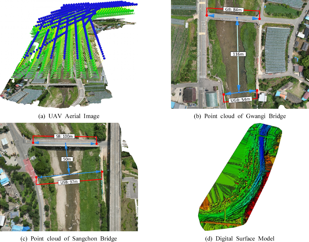
Post-processingžčúžóź ž†ēŪôēŽŹĄŽ•ľ ŽÜížĚīÍłį žúĄŪēī ž†ēŽįÄŽŹĄÍįÄ ŽÜížĚÄ Autelžā¨žĚė EvoIIŽ•ľ žā¨žö©ŪēėžėÄžúľŽ©į žā¨žö©Žźú žĻīŽ©ĒŽĚľžĚė žā¨žĖĎžĚÄ XT701, 1/800 seconds, 4,000 √ó 3,000 pixels, Í∑łŽ¶¨Í≥† ISO-100žĚīŽč§. žā¨žßĄžł°ŽüȞ̥ žúĄŪēėžó¨ Ž®ľž†Ä 10ÍįúžĚė GCPžôÄ 9ÍįúžĚė Í≤Äžā¨ž†źžĚĄ ž†Āž†ēŪēú ÍĪįŽ¶¨žĚė ÍįĄÍ≤©žĚĄ ŽĎźÍ≥† žÉĀŽ∂Ä, ŪēėžÉĀ, Í≤Ĺžā¨Ž©īžóź Í≥†Ž•īÍ≤Ć Ž∂ĄŪŹ¨Ūēėžó¨ žßÄžÉĀžóź žĄ§žĻėŪēėžėÄŽč§. žĄ§žĻėŪēú žßÄž†źŽď§žóź ŽĆÄŪēėžó¨ Global Positioning System (GPS) žł°ŽüȞ̥ Ūēėžó¨ žúĄŽŹĄ, Í≤ĹŽŹĄ, ŪĎúÍ≥† ŽďĪ žúĄžĻėžóź ŽĆÄŪēú ž†ēŽ≥īŽď§žĚĄ ŪöćŽďĚŪēúŽč§. žĚīŪõĄ UAVŽ•ľ ŪÜĶŪēėžó¨ Ūē≠Í≥Ķ žā¨žßĄžī¨žėĀžĚĄ žßĄŪĖČŪēėžėÄžúľŽ©į, žī¨žėĀŽźú Ūē≠Í≥Ķžā¨žßĄžóź ŽĆÄŪēīžĄú 2žį®žõź žā¨žßĄžĚĄ 3žį®žõź Ž™®ŽćłŽßĀžúľŽ°ú Ž≥ÄŪôėŪē† žąė žěąŽäĒ Pix4D žÉĀžö©ŪĒĄŽ°úÍ∑łŽě®žĚĄ žā¨žö©ŪēėžėÄŽč§. žĚīŪõĄ Digital Surface Model (DSM) ŽįŹ ž†ēžā¨žėĀžÉĀžĚĄ ŪöćŽďĚŪēėžėÄžúľŽ©į Quality ReportžĚĄ ŪÜĶŪēėžó¨ Í≤įÍ≥ľÍįížĚė ž†ēŪôēŽŹĄŽ•ľ Í≤Äž¶ĚŪēėžėÄŽč§. žó¨ÍłįžĄú, Pix4DŽäĒ žā¨žßĄžł°ŽüČ, žĽīŪď®ŪĄį žē†ŽčąŽ©ĒžĚīžÖė ŽįŹ remote sensingžóź ŽĄźŽ¶¨ žā¨žö©ŽźėÍ≥† žěąŽč§(Vautherin et al., 2016; Barbasiewicz et al., 2018).
Fig. 2(a)žóź Ūē≠Í≥Ķ žā¨žßĄžł°ŽüȞ̥ ŪÜĶŪēī ŪöćŽďĚŪēú ž†ēžā¨Ūē©žĄĪ žā¨žßĄžĚĄ ŽāėŪÉÄŽāīžóąžúľŽ©į, Figs. 2(b)žôÄ (c)žóźŽäĒ ÍīÄÍłįÍĶźžôÄ žÉĀžīĆÍĶźžĚė Point cloud žěźŽ£ĆŽ•ľ ŽāėŪÉÄŽāīžóąŽč§. Fig. 2(a)žĚė ŪĆĆŽěÄžÉČ ÍĶ¨ŪėēžĚÄ žīąÍłį žĻīŽ©ĒŽĚľ žúĄžĻėŽ•ľ ŽāėŪÉÄŽāīŽ©į, žīąŽ°ĚžÉČ ÍĶ¨ŪėēžĚÄ Í≥ĄžāįŽźú 3D žĻīŽ©ĒŽĚľ žúĄžĻėŽ•ľ ŽāėŪÉÄŽāłŽč§. ŪĆĆŽěÄžÉČ ÍĶ¨ŪėēÍ≥ľ žīąŽ°ĚžÉČ ÍĶ¨Ūėē žā¨žĚīžĚė ŽÖłŽěÄ žĄ†žĚÄ žīąÍłį žĻīŽ©ĒŽĚľ žúĄžĻėžôÄ 3D žĻīŽ©ĒŽĚľ žúĄžĻėžĚė žį®žĚīŽ•ľ Ž≥īžó¨ž§ÄŽč§. žĚī 3D žĻīŽ©ĒŽĚľžĚė žúĄžĻė žĄ§ž†ēžĚÄ Pix4Džóź ŪÉϞ쨎źėžĖī žěąŽäĒ žēĆÍ≥†Ž¶¨ž¶ėžĚĄ ŪÜĶŪēī ÍįÄŽä•ŪēėŽč§. Pix4DŽäĒ ŽŹôžĚľ žā¨Ž¨ľžĚĄ Žč§Ž•ł žčúž†źžóźžĄú ž∑®ŽďĚŪēėžó¨ 2D žā¨žßĄžĚĄ žóźŪĒľŪŹīŽĚľ ÍłįŪēėŪēôžĚĄ žā¨žö©Ūēėžó¨ 3D žěÖž≤ī žėĀžÉĀžúľŽ°ú Ž≥ÄŪôėžčúŪā¨ žąė žěąŽäĒ 3žį®žõź žě¨ÍĶ¨žĄĪ žēĆÍ≥†Ž¶¨ž¶ėžĚī ŪÉϞ쨎źėžĖī žěąŽč§. Ž®ľž†Ä, Žč§žĖĎŪēú Žį©Ž©īžóźžĄú žįćžĚÄ žĚīŽĮłžßĞ󟞥ú ŪäĻžßēž†źžĚĄ Í≤Äž∂úŪēú ŪõĄ, žóźŪĒľŪŹīŽĚľ ÍłįŪēėŪēôžĚĄ žā¨žö©ŪēúŽč§. žĚīŽ•ľ ŪÜĶŪēī žĻīŽ©ĒŽĚľŽď§ žā¨žĚīžĚė žÉĀŽĆÄž†ĀžĚł žúĄžĻė ŽįŹ Žį©ŪĖ•žĚĄ ž∂Ēž†ēŪē† žąė žěąÍ≤Ć ŽźėŽ©į, žĻīŽ©ĒŽĚľžĚė 3žį®žõź žúĄžĻėŽ•ľ ž∂Ēž†ēŪēėÍ≤Ć ŽźúŽč§. žĚī Í≥ľž†ēžĚĄ ŽįėŽ≥ĶŪēėÍ≤Ć ŽźėŽ©ī ž∂ĒŪõĄ 3D žĻīŽ©ĒŽĚľ žúĄžĻėÍįÄ Í≤įž†ēŽźúŽč§(Kwon et al., 2020). Figs. 2(b)žôÄ (c)žóź ÍīÄÍłįÍĶź ŽįŹ žÉĀžīĆÍĶźžĚė Point CloudŽ•ľ ŽāėŪÉÄŽāīžóąžúľŽ©į žĚīŽ•ľ ŪÜĶŪēī ŽßƎ吏ĖīžßĄ DSMžĚĄ Fig. 2(d)žóź ŽāėŪÉÄŽāīžóąŽč§.
Fig. 2
Aerial Image Taken by UAV is Shown in Panel (a). Note that the Blue Globular Shapes Indicate the Intial Camera Locations and the Green Globular Shapes Indicate the Calcuated Camera Locations. The Yellow Lines Show the Difference between the Initial and Calculated 3D Camera Locations and the Photos Taken from UAV are Shown below the Green Globular Shapes. Panel (b) and Panel (c) Represents the Point Clouds of Gwangi Bridge and Sangchon Bridge. The Digital Surface Model Generated Through Point Cloud and Mesh is Shown in Panel (d)
3.2 žąėŽ¶¨žąėŽ¨ł Ž™®Ūėē(HEC-RAS)
HEC-RASžóź žßĀž†Ďžł°ŽüČ ŽįŹ UAV Ūēėž≤úžł°ŽüȞ̥ ŪÜĶŪēī ŪöćŽďĚŪēú ÍįíŽď§žĚĄ žěÖŽ†•Ūēėžó¨ ÍįĀ Ūēėž≤úŽč®Ž©īžĚė žąėžúĄ ŽįŹ žú†ŽüȞ̥ ŪôēžĚłŪēėžėÄŽč§. River Reachžóź žÉĀŽ•ėžóźžĄú ŪēėŽ•ėŽ°ú Íįą ŽēĆžĚė Žį©ŪĖ•žĚĄ ŽāėŪÉÄŽāīŽäĒ žĄ†žĚĄ Í∑łŽ¶į ŪõĄ Cross Section DataŽ•ľ žěÖŽ†•Ūēėžó¨ žĄ§ž†ēŪēú ÍįĀ Ūēėž≤úŽč®Ž©ī žā¨žĚīžĚė ÍĪįŽ¶¨, ž°įŽŹĄÍ≥Ąžąė, žł°ŽüČŪēú ž†źŽď§žĚė ŪĎúÍ≥†žôÄ ÍįĀ ž†źŽď§ žā¨žĚīžĚė ÍĪįŽ¶¨Ž•ľ žěÖŽ†•ŪēúŽč§. žĚīŪõĄ Steady Flow DataŽ•ľ žěÖŽ†•Ūēėžó¨ Steady Flow AnalysisŽ•ľ ŪÜĶŪēī ŽŹôžĚľŪēú žú†ŽüČžĚī ŪĚźŽ•ľ ŽēĆ ÍįĀ Ūēėž≤úŽč®Ž©īžĚė žąėžúĄŽ•ľ žēĆÍ≤Ć ŽźúŽč§.
4. Í≤į Í≥ľ
4.1 ŽďúŽ°† žł°ŽüČ
žóįÍĶ¨ŽĆÄžÉĀžĚł ÍīÄÍłįÍĶźžóźžĄú žÉĀžīĆÍĶźÍĻĆžßÄ ŽďúŽ°†žī¨žėĀžĚĄ žč§žčúŪēėžėÄžúľŽ©į žī¨žėĀŽźú Ūē≠Í≥Ķžā¨žßĄžóź ŽĆÄŪēīžĄú Pix4D žÉĀžö©ŪĒĄŽ°úÍ∑łŽě®žĚĄ žĚīžö©Ūēėžó¨ point cloud dataŽ•ľ ŪöćŽďĚŪēėžėÄŽč§. Cho et al. (2020)žĚÄ 3D ÍĶ¨ž∂ē ŽįŹ ž†ēžā¨žėĀžÉĀžĚĄ ŪēúŽ≤ąžĚė žī¨žėĀžúľŽ°ú ž†ĀŪē©ŪēėÍ≤Ć Ūē† žąė žěąŽäĒ ž°įÍĪīžĚÄ žī¨žėĀÍ≥†ŽŹĄ 50~100 m žā¨žĚīŽĚľÍ≥† Ž™ÖžčúŪēėžėÄžúľŽ©į, žĚīŽ•ľ Í≥†Ž†§Ūēėžó¨ žł°ŽüČžčú ŽĻĄŪĖČÍ≥†ŽŹĄŽäĒ 80 mŽ°ú žĄ§ž†ēŪēėžėÄŽč§. 10ÍįúžĚė GCPžôÄ 9ÍįúžĚė Í≤Äžā¨ž†źžóź ŽĆÄŪēú žł°ŽüČžė§žį®Ž•ľ Table 1žóź ŽāėŪÉÄŽāīžóąŽč§. žł°ž†ēžė§žį®ŽäĒ žĚľŽįėž†ĀžúľŽ°ú Root Mean Square Error (RMSE)Ž°ú ÍĶ¨Ūēīžßźžóź ŽĒįŽĚľ(Mart√≠nez-Carricondo et al., 2018) Ž≥ł žóįÍĶ¨žóźžĄú ŽėźŪēú RMSEŽ•ľ ž†Āžö©ŪēėžėÄžúľŽ©į žčĚžĚÄ žēĄŽěėžôÄ ÍįôŽč§. xiŽäĒ ŪėĄžě•žł°ŽüȞ̥ ŪöćŽďĚŪēú ÍįížĚīŽ©į, XiŽäĒ UAVžł°ŽüČ ŽįŹ Pix4D postprocessingžĚĄ ŪÜĶŪēī žĖĽžĚÄ ÍįížĚĄ žĚėŽĮłŪēúŽč§. nžĚÄ žěźŽ£ĆžĚė ÍįĮžąėŽ•ľ ŽāėŪÉÄŽāłŽč§.
Table 1
Information of the Error of 10 GCP Points and 9 Reference Points in the Bottom Panel of Fig. 1
(ÍĶ≠Ū܆žßÄŽ¶¨ž†ēŽ≥īžõźÍ≥†žčú ž†ú2022-3487Ūėł)žĚė Ūē≠Í≥Ķžā¨žßĄžł°ŽüČ žěĎžóÖÍ∑úž†ē ž†ĄŽ∂ÄÍįúž†ēžēąžóź ŽĒįŽĚľžĄú RMSEžĚė ÍįížĚÄ Average Ground Sampling Distance (GSD)žĚė Íįí žēąžúľŽ°ú Žď§žĖīžôÄžēľ ŪēėŽ©į, žĶúŽĆÄ žė§žį® ŪēúÍ≥ĄŽäĒ GSD ÍįížĚė 2ŽįįŽ°ú Í∑úž†ēŽźėžĖī žěąŽč§. žĚīžóź ŽĆÄŪēú ŪĎúŽäĒ žēĄŽěė Table 2žóź ŽāėŪÉÄŽāīžóąŽč§. ŪöćŽďĚŪēú GSDžĚė ÍįížĚÄ 2.65 cmžĚīŽ©į, Tables 1Í≥ľ 2Ž•ľ ŪÜĶŪēī GCPžĚė X, Y, Z žė§žį® Ž™®ŽĎź žė§žį®Ž≤ĒžúĄ žēąžóź žěąžĚƞ̥ ŪôēžĚłŪēėžėÄŽč§. ŽėźŪēú Í≤Äžā¨ž†ź(RP)ŽäĒ GCPžôÄ Žč¨Ž¶¨ ŪĒĄŽ°úžĄłžčĪžóź žā¨žö©ŽźėžßÄ žēäÍ≥† ž†ēŪôēŽŹĄ Ž∂ĄžĄĚžĚĄ žúĄŪēú Í≤Äžā¨ž†źžúľŽ°úŽßĆ žā¨žö©ŽźėžóąÍłį ŽēĆŽ¨łžóź RP errorÍįÄ GCP erroržóź ŽĻĄŪēī ŪĀį Í≤ÉžúľŽ°ú ŽāėŪÉÄŽā¨Žč§.
4.2 žú†ž∂úŽüČ Ž∂ĄžĄĚ
Figs. 3, 4žóźžĄú Ž≥īžĚīŽäĒ ŽįĒžôÄ ÍįôžĚī Gwangi Bridge (GB), Upstream of Gwangi Bridge (UGB), Sangchon Bridge (SB), Upstream of Sangchon Bridge (USB)Ž°ú ŽāėŪÉÄŽāīžóąžúľŽ©į, ŽĄ§ Žč®Ž©īžĚė žúĄžĻė ŽįŹ ÍĪįŽ¶¨ŽäĒ Fig. 5žóź ŽŹĄžčúŪēėžėÄŽč§. žĚīŽäĒ ÍįĀÍįĀ ÍĶźŽüČÍ≥ľ ÍĶźŽüČžĚė žÉĀŽ•ėžßÄž†źžĚė žú†ŽüȞ̥ ŪĆźŽč®ŪēėÍłį žúĄŪēú žł°ŽüČžĚė Í≤ĹÍ≥ĄŽ°ú žĄ§ž†ēŽźėžóąŽč§.
Fig. 3
HEC-RAS Model of (a) Gwangi Bridge (GB), (b) Upstream of Gwangi Bridge (UGB), © Sangchon Bridge (SB), (d) Upstream of Sangchon Bridge (USB) Indicating the Stream EL. of Three Steps for an FEWS (Caution, Warning, Evacuation)
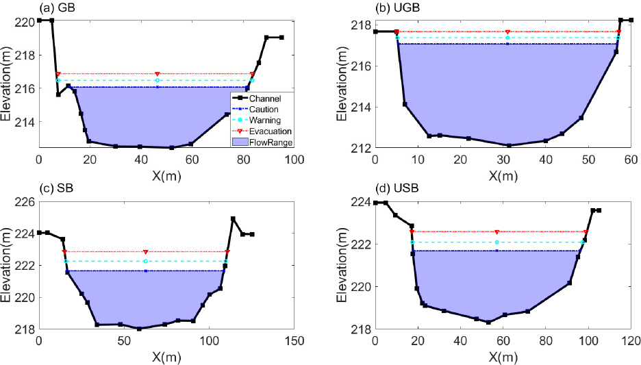
Fig. 4
Water EL of Gwangi Bridge (GB) and Upstream of Gwangi Bridge (UGB) when the Flood Occurs at Gwangi Bridge
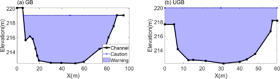
Fig. 5
Four River Cross-sections (Gwangi Bridge, Upstream of Gwangi Bridge, Sangchon Bridge, Upstream of Sangchon Bridge). Note that the Distance between Gwangi Bridge and Upstream of Gwangi Bridge is 116 m and the Distance between Sangchon Bridge and Upstream of Sangchon Bridge is 50 m. The Distance between the two Bridges is 819 m
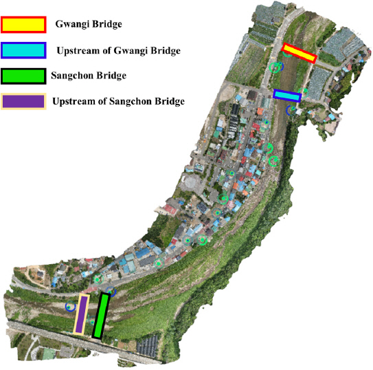
Fig. 2(b)žóźžĄú Ž≥īŽäĒ ŽįĒžôÄ ÍįôžĚī ÍīÄÍłįÍĶź žÉĀŽ•ė 116 m žßÄž†źžóź ŪēėŪŹ≠žĚī ͳȎ≥ÄŪēėÍ≥† ŪēīŽčĻ žúĄžĻėžĚė žĘĆžēąžóź žÉĀžóÖžčúžĄ§ ŽįŹ ÍĪįž£ľžčúžĄ§žĚī ŽįÄžßĎŪēī žěąŽäĒ Í≤ɞ̥ ŪôēžĚłŪēėžėÄŽč§. ŽėźŪēú ŪēīŽčĻ žúĄžĻėžĚė ž†úŽį©ŽÜížĚīžôÄ ž†úŽāīžßÄžĚė ŪĎúÍ≥†ÍįÄ žÉĀŽčĻŪēú žį®žĚīŽ•ľ Ž≥īžĚīÍ≥† žěąžĖī Ūôćžąė Ž≤ĒŽěĆžčú žĚīÍ≥Ķ ž†Ąž≤īžóź ŪôćžąėŽ≤ĒŽěĆžĚī ŪĀ¨Í≤Ć ŽįúžÉĚŪē† žąė žěąžĚĄ Í≤ÉžúľŽ°ú ŪĆźŽč®ŽźúŽč§. ÍīÄÍłįÍĶźžĚė ÍĶźŽüČ ÍłłžĚīŽäĒ 84 mžĚīŽ©į, Pix4D žÉĀžö©ŪĒĄŽ°úÍ∑łŽě®žĚĄ ŪÜĶŪēī Ūôćžąėžóź ž∑®žēĹŪēī Ž≥īžĚīŽäĒ žÉĀŽ•ėžßÄž†źžĚė ŪēėŪŹ≠žĚÄ Fig. 2(b)žóźžĄúžôÄ ÍįôžĚī 54 mžěĄžĚĄ ŪôēžĚłŪēėžėÄŽč§. ŽėźŪēú žÉĀžīĆÍĶźžĚė ÍĶźŽüČÍłłžĚīŽäĒ 100 mžĚīŽ©į, Pix4DŽ•ľ ŪÜĶŪēī žÉĀŽ•ėžßÄž†źžĚė ŪēėŪŹ≠žĚÄ 97 mžěĄžĚĄ ŪôēžĚłŪēėžėÄŽč§.
Fig. 2(c)žóź žÉĀžīĆÍĶź ŽėźŪēú žÉĀŽ•ėžßÄž†źžóźžĄú ŪėĎžÜĆŪēú ŪēėŪŹ≠žĚė Ūēėž≤úŽč®Ž©īžĚĄ ŪôēžĚłŪēėžėÄžúľŽ©į, 3 mžĚė žį®žĚīÍįÄ ŽāėŽäĒ Í≤ÉžúľŽ°ú ŪôēžĚłŪēėžėÄŽč§. žÉĀŽ•ėžßÄž†źÍ≥ľ ŽĻĄÍĶźŪēėžėĞ̥ ŽēĆ 30 mžĚė žį®žĚīÍįÄ ŽāėŽäĒ ÍīÄÍłįÍĶźžóźžĄúžĚė Ūēėž≤ú Žč®Ž©īŽßĆŪĀľ ͳȎ≥ÄŪēėžßÄŽäĒ žēäžēĄ ÍīÄÍłįÍĶźÍįÄ Ūôćžąėžóź ŽćĒ ž∑®žēĹŪē† Í≤ÉžúľŽ°ú ŪĆźŽč®ŽźėžĖī ÍīÄÍłįÍĶźŽ•ľ ž§Ďžč¨žúľŽ°ú Ž∂ĄžĄĚžĚĄ žßĄŪĖČŪēėžėÄŽč§. žĚīŽ•ľ ŪÜĶŪēī ÍīÄÍłįÍĶźžóź ŽŹĄŽč¨ŪēėÍłį ž†Ą ÍīÄÍłįÍĶźžĚė žÉĀŽ•ėžßÄž†źžóźžĄú Ž®ľž†Ä Ž≤ĒŽěĆžĚī žĚľžĖīŽā† Í≤ÉžúľŽ°ú žėąžł°ŽźėžóąŽč§. žąėžúĄÍ≥ĄÍįÄ ÍīÄÍłįÍĶźžóź žĄ§žĻėŽźėžĖī žąėžúĄžĚė žł°ž†ēžĚī ÍīÄÍłįÍĶźžĚė žõĒŽ•ėŽ•ľ Íłįž§ÄžúľŽ°ú Ūē† Í≤Ĺžöį žč§žßąž†ĀžúľŽ°ú ŪĒľŪēīÍįÄ žėąžÉĀŽźėŽäĒ ÍīÄÍłįÍĶź žÉĀŽ•ėžĚė Ūôćžąėž∑®žēĹÍĶ¨ÍįĄžóź ŽĆÄŪēú Í≤ĹŽ≥īÍįÄ ž†Āž†ēŪēú žčúÍłįžóź žĚīŽ£®žĖīžßÄÍłį ŪěėŽď§ Í≤ÉžúľŽ°ú ŪĆźŽč®ŽźėžóąŽč§. žĚīŽ•ľ ŪēīÍ≤įŪēėÍłį žúĄŪēī HEC-RASŽ•ľ žā¨žö©Ūēėžó¨ ÍīÄÍłįÍĶź žÉĀŽ•ėžĚė Ūôćžąėž∑®žēĹžßÄžēŞ󟞥ú žõĒŽ•ėŽ•ľ Íłįž§ÄžúľŽ°ú ŪôćžąėžúĄŽ•ľ Í≤įž†ēŪēėÍ≥† žĚīŽēĆžĚė ŪôćžąėŽüȞ̥ žāįž†ēŪēėžó¨ žąėžúĄÍ≥ĄÍįÄ žĄ§žĻėŽźėŽäĒ ÍīÄÍłįÍĶźžĚė ŪēīŽčĻ ŪôćžąėŽüČžĚė žąėžúĄŽ•ľ žĄ§ž†ēŪēėŽŹĄŽ°Ě ŪēėžėÄŽč§.
4.3 ž°įÍłįÍ≤ĹŽ≥ī žĄ§ž†ē
ž°įÍłįÍ≤ĹŽ≥ī žĄ§ž†ēžĚĄ žúĄŪēī Ž®ľž†Ä ÍīÄÍłįÍĶź ŽįŹ ÍīÄÍłįÍĶźžĚė žÉĀŽ•ė Ūôćžąėž∑®žēĹžßÄžó≠, Í∑łŽ¶¨Í≥† žÉĀžīĆÍĶź ŽįŹ žÉĀžīĆÍĶź žÉĀŽ•ėžĚė Ūôćžąėž∑®žēĹžßÄžó≠žóź ŽĆÄŪēú Žč®Ž©īžĚė ŪôćžąėŽ∂ĄžĄĚžĚĄ žč§žčúŪēėžėÄŽč§. Í≤įÍ≥ľž†ĀžúľŽ°ú, ŽĄ§ Žč®Ž©ī ž§Ď ÍīÄÍłįÍĶź žÉĀŽ•ėžßÄž†źžóźžĄú Ž≤ĒŽěĆžĚī ÍįÄžě• Ž®ľž†Ä žĚľžĖīŽāėŽäĒ Í≤ÉžúľŽ°ú Ž∂ĄžĄĚŽźėžóąŽč§(Fig. 2). Ž≤ĒŽěĆžĚī žĚľžĖīŽā† ŽēĆžĚė žú†ŽüČžĚÄ Í≥ĄŪöćŪôćžąėŽüČ(921 m3/s)žĚė 300%žóź ŪēīŽčĻŪēėŽäĒ žú†ŽüȞ쥞̥ ŪôēžĚłŪēėžėÄŽč§. žĚīŽ•ľ ŪÜĶŪēī ž°įÍłįÍ≤ĹŽ≥ī ŽįúŽ†Ļ žčúžä§ŪÖúžĚĄ ÍįÄžě• Ž®ľž†Ä Ž≤ĒŽěĆŪēėŽäĒ ÍīÄÍłįÍĶź žÉĀŽ•ėžßÄž†źžóź Žßěž∂ĒžóąžúľŽ©į, Ž≤ĒŽěĆŪēėŽäĒ žčúž†źžĚł ŪôćžąėŽüČ 300%Ž•ľ ŽĆÄŪĒľ Žč®Í≥ĄŽ°ú 3Žč®Í≥ĄžĚė ŪôćžąėÍ≤ĹŽ≥īŽ•ľ Table 3žóźžĄú Ž≥īžĚīŽäĒ ŽįĒžôÄ ÍįôžĚī žĄ§ž†ēŪēėžėÄŽč§. žĚľŽįėž†ĀžúľŽ°ú ŪôćžąėÍ≤ĹŽ≥īŽäĒ žöįŽ¶¨ŽāėŽĚľžĚė Í≤Ĺžöį ž£ľžĚėŽ≥ī, Í≤ĹŽ≥ī, ŽĆÄŪĒľ žĄł Žč®Í≥Ąžóź ŽĒįŽĚľ ŽįúŽ†ĻŽźėŽ©į, ÍįĀ ÍłįÍīÄŽßąŽč§ Žč§Ž•ł Íłįž§ÄŽď§žĚĄ ž†úžčúŪēėÍ≥† žěąŽč§. žĚīŽü¨Ūēú Íłįž§Ä ž§ĎžóźžĄú ÍįÄžě• ž§ĎžöĒŪēú žā¨Ūē≠žĚÄ ž†úŽį©žóź žõĒŽ•ėÍįÄ ŽįúžÉĚŪēėŽäĒ žąėžúĄŽ•ľ ŽĆÄŪĒľ Íłįž§ÄžúľŽ°ú žāľŽäĒ Í≤ÉžĚīŽ©į, žĚīŽ•ľ Ū܆ŽĆÄŽ°ú ž£ľžĚėŽ≥ī ŽįŹ Í≤ĹŽ≥īÍįÄ Í∑ł žēĄŽěė žąėžúĄžóźžĄú Í≤įž†ēŽźúŽč§ŽäĒ Í≤ÉžĚīŽč§. ŽĒįŽĚľžĄú, Ž≥ł žóįÍĶ¨žóźžĄúŽäĒ žĘĆžēąžóź ÍĪįž£ľžčúžĄ§žĚī žěąžĚƞ̥ ÍįźžēąŪēėžó¨, ŽĆÄŪĒľžčúÍįĄžĚĄ Í≥†Ž†§Ūēėžó¨ žĚīŽ•ł žčúÍłįžóź ž°įÍłįÍ≤ĹŽ≥ī ŽįúŽ†Ļ žóÜžĚīŽäĒ Í∑ľž≤ė ž£ľŽĮľŽď§žĚī ŽįĒŽ°ú ŽĆÄŪĒľŪēėÍłį žĖīŽ†§žöł Í≤ÉžúľŽ°ú Ž≥īžó¨ Ž≤ĒŽěĆžĚė žúĄŪóėžóź Í∑ľÍĪįŪēėžó¨ 50ŽÖĄ ŽĻąŽŹĄ Í≥ĄŪöćŪôćžąėŽüȞ̳ 921 m3/sžĚė 300%žĚł 2,763 m3/sžĚľ ŽēĆ ÍīÄÍłįÍĶź žÉĀŽ•ėžßÄž†źžóźžĄú Ž≤ĒŽěĆžĚī žĚľžĖīŽā®žóź ŽĒįŽĚľ 200%, 250%, 300%žóź ŪēīŽčĻŪēėŽäĒ žąėžúĄŽ•ľ ž£ľžĚėŽ≥ī, Í≤ĹŽ≥ī, ŽĆÄŪĒľ ŽįúŽ†Ļ Íłįž§ÄžúľŽ°ú žĄ§ž†ēŪēėžėÄŽč§. 150ŽÖĄ ŽĻąŽŹĄ ŪôćžąėŽüȞ̾ ŽēĆ 1,163 m3/sžĚīžóąžúľŽāė žĚīŽ•ľ Ūõ®žĒ¨ žÉĀŪöĆŪēėŽäĒ ŪôćžąėŽüȞ󟞥ú Ž≤ĒŽěĆžĚī ŽįúžÉĚŪēėŽäĒ Í≤ÉžúľŽ°ú ŪĆźŽč®ŽźėžĖī žč§ž†ú Ūôćžąė Ž≤ĒŽěĆžĚė ÍįÄŽä•žĄĪžĚÄ Ų̄ŽįēŪēėŽāė, Ūôćžąė Ž≤ĒŽěĆžčú ŽįúžÉĚŽź† žĚłŽ™Ö ŪĒľŪēīŽßĆžĚÄ ŽßȞ̥ žąė žěąŽäĒ žĶúžÜĆŪēúžĚė žě•žĻėžĚł ŽĻĄÍĶ¨ž°įž†Ā Ūôćžąė ŽĆÄžĪÖžúľŽ°ú ž°įÍłįÍ≤ĹŽ≥īŽįúŽ†Ļ žčúžä§ŪÖúžĚī ŪēĄžöĒŪē† Í≤ÉžúľŽ°ú Ž∂ĄžĄĚŽźėžóąŽč§. Í≥ĄŪöćŪôćžąėŽüČžĚė 200%, 250%, 300% Íłįž§Äžóź ŪēīŽčĻŪēėŽäĒ ŽĄ§ Žč®Ž©īžĚĄ HEC-RAS Ž™®ŪėēžúľŽ°ú Fig. 3 ŽįŹ Table 3žóź ŽāėŪÉÄŽāīžóąŽč§. Žßƞ̾ ÍīÄÍłįÍĶźŽ•ľ Íłįž§ÄžúľŽ°ú Ūē† Í≤ĹžöįžĚė ŪôćžąėÍįÄŽä•žĄĪžĚĄ Ž∂ĄžĄĚŪēėÍłį žúĄŪēī ÍīÄÍłįÍĶźžóźžĄú Ž≤ĒŽěĆŪē† ŽēĆžĚė ŪĎúÍ≥†Ž•ľ Fig. 4(a)žóź ŽāėŪÉÄŽāīžóąžúľŽ©į, žĚīŽ•ľ Íłįž§ÄžúľŽ°ú ÍīÄÍłįÍĶź žÉĀŽ•ėžßÄž†źžóźžĄúžĚė ŪĎúÍ≥† ŽįŹ žąėžúĄŽ•ľ ÍįĀÍįĀ Fig. 4(b)žôÄ Table 4žóź ŽāėŪÉÄŽāīžóąŽč§. ÍīÄÍłįÍĶź žÉĀŽ•ėžßÄž†źžĚė Ž≤ĒŽěĆ žú†ŽüȞ̳ Í≥ĄŪöćŪôćžąėŽüČžĚė 300%žóź Žßěž∂ĒžĖī ŽįúŽ†ĻŪēúŽč§Ž©ī ÍīÄÍłįÍĶźžóźžĄúžĚė ŽĆÄŪĒľ EL.žĚÄ 216.88 mžĚīŽ©į, ÍīÄÍłįÍĶźžóźžĄúžĚė Ž≤ĒŽěĆžóź Žßěž∂ĒžĖī ŽįúŽ†ĻŪēúŽč§Ž©ī ŽĆÄŪĒľ EL.žĚÄ 219.06 mžĚīŽč§. žĚīŽ•ľ ŪÜĶŪēī ÍīÄÍłįÍĶźžóźžĄú Ž≤ĒŽěĆžĚī žĚľžĖīŽā† ŽēĆ žĚīŽĮł ÍīÄÍłįÍĶź žÉĀŽ•ėžßÄž†źžóźžĄúŽäĒ Ūõ®žĒ¨ žĚīž†Ąžóź Ž≤ĒŽěĆžĚī Ž®ľž†Ä ŽįúžÉĚŪĖąžĚƞ̥ ŪôēžĚłŪē† žąė žěąŽč§.
Table 3
EL. and Water Levels (m) from the Riverbed for the Applied Flood of FEWS (Four Cross-sections)
5. Í≤į Ž°†
Ūôćžąėž°įÍłįÍ≤ĹŽ≥īžčúžä§ŪÖúžĚÄ ŪôćžąėŽ≤ĒŽěĆžĚė žúĄŪóėŪē®žĚĄ ŽĮłŽ¶¨ žēĆŽ†§ž£ľŽäĒ žēĆŽ¶ľžúľŽ°ú Ž≤ĒŽěĆžĚī žĚľžĖīŽāėÍłį ž†Ą ŽįúŽ†ĻŪēėžó¨ žĚłŽ™Ö ŪĒľŪēīŽ•ľ žĶúžÜĆŪôĒžčúŪā§ŽäĒŽćį Í∑ł Ž™©ž†ĀžĚī žěąŽč§. ŪēėžßÄŽßĆ, žĚľŽįėž†ĀžúľŽ°ú ŪôćžąėžúĄžĚė Í≥Ąžł°žĚī ÍĶźŽüȞ̥ ž§Ďžč¨žúľŽ°ú žĚīŽ£®žĖīž†ł žěąžĖī ž£ľžĚė, Í≤ĹŽ≥ī, ŽĆÄŪĒľ ŽįúŽ†Ļ Íłįž§ÄžĚĄ ÍĶźŽüȞ󟞥úžĚė Íłįž§ÄžúľŽ°ú Ūē† Í≤Ĺžöį ÍīÄÍłįÍĶźžĚė žā¨Ž°ÄžôÄ ÍįôžĚī Ūēėž≤úžĚī ͳȎ≥ÄŪēėŽäĒ ÍĶ¨ÍįĄžóźžĄúŽäĒ žÉĀŽ•ėžßÄž†źžóźžĄú Ž®ľž†Ä Ž≤ĒŽěĆŪēėŽäĒ žÉĀŪô©žĚī ŽįúžÉĚŽźėžĖī ž°įÍłįÍ≤ĹŽ≥īžčúžä§ŪÖúžĚī ž†úŽĆÄŽ°ú Ūôúžö©Žź† žąė žóÜŽč§.
ŽĒįŽĚľžĄú, Ūēėž≤úŽč®Ž©īžĚī ͳȎ≥ÄŪēėžó¨ ÍĶźŽüČžĚė žÉĀŽ•ėžßÄž†źžóźžĄú ÍłįŽ≤ĒŽěĆŪēėŽäĒ žÉĀŪô©žóźŽäĒ ÍĶźŽüČŽ≥īŽč§ ÍĶźŽüČžĚė žÉĀŽ•ėžóź žúĄžĻėŪēú Ūôćžąėž∑®žēĹžßÄž†źžúľŽ°ú Ž≥īžĚīŽäĒ Ūēėž≤úŽč®Ž©īžĚĄ Í≥†Ž†§Ūēīžēľ Ūē† Í≤ÉžúľŽ°ú Ž≥īžĚłŽč§. žĚīŽ•ľ žúĄŪēīžĄúŽäĒ žĚłÍ∑ľ žßÄž†źŽď§žĚĄ ŪŹ≠ŽĄďÍ≤Ć žßÄž†ź žł°ŽüȞ̥ ŪÜĶŪēėžó¨ ž°įžā¨Ūēėžó¨žēľ ŪēėŽāė, Í≤Ĺž†úž†Ā žčúÍįĄž†Ā žĚīžú†Ž°ú ŪėĄ žÉĀŪô©žóźžĄúŽäĒ žĖīŽ†§žõÄžĚī ŪĀ¨Žč§. Ž≥ł žóįÍĶ¨žóźžĄúŽäĒ žĚīŽ•ľ žúĄŪēī žĶúÍ∑ľ Žč§žĖĎŪēú žāįžóÖŽ∂ĄžēľžóźžĄú Ūôúžö©ŽźėŽäĒ UAV Í≥ĶÍįĄž†ēŽ≥īŽ•ľ ŪÜĶŪēú žĄ†ŪĖČž†ĀžĚł Ž∂ĄžĄĚžĚĄ ŪÜĶŪēī žúĄŪóėžßÄžó≠žĚĄ Ž∂ĄžĄĚŪēėÍ≥† žĚīŽ•ľ ŪÜĶŪēī Ūôćžąėž∑®žēĹžßÄžó≠žĚė žúĄŪóėŽč®Ž©īžĚĄ žāįž†ēŪēėÍ≥† ŪôćžąėžúĄŽ•ľ žāįž†ēŪēėŽäĒ Žį©Ž≤ēžĚĄ ž†úžčúŪēėžėÄŽč§. žóįÍĶ¨ Í≤įÍ≥ľ, ÍīÄÍłįÍĶźžôÄ ÍįôžĚī Ūēėž≤ú ͳȎ≥ÄŪôĒ ÍĶ¨ÍįĄžóźžĄú ÍĶźŽüČ žÉĀŽ•ėžßÄž†źžĚė ŪēėŪŹ≠žĚī ŽćĒ žĘĀžĚÄ Í≤Ĺžöį, ŽŹôžĚľŪēú ŪôćžąėŽüČžúľŽ°ú žÉĀŽ•ėžóźžĄú ÍłįŽ≤ĒŽěĆŪēėÍ≤Ć ŽźėŽ©į, žąėžúĄÍ≥ĄÍįÄ žĄ§žĻėŽźėŽäĒ ÍĶźŽüČžóź Žßěž∂ĒžĖī ž°įÍłįÍ≤ĹŽ≥īŽ•ľ ŽįúŽ†ĻŪēėŽäĒ Í≤ÉžĚÄ ž£ľŽĮľŽď§žóźÍ≤Ć ŪĒľŪēīŽ•ľ žīąŽěėŪē† žąė žěąŽäĒ Í≤ÉžúľŽ°ú ŪĆźŽč®ŽźėžóąŽč§. žÉĀŽ•ėžßÄž†źžóźžĄúŽäĒ žēěžúľŽ°ú Ūēėž≤úžĚė ž°įÍłįÍ≤ĹŽ≥īžčúžä§ŪÖúžĚė žąėžúĄ žĄ§ž†ēžčú ÍłČÍ≤©Ūēú Žč®Ž©īŽ≥ÄŪôĒÍįÄ žėąžÉĀŽźėŽäĒ ÍĶ¨žó≠žóź ŽĆÄŪēīžĄú Ž≥ł žóįÍĶ¨žóźžĄú ž†úžčúŪēú Žį©Ž≤ēžúľŽ°ú žßĄŪĖČŪēúŽč§Ž©ī ž†Āž†ąŪēú ž°įÍłįÍ≤ĹŽ≥ī Íłįž§ÄžĚī žĄ§ž†ēŽź† žąė žěąžĚĄ Í≤ÉžúľŽ°ú Ž≥īžĚłŽč§. ŽėźŪēú, Ūēėž≤ú Žč®Ž©īžĚė ŪēėŪŹ≠ ͳȎ≥ÄŽŅźŽßĆ žēĄŽčąŽĚľ ŽßĆÍ≥°ÍĻĆžßÄ Í≥†Ž†§ŪēėÍłį žúĄŪēīžĄú HEC-RASžôÄ ÍįôžĚÄ 1žį®žõź Ž™®ŪėēžĚī žēĄŽčąŽĚľ ŽßĆÍ≥°žĚė ŪéłžąėžúĄÍĻĆžßÄ Í≥†Ž†§Ūē† žąė žěąŽäĒ 2, 3žį®žõźžúľŽ°ú Ūôēžě•ŪēėŽ©ī ŽćĒ ŽÜížĚÄ Ūôúžö©žĄĪžĚĄ ÍįÄžßą žąė žěąžĚĄ Í≤ÉžúľŽ°ú ŪĆźŽč®ŽźúŽč§.


