


1. Introduction
Despite the billions of dollars invested by the federal, state, and local governments in structural and non-structural flood control measures such as the construction of dams and levees and land use regulations in the environmentally sensitive areas, flood damage in the United States has dramatically risen in the recent years (National Wildlife Foundation (NWF) 1998). Many people still suffer from floods, although the number of deaths by floods has significantly decreased. According to post-disaster case studies, in particular, individuals and groups with disadvantageous socioeconomic characteristics, especially the poor, are defferentially affected by natural disasters. They tend to be more seriously damaged from the disasters and to take a longer time to recover the damages. In recent, the case of New Orleans after Hurricane Katrina shows how unequally low-income people were affected by the natural hazards (Muro et al, 2005).
It causes a question: do low-income people experience more severe damages because they tend to live in the areas with more serious risks? A few of studies have tried to answer this question (Lee 2015; Lee and Jung 2014). They concluded that income and housing values of the areas with risks of natural hazards tends to be lower than other areas. Investigating a city or county as a case area, however, they have a limit to generalize the results for other cities or counties.
Thus, this study tries to verify and generalize the results of the previous studies, targeting many case areas. Especially, it is to estimate the relationship between neighborhoodsŌĆÖ income and flood risks of metropolitan cities in the United States. The results of this study can contribute to implications for hazard mitigation policies and recovery plans which efficiently consider and differentially manage neighborhoods with serious flood risks according to their socioeconomic characteristics. In particular, the results can give Korean local governments some good ideas to establish and implement comprehensive flood management plans.
2. Background and Literature Review
2.1 Floods in the United States
Because every state has floodplains, floods are the costliest and the most ubiquitous and common natural hazard in the United States. Floods account for about 70 percent of major disaster declarations in the United States from 1953 to 2014 (Lindsay and McCarthy 2015). The damage from floods has historically continued to increase. Between 1984 and 2013, an average of the damage is $7.95 billion (adjusted to 2014 inflation) and there were 85 flood-related deaths (NOAA 2014). In 1968, the National Flood Insurance Program (NFIP) was created to prepare the massive nationwide loss of lives and property from flooding. The Federal Emergency Management Agency (FEMA 1991) reported that from 1978 to 1990, about $2.5 billion was paid as compensation for flood losses insured under NFIP. Despite these efforts over the last thirty years, however, the damage from floods has been increasing, although the loss of lives is on the decline.
Since the 1900 Galveston hurricane, which caused about 6,000-12,000 deaths, Hurricane Katrina has had the most devastating effects on the Gulf Coast Region, including New Orleans. Approximately 583,000 people, 44.3 percent of the New Orleans Metropolitan Area, suffered from flooding and 228,000 occupied housing units were also affected by the hurricane. The total economic losses are estimated to range from $110 billion to $200 billion (Muro et al. 2005).
2.2 Differential Impact of Natural Disasters on Low-Income People
Over the past several years it has become clear that people of different socio-economic statuses were differently affected by natural disasters in the entire processes of perception, preparation for and response to the risks (Fothergill and Peek 2004). In the United States, the poor is likely to live in hazardous areas because of lower property values and housing costs (Godshalk et al. 1999; Paterson 1998). They are consequently more vulnerable and exposed to hazards and their impacts. Finally, natural disasters magnify the existing social and economic trends, particularly those relating to the levels of inequality in the society (Bolin and Stanford 1991).
These researches presented that poor groups bear a greater burden of physical damages by natural hazards than others. Greene and Schulz (1993) found that the Loma Prieta Earthquake of 1989 unevenly impacted low-income residents. Housing losses were concentrated among a very low-income population and they also experienced difficulties in securing emergency shelters and replacement housing after the earthquake. Comerio (1995) also pointed out that a large number of low-income residents were seriously affected by the Northridge Earthquake of 1994. The poorest populations in southern Dade county lost their homes and their jobs after the Hurricane Andrew of 1992 (Comerio 1998). According to the Interagency Floodplain Management Review Committee (IFMRC, 1994), after the Midwest Floods of 1993, over 60 communities were seriously affected by the flood and of them, the neighborhoods with the poorest and lowest-value housing units were located in floodplains. This uneven exposure of the poor to natural hazards emerged vividly in the case of Hurricane Katrina of 2005. According to a Brookings Institute study (Muro et al. 2005), average household income of people in the areas flooded by the hurricane is much lower than that in dry areas. National Low Income Housing Coalition (NLIHC 2005) also reported that, out of an estimated 142,000 housing units that were damaged and most likely lost due to flooding by the hurricane, over 112,000 units were affordable to low-income houses.
These unequal physical damages after natural hazards have even more serious effects on the poor, psychologically and emotionally. In particular, Ginexi et al. (2000) conducted research about the 1993 Midwest FloodŌĆÖs impact from the psychological aspect, interviewing 1,735 Iowa residents before and after the flood. The researchers identified that the lower household income contributed to increase in depressive symptoms and also reinforced the psychological impact of the flood.
In addition, various disaster literatures agree that these low-income groups are also more likely to be isolated from the recovery process after hazards. Godshalk et al. (1999) pointed out that the poor may feel constrained from accessing post-disaster assistance and mitigation programs. Kamel and Loukaitou-Sideris (2004) investigated the implementation of residential assistance and recovery after the Northridge Earthquake. They found that areas with ŌĆ£high levels of socially marginalized populationsŌĆØ, such as low-income people, were at a disadvantage in availing federal residential assistance. Bolin and Stanford (1998) also noted that many victims have failed to obtain adequate relief and these unmet needs correlate with the vulnerability of particular classes and ethnic groups. Another research after Hurricane Hugo shows that there were no efforts from the local government to assist in rebuilding or even to subsidize rents for low-income persons needing to be rehoused, while recovery of single-family homes moved ahead quickly in the Charleston metropolitan area (Comerio 1998). This differential access to shelter and housing aid according to social class contributes to different rates of recovery and reconstruction in the long term. The poor suffers from the shortage of low-income housing after the disasters (Bolin, 1994). As a result, ŌĆ£the poor get poorerŌĆØ by disasters (Dash et al. 1998).
Many of these studies, however, largely miss the mark in assessing the degree of exposure of low-income people to the future natural hazards. They have been focused on examining the unequal impact of the poor after the major natural hazards in the past. Despite the severity of the exposure of low-income people, there are few studies that investigate how and to what extent certain categories of people, such as the poor, the elderly, and residents that recently moved to areas affected by natural disasters, will be at risk of the future natural hazards.
Few studies have been conducted to quantify the uneven exposure of low-income people to floods. After Hurricane Katrina unevenly affected low-income people, several studies have been conducted to assess the severity of damage to low-income people from the hurricane (Muro et al, 2005 and NLIHC, 2005). These studies used census data to estimate the number of low-income people and low-income housing units affected by Hurricane Katrina. Muro et al. (2005) defined the number of people flooded as the total number of households residing in a Census Block Group that had at least 50% of their area within the flood zone. NLIHC (2005) calculated the number of housing units affected by the hurricane in a Census Block Group according to the proportion of the block groupŌĆÖs area that was damaged during and in the aftermath of the hurricane. But mismatch between census boundaries and the flooded areasŌĆÖ boundaries raised questions about how well the results from Muro et alŌĆÖs and NLIHCŌĆÖs studies reflect the real situation and how well their results compare. Lee and Jung (2014) estimated the growth of low-income population in floodplains, investigating the change in land-use and household income of neighborhoods in Austin, TX.
3. Research Design
3.1 Data and Methods
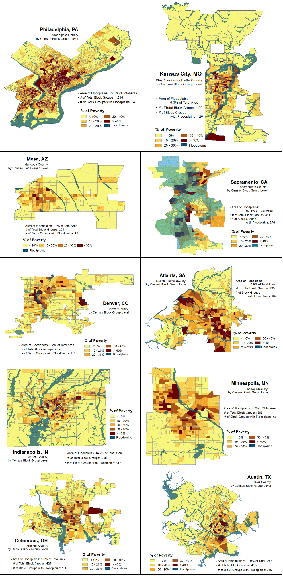
This study uses GIS data and non-GIS data to investigate the relationship between income and flood risks. The floodplain data are originally derived from the Flood Insurance Rate Maps (FIRMs) published by FEMA. This study uses FEMAŌĆÖs 100-year floodplain maps. Data of case areas are collected from a random data sample of the fifty largest cities in the United States in 2010. Ten case cities figure in FEMAŌĆÖs floodplain maps and are not coastal cities to minimize other impacts of flood by seawater. Therefore, this study limits the scope to flooding of rivers. These cities include, Mesa, AZ, Sacramento, CA, Denver, Co, Atlanta, GA, Indianapolis, IN, Minneapolis, MN, Kansas City, MO, Columbus, OH, Philadelphia, PA, and Austin, TX.
GIS, t-test, and Regression analyses are used to investigate the relationship between floodplains and neighborhoodsŌĆÖ income. The unit of analysis, as a proxy of a neighborhood, is the census block group in each city since it is the smallest representative unit of socioeconomic data of census in U. S. Whether many low-income people live in a neighborhood is assessed by using household median income of the neighborhood. For floodplains, the percent of floodplain occupied by a census block group was calculated using GIS analysis. It is based on an assumption that the more floodplains a neighborhood has, the poorer its residents are. Thus, the dependent variables are median household income and the explanatory variable is the percent of floodplain in the neighborhood.
3.2 Overview of Study Areas
Table 1 shows overview of these case cities. The average of median household income and poverty rates is $40,516 and 16.3%, respectively. Of ten case cities, Austin, TX has the greatest median household income ($46,582) and Philadelphia, PA has the lest one ($30,517). Atlanta, GA(24.4%) has the highest poverty rate and Mesa, AZ (8.9%) has the lowest poverty rate among case cities. These case cities include a wide range of floodplains. Sacramento, CA (62.8%) has the largest area of floodplain and Mesa, AZ (2.7%) has the smallest one. About 9.0% of all neighborhoods are covered by floodplains which are over 50% of their areas. Especially, 72.7% of the neighborhoods in Sacramento, CA (226 neighborhoods of total 311 neighborhoods) include more than 50% of floodplains. 154 neighborhoods are located on 100% floodplains. Regarding to neighborhoodsŌĆÖ poverty, 8.0% of all neighborhoods in ten cities have the poverty rate of over 50%. The neighborhoods with more than 50% of poverty rate are 18.2% and 16.3% of neighborhoods in Philadelphia, PA and Atlanta, GA, respectively.
Table┬Ā1
Overview of Ten Case Cities.
Figure 1 represents the location of floodplains of ten case cities. Most neighborhoods in Sacramento, CA are occupied by floodplains. Floodplains in Atlanta, GA, Indianapolis, IN, Columbus, OH, Austin, TX and Kansas City, MO are distributed throughout the cities. The cities which rivers or major creeks run through are Denver, Co, Minneapolis, MN, Columbus, OH, and Austin, TX. Therefore, these citiesŌĆÖ centers are likely to be occupied by floodplains. That means the central areas of the cities are exposed to flood risks.
4. Results
To compare the difference in neighborhoodsŌĆÖ income between inside and outside floodplains, first of all, T-test was conducted (Table 2). For all neighborhoods in ten case cities, mean household income of neighborhoods inside floodplains are higher than those outside floodplains. But when neighborhoods are divided into three according to their income (high- and low-income neighborhoods include neighborhoods with over 120% and less 80% of regionŌĆÖs median household income, respectively), the results are different. In high- and moderate-income neighborhoods, median household income of neighborhoods occupied by floodplains is higher than others. The difference in median household income between inside and outside floodplains is greater in high-income neighborhoods. On the other hand, income of neighborhoods inside floodplains is lower than those outside floodplains in low-income neighborhoods.
Table┬Ā2
Differences in Neighborhoods' Income between Inside and Outside Floodplains (T-test).
| Neighborhoods | Floodplains | Number of Neighborhoods | Mean | Standard Deviation | Difference in Mean |
|---|---|---|---|---|---|
| All | Inside | 1,604 | 43,395 | 25,152 | 8,212* |
| Outside | 4,033 | 35,182 | 18,947 | ||
| High-Income | Inside | 544 | 68,556 | 25,205 | 10,137* |
| Outside | 967 | 58,418 | 21,140 | ||
| Moderate-Income | Inside | 518 | 39,396 | 6,074 | 3,309* |
| Outside | 1,382 | 36,086 | 6,764 | ||
| Low-Income | Inside | 330 | 18,881 | 9,776 | -2,625* |
| Outside | 1,870 | 21,507 | 7,857 |
These results are similar with those of regression analyses for ten case cities (Table 3). Model I shows the relationship between neighborhoodsŌĆÖ income and percent of floodplains in the neighborhoods. The relationship is positive and statistically significant at a 99% confidence level, with a value of 0.047 (P_Foodplains). The result means floodplains location increases neighborhoodsŌĆÖ income by 4.7 percent relative to comparable non-floodplain neighborhoods. That is, residents of neighborhoods with many floodplains, although it means much flood risks, are likely to have higher income.
Table┬Ā3
Relationship between Neighborhoods' Income and Flood Risks for Ten Case Cities.
| Variables | Model I | Model II | Model III | |||
|---|---|---|---|---|---|---|
| B | t | B | t | B | t | |
| (Constant) | .035 | .653 | .265 * | 4.680 | 1.058 * | 25.527 |
| Poverty Rate | -.563 * | -50.269 | -.576 * | -51.483 | -.082 * | -17.377 |
| D_Downtown | .155 * | 13.825 | .020 *** | 2.391 | ||
| D_Downtown_5km | -.371 * | -12.174 | ||||
| D_Downtown_5-10km | -.237 * | -8.469 | ||||
| Low-Income | -1.706 * | -65.872 | ||||
| Moderate-Income | -1.140 * | -57.345 | ||||
| P_Floodplains | .047 ** | 3.164 | .169 * | 4.306 | .079 * | 5.003 |
| P_Flood:Low-Income | -.091 * | -4.981 | ||||
| P_Flood:Moderate-Income | -.070 * | -3.760 | ||||
| P_Flood:D_Downtown_5km | -.134 ** | -3.194 | ||||
| P_Flood:D_Downtown_5-10km | -.149 * | -3.534 | ||||
| Sacramento | -.165 *** | -2.003 | -.069 | -.827 | -0.97 | -1.600 |
| Denver | -.019 | -.307 | .002 | .027 | .014 | .306 |
| Atlanta | -.026 | -.380 | .024 | .352 | .119 *** | 2.369 |
| Indianapolis | -.013 | -.216 | -.049 | -.804 | .000 | -.004 |
| Minneapolis | -.019 | -.298 | .058 | .881 | .018 | .370 |
| Kansas City | -.017 | -.264 | -.053 | -.835 | .111 *** | 2.381 |
| Columbus | -.026 | -.432 | -.037 | -.612 | -.022 | -.489 |
| Philadelphia | .009 | .170 | .000 | -.003 | -.009 | -.231 |
| Austin | -.017 | -.263 | -.001 | -.021 | .043 | .911 |
| R2 | .431 | .427 | .697 | |||
| N | 5,585 | 5,585 | 5,585 | |||
Model II estimates the impact of floodplains on neighborhoodsŌĆÖ income according to distance of neighborhoods to downtown for each case cities. In some case cities, floodplains are concentrated in the central cities. The distance can have an impact of flood risks on neighborhoodsŌĆÖ income. In the model, neighborhoods are divided into three categories (less than 5km (D_Downtown_5km), between 5~10km (D_Downtown_5-10km), and more than 10km from downtown). Of neighborhoods more than 10km away from downtown, neighborhoods inside floodplains have higher income, by 16.9 percent, than those outside floodplains. Two kinds of neighborhoods including less than 5km and between 5~10km away also have higher income in neighborhoods with floodplains (P_Flood:D_Downtown_5km and P_Flood: D_Downtown_5-10km, respectively), although differences in income between inside and outside floodplains are smaller than neighborhoods more than 10km away.
Model III represents the different income between inside and outside floodplains according to neighborhoodŌĆÖs socioeconomic characteristics. Like t-test, the analysis compares difference in income inside floodplains with those outside floodplains according to three income neighborhood groups. According to the results, in high-income neighborhoods, median household income in neighborhoods within floodplains is higher than those in other neighborhoods, by 7.9 percent. moderate-income neighborhoods (P_Flood:Moderate- Income) have a similar tendency with high-income neighborhoods, although difference in income is much smaller (increase of 0.9 percent). On the other hand, low-income neighborhoods have the negative relationship between income (P_Flood: Low-Income) and flood risks, with a decrease of 1.2 percent. That is, relatively higher-income residents live inside floodplains, compared with outside floodplains, in high- and moderate-income neighborhoods and relatively lower-income residents do so in low-income neighborhoods.
5. Conclusions and Policy Implications
This study aimed to understand the relationship between neighborhoodsŌĆÖ income and flood risks. From the post-disaster case studies and a few empirical studies, it tried to verify and generalize a hypothesis or conclusion that low-income people are more likely to be exposed to flood risks, living in floodplains, than others. The result showed that median household income of neighborhoods in floodplains are not likely to be lower than those outside floodplains, even higher. More specifically, high- and moderate-income neighborhoods are more likely to have high income inside floodplains, compared to outside floodplains. In low-income neighborhoods, but neighborhoods inside floodplains have lower income than others.
These results mean that the poorer people live in neighborhoods with floodplains in low-income neighborhoods, although the richer people live in such neighborhoods in high- and moderate-income neighborhoods. These agree with the conclusion of a case study about housing prices in floodplains (Lee 2015). Higher-income in floodplain neighborhoods is related with higher property values in the neighborhoods. U.S. governments encourage property owners in floodplains to purchase flood insurance for preparing flood risks. In general, the insurance value results in higher property values. In many cases, and, floodplains include many amenities of beautiful landscape and leisure activities using water-front. Thus, higher-income population proper to live in neighborhoods with floodplains. On the other hand, residents in low-income neighborhoods do not afford to buy the flood insurance and then experience deterioration of their houses after floods. The value of property in floodplains is lower than others in low-income neighborhoods. As a result, the poorer population live in floodplains, the areas with high flood risks.
To mitigate flood risks, governments have established many policies and plans and tried to implement efficiently them. But there is a limitation that they have not reflected a variety of neighborhoodsŌĆÖ characteristics. This studyŌĆÖs results give a significant implication to complement the existing policies, especially in Korea. According to KoreaŌĆÖs Natural Hazards Management Act, local governments should establish Comprehensive Flood and Storm Management Plans. The plans include structural (dam, building enhancement et al) and non-structural (land use regulation, land acquisition et al) strategies. When establishing and implementing the plans, however, local governments do not consider socioeconomic characteristics of the local areas. Local governments should establish mitigation policies and pre-disaster recovery plan that reflect various needs according to neighborhoodsŌĆÖ socioeocnomics characters. These efforts help to manage consistently, respond immediately and rehabilitate sustainedly various neighborhoods. The local governmentsŌĆÖ these comprehensive efforts through collaboration with other agencies can help minimize the exposure of low-income people to flood risks. The success rate of programs will depend on citizensŌĆÖ consciousness of the threat of floods and the importance of mitigation in the repeatedly flooded areas. It may be necessary for planners to establish education programs to inform citizens of the general threat of floods in the locality and the importance of regulating such areas.
This study has some limitations in explaining the relationship between neighborhoodsŌĆÖ income and flood risks. First, the mismatch between floodplain data and census block groups makes it difficult for planners and policy makers to obtain the real number of low-income people in floodplains and to better understand the relationship between floodplains and low-income people. A parcel-wise analysis method can produce more precise results to confirm these relationships. However, parcel level data including household income or property value is difficult to obtain. Secondly, the presently available data are somewhat outdated. Floodplain data from FEMA are not frequently updated even though floodplains have changed over time. Thus, the results of analyses using these data can be different from the real situation. Nevertheless, this paperŌĆÖs findings clearly show that significant numbers of low-income people are exposed to floods in many cities.


