1. 서 론
최근에는 지구온난화가 지속화되면서 전 세계적으로 높은 기상이변들이 속출하고(Kim et al., 2011) 그로 인한 피해가 급증하였다. 이를 예방하기 위해서 풍수해 피해예측의 필요성이 증가하였고 각기 다른 필요성과 목적에 의하여 다양한 형태로 지도가 작성되고 있다. 풍수해 피해예측을 위하여 작성된 지도는 재해 예방 및 재해경감대책 수립을 위한 기초자료로 활용할 수 있지만 통합된 지도 관리체계가 없어 활용이 어려운 실정이다(Choi, 2011). 국립방재연구원(NDMI, 2015)은 제도 간의 연계와 환류 기능이 미흡하고 제도별로 산재되어 있는 부분이 많아 통합적으로 관리할 수 있는 운영체계가 필요하다고 판단하였다. 따라서 관련 기관과 지자체별로 작성된 지도의 연계⋅활용을 위한 피해예측 시스템 구축 개발 연구가 진행되고 있으며(Sim, 2016), 관리⋅제공을 위한 시스템 구축 개발 연구 또한 활발히 진행되고 있다(Seo et al., 2017).
대한지적공사(Korea Land and GeoSpatial Informatix Corporation, 2010)에서는 지적정보를 타 공간정보와 효율적으로 연계하여 다양한 분야의 수요를 창출할 수 있도록 지적정보 표준 개발을 위한 요구사항 도출과 설계 방향을 정립하여 데이터모델 표준(안)과 메타데이터 표준(안)을 제시하였고, Kang (2012)은 한국형 자연재난 피해 추정이 가능한 시스템의 필요성과 구축 방향을 제시하였다. Yang et al. (2008)은 산사태, 태풍 등의 풍수해 사전 피해예측에 필요한 통합 DB 체계를 구축하고 풍수해의 피해예측 및 대책 수립에 활용할 수 있는 시스템을 시범 구축하였다. Na and Jung (2015)는 공간정보의 융⋅복합을 위해 공간정보 표준 적용 활성화 방안을 제시하였으며 Sim (2016)은 침수지도의 효과적인 통합 운영 및 관리를 위하여 메타데이터의 국제표준 기준인 ISO/TC211 19115에서 필수항목 기준으로 벡터 공간정보 메타데이터를 재구성하여 설계하였다. 또한, Seo et al. (2017)은 ISO/TC211 19115 국제표준 기반으로 핵심 메타데이터 요소를 모두 포함하여 총 9개의 클래스로 구분하여 정의하였으며 하위 개체를 설정하고 개체 항목별 의무/조건 항목을 조정하여 풍수해 피해예측지도 표준 메타데이터를 설계하고 표준메타정보 관리 프로토타입 시스템을 구축하여 메타데이터 및 데이터모델 설계 결과를 검증하였다. 아직 우리나라의 피해예측시스템 개발 단계는 초기 수준에 머물고 있으며 각 기관 또는 지자체별로 일부 지역에 대해 입력 자료를 구축하여 피해예상도를 작성하기 때문에 관련 기관 연구성과의 연계⋅활용을 통한 통합 피해예측 시스템 운영에 어려움을 겪고 있는 실정이다(Jung et al., 2016).
국내 공간정보 표준과 국제 표준 항목을 기반으로 구축한 시스템을 조사, 분석하여 제공 정보와 활용 동향을 살펴보았다. 국내의 경우, 국가수자원관리종합정보시스템(Water Resources Management Information System, WAMIS)은 수자원 관련 수문 정보를 종합적으로 제공하고 있는 대표 사이트로 수문 기상, 유역, 하천, 댐 및 지하수 정보로 구성되어 있다. 또한, 위치기반 정보인 공간정보와 제원, 실시간 측정 자료 등을 축적하고 있어 공간정보 기반의 통계정보, 표준 유역 정보, 유역 단위 정보를 제공하고 있다. 하천관리지리정보시스템(RIMGIS)은 국가하천의 효율적인 관리와 대민서비스의 질 향상, 하천관리업무의 효율성 제고 등을 목표로 하천정보의 표준화 및 전산화를 통한 정보제공 및 하천에 관련한 제반 업무를 지원하기 위해 개발된 시스템이다. 5개 지방국토관리청에서 관리하는 하천대장 및 부도, 구조물도 등 다양한 하천 관련 정보를 바탕으로 인허가 및 하천 기본계획 등의 하천업무를 지원하고, 하천 일반사항, 하천 기본계획 보고서, 홍수위험지도, 국가하천 공간정보 등의 대국민 서비스 제공을 하고 있다. 국내 수자원 관련 표준은 물관리 정보표준에 따르며, 물관리 정보유통시스템(Water Information Network System, WINS)은 관련 기관에서 분산 관리되는 수문 정보를 표준데이터로 통합하여 각 기관에 제공하는 대표적인 유통 사이트로 HTTP/SOAP 방식의 자료교환 프로토콜을 사용하고 있다. 또한, 물관리 정보표준을 업데이트 및 관리하며 물관리 정보표준에 따라 관련 기관 간의 물관리 정보를 공유한다.
국외의 경우, 미국 지질조사국(United States Geo logical Survey, USGS)에서 실시간 물 정보, 재해 관련 정보, 수질 관련 정보 등 다양한 수자원 관련 정보를 GIS 기반으로 제공하고 있으며 국가지도정보시스템(National Atlas)과 연계하여 인구, 지역, 자원 등에 대한 방대한 자료를 웹 GIS 시스템인 Map maker 서비스를 통해 제공하고 있다. 영국 환경청은 홈페이지에서 대기, 토양, 홍수, 수질 등 환경과 관련한 여러 정보를 제공하고 홍수위험 지역을 확인할 수 있는 홍수위험지도가 제공된다. 특히, 실시간으로 홍수 관련 정보가 상세하게 제공되며 다른 정보는 보고서 및 설명 위주로 제공된다.
현재 국내 공간정보 표준과 국제 표준 항목을 기반으로 구축한 시스템들은 각기 다른 표준 정보로 이루어져 있어 통합 관리 및 연계활용이 미흡하며 풍수해 피해예측을 위한 시스템 구축 및 운영이 제한되어 있음을 알 수 있다. 이에 본 연구에서는 풍수해 피해예상도 표준데이터 모델 구축을 위하여 메타데이터 항목을 기술하고 구축된 자료의 검증을 위해 검증기 프로그램인 H-GDM을 개발하여 자료의 정확성을 확보하였다. 또한, 풍수해 피해예상도 표준데이터 모델을 구축하였으며 구축된 표준데이터 모델 운영을 위해 풍수해 피해예상도 공간정보 자료 조회 및 관리 운영 프로그램을 개발하고 적용하였다. 풍수해 피해예상도 표준데이터 모델 운영 프로그램을 통하여 피해지역의 사전 분석에 필요한 지도들의 관련 정보를 체계적으로 연계⋅활용할 수 있고 효율적인 풍수해 예방⋅대응 등에 사용 가능할 것으로 생각한다.
2. 풍수해 피해예상도 표준 데이터모델 구축
2.1 풍수해 피해예상도
2.1.1 호우피해예상도
호우피해예상도는 돌발호우나 태풍으로 인한 홍수 발생 시 인명 및 재산피해를 최소화하기 위해 홍수 지역을 예측할 수 있도록 제작된 지도이다(Kim et al., 2016). 하천법 제 21조, 하천법시행령 제 17조를 근거로 작성되며 지형자료(Digital Elevation Model, DEM), 하천 중심선(Stream Centerline), 하천 횡단면(Cross-Section Line), 제방고(Bank), 수문 기상 자료(Hydrological Data) 등을 사용한다. 호우피해는 하천범람을 원인으로 초래되는 외수 범람과 제내지에서 내수배제 불량 등의 원인으로 발생하는 내수범람으로 구분할 수 있다. 본 연구에서 사용한 호우피해예상도는 홍수 원인에 따라 홍수범람 해석 모형 기반의 정밀 홍수범람예상도와 기본계획 수립하천과 풍수해 저감종합계획 수립지역을 대상으로 한 전국 대상의 지도로 구분하였고, 그 안에서 홍수범람 해석 모형 기반 정밀 홍수범람예상도(a) 및 정밀 내수침수예상도(b)와 기본계획이 수립된 지방하천을 대상으로 작성한 하도 버퍼링 기법 기반 전국 홍수범람예상도(c), 풍수해 저감종합계획 분석 기반 전국 내수침수예상도(d)로 분류하였다(Fig. 1).
2.1.2 바람(강풍) 위험지도
바람(강풍) 위험지도는 균일강풍 지도에 지표 조도, 지형할증을 분석하여 생성한 지도로써 기상관측소에서 측정한 풍속자료를 이용하여 확률적 풍속을 산정한 뒤, 공간적 특성을 고려하여 작성한 지도이다(NEMA, 2009). 바람(강풍)에 대한 위험 분석을 통하여 바람(강풍) 위험지도를 작성할 수 있으며 작성 방법은 극한풍속 산정, 지표 조도산정, 지형할증계수 산정으로 나눌 수 있다. 본 연구에서 사용한 바람(강풍) 위험지도는 극한풍속을 산정할 때 기상관측지점(ASOS, AWS)의 관측 풍속을 극치 이론에 적용하여 재현빈도별 풍속을 산정하였다. 위성영상을 이용하여 토지 피복 분류를 수행하고, 분류된 클래스에 따라 가중치를 두어 8방위 별로 지표 조도를 산정하였으며, 지형할증계수 산정 알고리즘에 공간데이터를 사용하여 산, 언덕, 도심 등 지형에 의한 할증 계수를 산정하였다. Fig. 2는 재현빈도별 산정식에 따라 각 주요인자의 격자연산을 통해 산출된 서울, 경기, 강원의 재현기간 100년에 따른 8방위(북풍, 북동풍, 동풍, 남동풍, 남풍, 남서풍, 서풍, 북서풍)별 바람(강풍) 위험지도이다.
2.1.3 산사태 위험지도
산사태 위험지도는 산지의 산림, 지질, 지형 등 산림환경인자를 조사하고 과거 산사태 발생 이력을 분석하여 위험도를 나타낸 지도이다. 산사태가 발생한 지역의 현지 조사(위성영상, 항공 영상 조사), 위험도 분석, 산사태 위험도 판정알고리즘 작성, GIS를 이용한 위험지 등급화 등의 과정을 거쳐 작성한다. 산사태 발생 가능성이 가장 큰 지역을 1등급으로 총 5등급(1등급(매우 높음), 2등급(높음), 3등급(낮음), 4등급(매우 낮음), 5등급(없음))으로 구분한다. 산사태 정보는 대표적으로 산림청(www.forest.go.kr)의 산사태 정보 시스템에서 제공하고 있으며 산사태 위험지도의 입력 자료는 다양한 산사태 발생 인자 중 영향이 큰 9개 인자(사면 경사, 사면 길이, 사면 곡률, 사면 방위, 지형 습윤 인자(Topographic Wetness Index, TWI), 경급, 모암, 임상, 토심)를 선정하여 제작⋅제공하고 있다.
2.2 풍수해 피해예상도 표준 데이터모델 구축
데이터베이스를 구축할 때 체계화된 구조를 갖추는 것이 필요한데, 이때 데이터베이스 구조를 명시하기 위한 개념들의 집합을 데이터모델(Data Model)이라 한다. 데이터모델은 데이터베이스의 구조뿐만 아니라 이런 구조에서 허용되는 연산 그리고 이런 구조와 연산에 대한 제약 조건을 포함하는 개념이다. 데이터모델로는 계층적 데이터모델, 네트워크형 데이터모델, 관계형 데이터모델, 객체지향형 데이터모델 등이 있다(Kim and Kim, 2013). 기존 관계형 데이터베이스와 데이터모델은 다음 내용과 같은 차이점을 갖고 있다. 관계형 데이터베이스는 기상, 수위, 강수량 등 각각의 항목별로 별도 테이블과 코드성의 공통 테이블로 구성되어 있으며 항목이 추가되면 테이블이 신규로 추가되어야 한다. 하지만, 데이터모델은 메타데이터를 기반으로 데이터 항목을 한 테이블로 관리하기 때문에 항목이 추가되어도 별도의 테이블을 추가할 필요가 없는 장점이 있다.
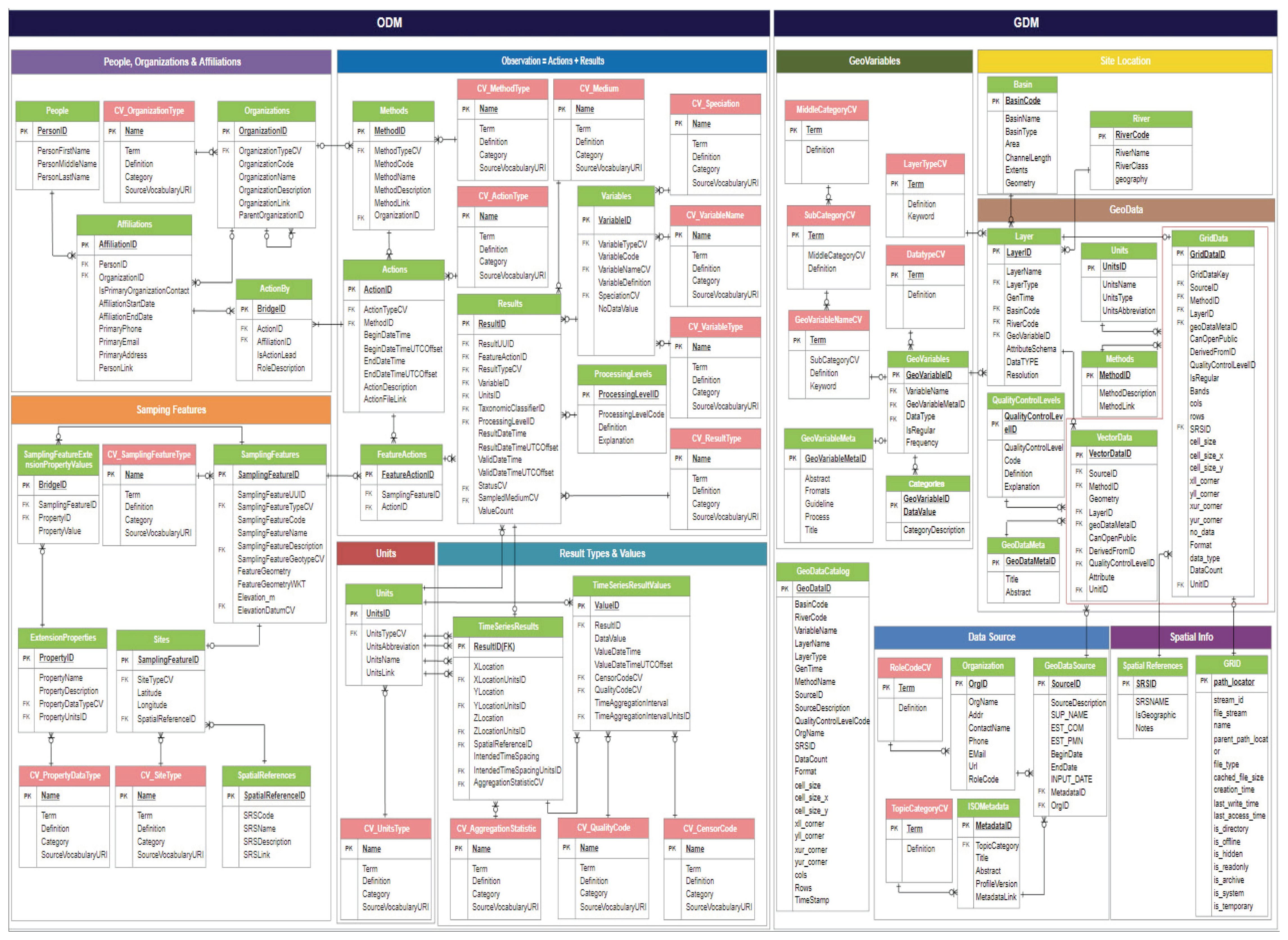
객체지향형 모델인 Observation Data Model (ODM)은 기존 ODM (Horsburgh et al., 2008)의 개념과 기타 지구과학 사이버 기반시설을 통합하여 개발된 모델로 인터넷을 통해 데이터를 보관⋅전송하기 위한 관측 데이터를 일관되게 설명, 저장 및 관리할 수 있는 능력을 확장한 모델이다. 핵심 스키마와 여러 확장 스키마로 구성되어 있으며 핵심 스키마는 Open Geospa tial Consortium (OGC)의 Observation & Measurements (O&M) 표준의 관측 개념을 기반으로 개발하였으며, 유형과 관계없이 모든 관측에 공통적인 개체, 속성 및 관계가 포함된다. 또한, 확장 스키마는 특정 데이터 유형에 필요한 개체, 속성 및 관계가 포함되며 이를 ODM 2.0에 새로운 기능으로 추가할 수 있다. 따라서, 완전한 ODM 2.0을 사용하거나 핵심 및 필요한 확장 스키마를 선택적으로 사용 가능하므로 모델 구현의 복잡성을 제어할 수 있으며, 확장을 통해 새로운 기능을 쉽게 추가할 수 있다.
풍수해 피해예상도 표준데이터 모델 메타데이터는 ODM과 Hydro Geospatial Data Model (H-GDM)로 구성되어 있다. ODM은 수문 관측자료로 구성되며, H-GDM은 공간정보로 구성되어 있다. H-GDM은 Vector, Raster의 통합 모델로 Vector 정보와 Raster 정보가 GDM 단일 데이터모델 안에서 통합 관리되며, GeoVariavles Table에 공통으로 연계되는데 공간정보 특성상 그사이에 Layer 정보를 경유한다. Document Store 방식의 NoSQL DBMS 기술을 도입하여 공간정보의 속성필드 명칭, 개수에 제약 없이 동반 속성정보를 모두 저장, 관리한다.
풍수해 피해예상도 표준데이터 모델을 구축하기 위해서 사용되는 데이터 항목을 분석하여 구축 대상 데이터 항목을 선정하였다. 피해예상도 작성을 위한 기초자료, 중간산출물, 최종산출물로 구분되며, 시공간적으로는 공간자료, 시계열 자료(수문 자료)로 구분된다. 자료 타입은 공간자료는 shp, dwg, asc, img 등이 있으며, 시계열 자료는 csx, TIN, JSON 형태가 존재한다. 기초자료의 포함 항목은 대표적으로 공간자료에는 지형 DEM이 있으며 수문 자료는 WAMIS Open API와 연계된 강수량, 수위, 유량 관측소의 자료이다. 중간산출물로는 측선별 홍수위와 빈도별 홍수위 DEM 등이 생성되며 최종산출물로는 빈도별 침수심에 대한 자료이다(Table 1). 데이터 항목을 선정한 후, 시계열 데이터와 공간정보를 연계한 확장형 국제 표준데이터 모델 설계에 반영하였으며 시계열 데이터는 2016년에 개정된 CUAHSI ODM 2.0을 도입하고 공간정보는 H-GDM을 설계하였으며 데이터모델 관계도(Entity-Relationship Diagram, ERD)를 표시하였다(Fig. 3).
2.3 표준데이터 모델 메타데이터 항목 구축
풍수해 피해예측지도 표준데이터 모델 구축을 위하여 설계한 ODM과 H-GDM의 설계 및 관리를 위해서 체계적인 메타데이터 설계와 구축이 필요하므로 공간데이터 표준 메타데이터 테이블을 구성하여 구축하였다. ODM 관측자료 구축은 강수량, 수위, 기상, 유량 등 수문관측소의 제원과 관측값을 기반으로 타 기관 자료를 연계하여 표준데이터 모델에 적합하게 구축된다. ODM 관측자료 구축 목록은 관측 통계, 관측결과, 관측소 제원 등으로 구성된다(Table 2).
ODM 2.0의 메타데이터 구성은 담당 기관, 관측방법, 관측종류, 단위 등을 포함하고 있다(Table 3).
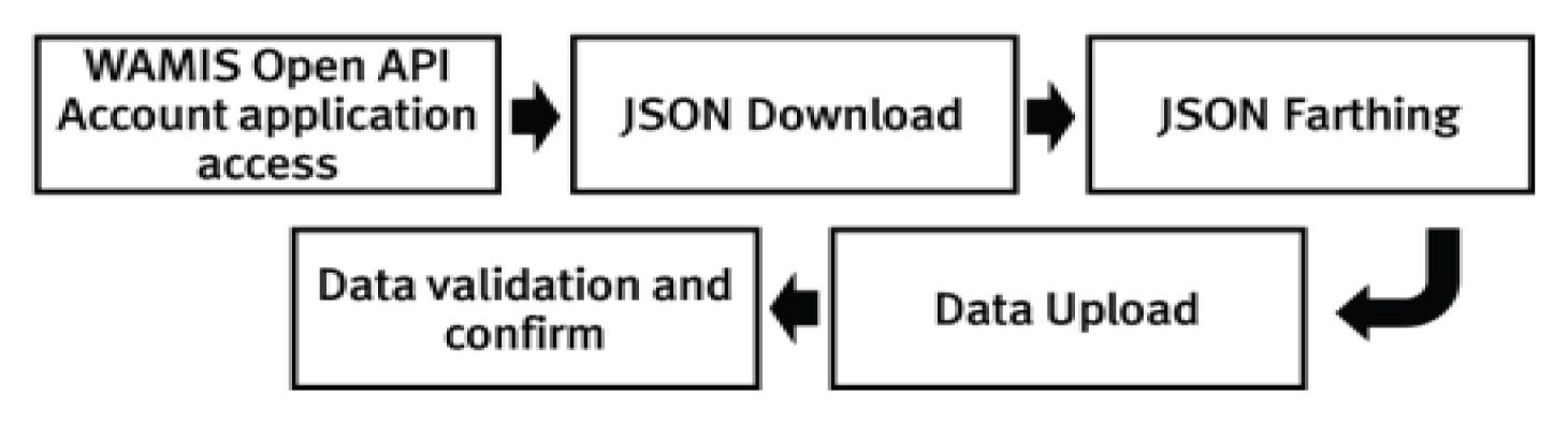
구축하는 데이터는 기상청, 환경부 Open API를 통해서 연계⋅구축하였다. 예를 들면 Open API에서 수위 자료를 구축하면 관측소 검색, 관측소 제원, 시 자료, 일 자료를 사용할 수 있다. 관측자료의 자료변환을 위해서 Fig. 4와 같이 WAMIS Open API를 접속하여 JSON을 다운로드하여 파싱 후 데이터를 업로드하면 자료를 검수하고 확인할 수 있도록 절차를 정립하였다.
또한, ODM 2.0을 구축하기 위하여 Fig. 5와 같은 절차를 정립하였다. 시계열 정보 자료변환은 세부적으로 관측소 제원 정보와 실시간 자료로 구분하였다. Open API 사용 시 제원 정보는 관측소 종류와 권역을 검색조건으로 사용한다. 다운로드 받은 자료는 ODM의 Samplingfeatures 등 5개의 테이블에 저장되며 실시간 자료는 관측소 종류, 권역, 자료 종류(일 자료, 시 자료), 검색조건으로 사용하여 ODM의 Results, Timeseriesresults 테이블에 저장된다.
수위관측소에서 관측 타입(Observation, Analysys, Estimation), 관측방법, 관측개시일, 종료일 등 관측을 위한 행위에 관련된 자료들은 Actions, Methods와 같은 테이블에 구축할 수 있고 관측결과는 Results 테이블에 구축한다. 담당 기관과 같은 자료들은 Organizations와 같은 관측소의 소속을 나타낼 수 있는 People, Organizations & Affiliations 영역에 구축할 수 있다. 관측소 정보들은 SamplingFeature영역으로 구축할 수 있고 SamplingFetures, Site 테이블에 담을 수 없는 자료들은 SamplingFeature ExtensionPropertyValues 테이블에 구축한다. 일 자료와 시 자료들은 TimeSeriesResults, TimeSeriesResult Values 테이블에 구축한다. 일 자료와 시 자료를 구분하는 단위와 관측값들의 단위 등을 Units 테이블을 통해 구축한다.
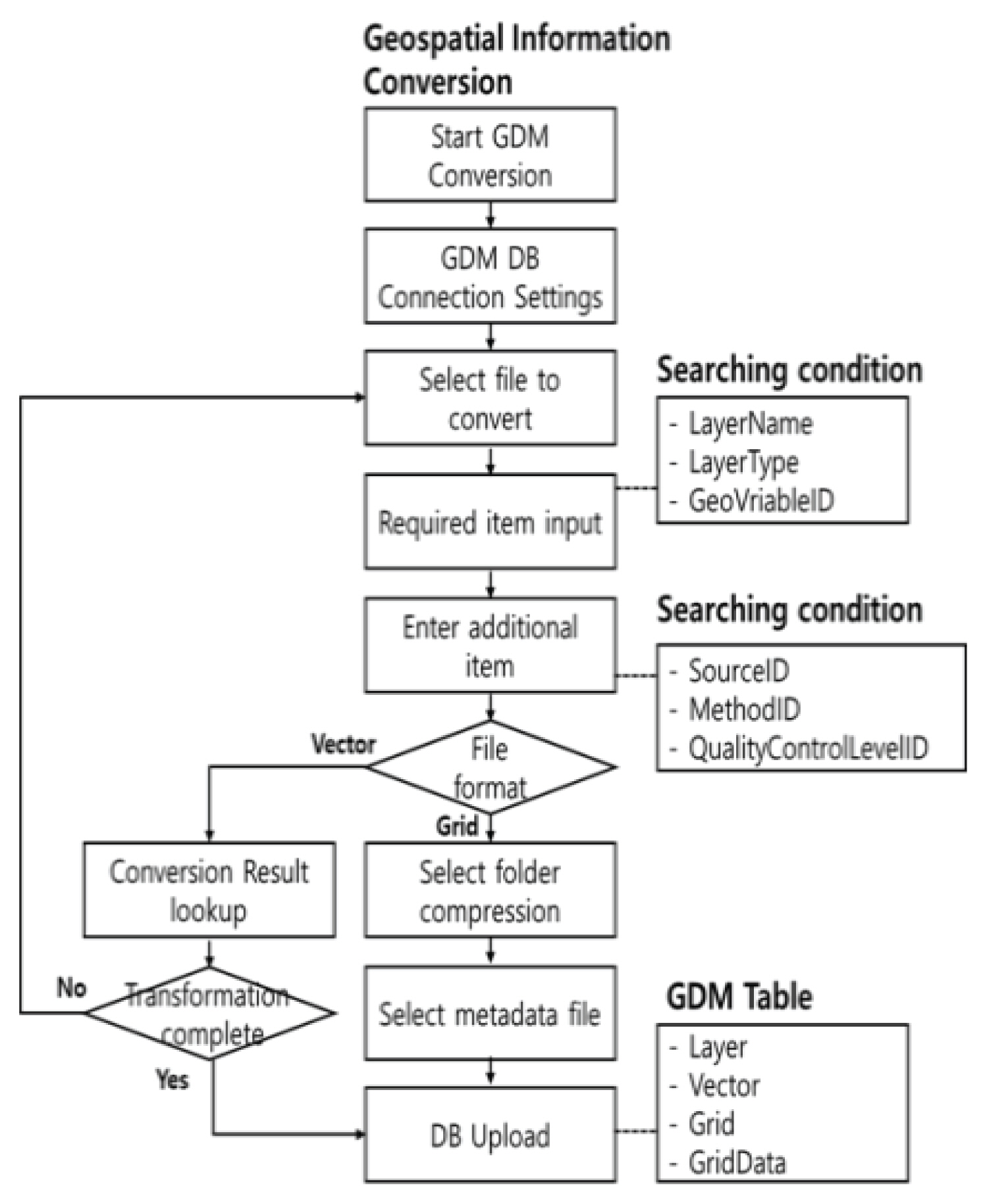
H-GDM 자료 구축은 메타데이터 테이블과 실제 데이터가 저장되는 테이블로 구분되는데 먼저 메타데이터는 GeovariablenameCV (공간정보 변수명), Geovariablename (공간정보 변수), LayertapeCV (레이어 형식), Quality controllevels (품질) 등이 있다. 표준 메타데이터 테이블을 설계(Table 4)하였고 각 테이블은 영문명과 한글명, 타입, 길이, NULL 등을 포함한다. H-GDM 구축 절차는 Fig. 6과 같다.
H-GDM 공간자료는 벡터 자료(Shape)와 그리드(Grid) 자료(Tiff, IMG, Ovr 등)로 구분되며 자료에 대한 자료명, 벡터 및 그리드 자료 유형, 하천 코드, 행정 코드 등 기본 정보는 Layer 테이블에 저장되고, 실제 자료는 Vectordata와 Grid 테이블에 구축된다(Table 5).
3. 풍수해 피해예상도 표준 데이터모델 운영 프로그램 적용
3.1 표준데이터 모델 운영 프로그램 적용 방법
운영 프로그램은 표준데이터 모델에 자료를 구축하기 위한 프로그램으로 지속적인 품질관리를 통해 표준데이터 모델이 갱신되는 체계로 구성되어 있다. 표준데이터의 품질관리를 위해 H-GDM 검증기를 개발하여 풍수해 피해예상도 표준데이터 모델의 구축된 지도 데이터들을 검증하였다. H-GDM 검증은 공간객체의 일관성, 연결성, 무결성 등을 검증하게 된다. 표준데이터 모델에 구축된 공간정보의 정합성을 확보하기 위하여 벡터 자료에 대한 폐합 여부(Closed), 면, 선의 끊김 여부(Empty 여부), 교차 여부(Closed)를 검사한다(Fig. 7). 공간정보의 객체정보를 폐합 여부, 자체교차 여부 등 지오메트리 정보를 검증하고 객체별로 검증된 공간정보 명세를 식별 가능한 정보와 함께 구축된 자료에 대한 검사결과를 리스트를 제공하여 확인할 수 있도록 표출한다(Fig. 8).
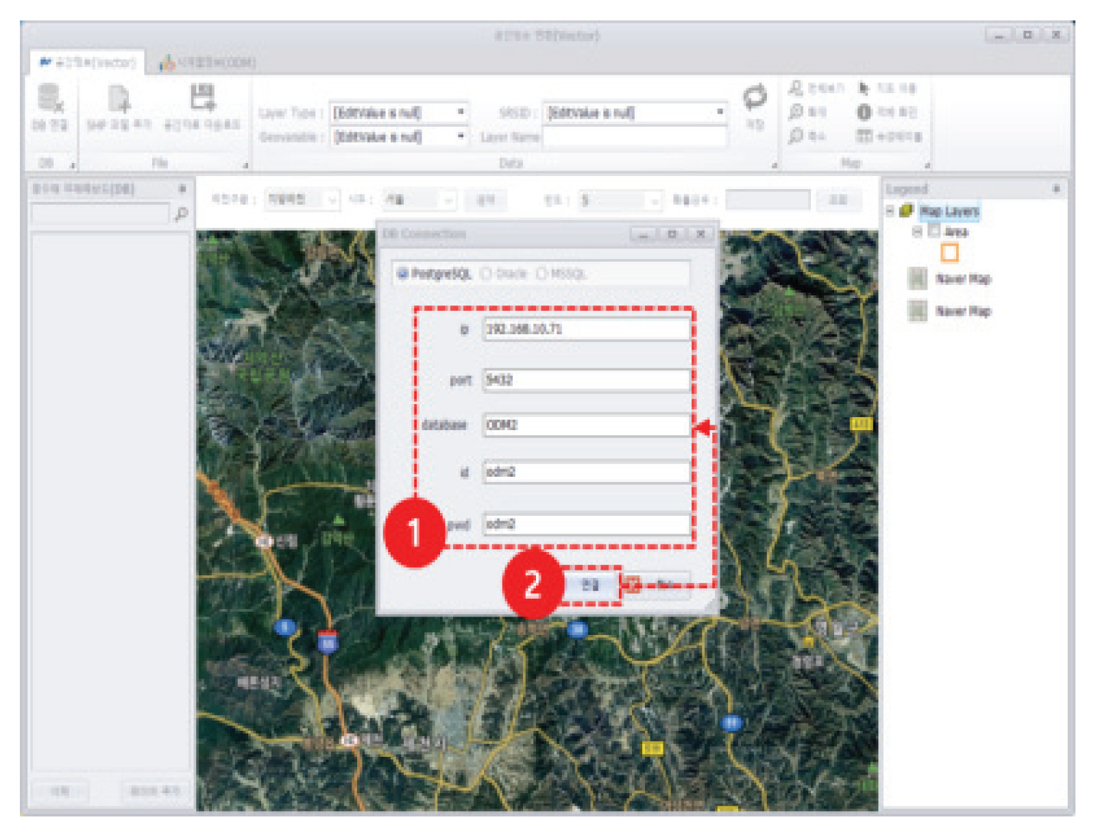
풍수해 피해예상도 표준데이터 모델에서 사용하는 PostgreSQL, PostGIS를 설치하여 표준데이터 모델 구성을 위해 사용자, 데이터베이스, 서버 생성 세 단계를 진행한다. 사용자 생성은 권한의 주체를 지정하기 위해 진행되며 데이터베이스 생성은 Owner 사용자의 설정 및 언어 타입 설정을 통해 진행된다. 생성한 사용자와 데이터베이스에 접속할 서버를 생성하여 서버 이름과 접속할 서버 그룹을 설정하였다. 표준데이터 모델의 처음 구성을 위해 PostgreSQL, PostGIS 설치부터 사용자, 데이터베이스, 서버 생성까지 진행하면 서버에 접속하여 초기 구성 단계를 확인할 수 있다(Fig. 9).
4. 결 론
기후변화로 인한 풍수해 피해를 예방하기 위해서 풍수해 피해예측의 필요성이 증가하였고 형태가 다양한 지도들을 연계활용 하기 위하여 풍수해 피해예상도 표준데이터 모델을 구축하였다. 풍수해 피해예상도 데이터 항목을 분석하여 구축 대상 항목을 선정하였고 선정한 데이터 항목을 분류하여 시계열 데이터와 공간정보를 연계한 확장형 국제 표준데이터 모델 설계에 반영하였다. 시계열 데이터는 ODM 2.0을 도입하고 공간정보는 H-GDM을 설계하였다. 표준데이터 모델의 품질관리를 위해 H-GDM 검증기를 개발하여 표준데이터 모델이 갱신될 때 지속적인 품질관리가 가능하고 자료의 정합성을 확보하도록 하였다. 구축된 데이터 모델을 운영 프로그램에 적용하여 레이어 항목을 지역별, 하천별로 검색 및 조회가 가능하며 편의를 위해 하천의 공간정보를 파일 형식으로 저장할 수 있다.
본 연구에서는 풍수해 피해예상도 표준데이터 모델을 설계하고 피해예상도 자료를 구축하여 운영 프로그램에 적용하였으며 풍수해 피해예상도 표준데이터 모델 운영 프로그램의 사용을 위하여 테크니컬 매뉴얼을 작성하여 추후 활용에 용이할 것으로 판단된다. 작성된 피해예상도를 대상으로 표준데이터 모델에 변환하여 적용하였기 때문에 다양한 지도가 구축되지 않아 표준데이터 모델의 한계성이 있었다. 추후의 다양한 종류의 재해지도를 표준데이터 모델에 구축하여 검증된 후 풍수해 피해를 예방하기 위한 관련 정보들을 체계적으로 연계⋅활용하고 효율적인 풍수해 예방⋅대응 등에 사용 가능할 것으로 판단된다.